Home » World Maps » Europe » Iceland
Iceland Map and Satellite Image

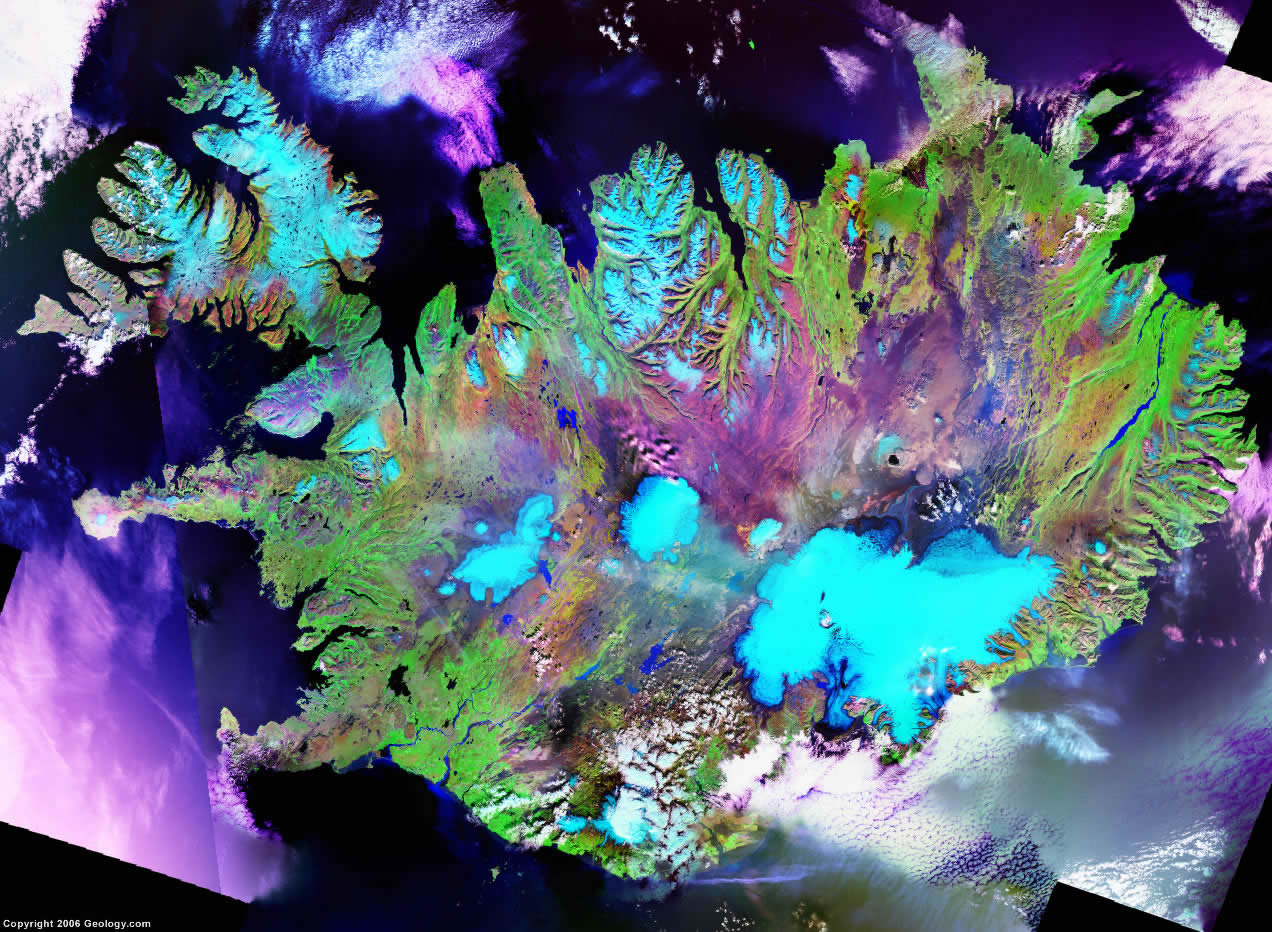
| Iceland is an island northwest of The United Kingdom and Norway. Iceland is bordered by the Greenland Sea and the Atlantic Ocean. |
ADVERTISEMENT
Iceland Bordering Countries:
NoneRegional Maps:
Map of Greenland, Map of the Arctic Ocean, Map of Arctic Ocean Seafloor Features, Map of Europe, World MapWhere is Iceland?

Iceland Satellite Image
ADVERTISEMENT

Explore Iceland Using Google Earth:
Google Earth is a free program from Google that allows you to explore satellite images showing the cities and landscapes of Iceland and all of Europe in fantastic detail. It works on your desktop computer, tablet, or mobile phone. The images in many areas are detailed enough that you can see houses, vehicles and even people on a city street. Google Earth is free and easy-to-use.
Iceland on a World Wall Map:
Iceland is one of nearly 200 countries illustrated on our Blue Ocean Laminated Map of the World. This map shows a combination of political and physical features. It includes country boundaries, major cities, major mountains in shaded relief, ocean depth in blue color gradient, along with many other features. This is a great map for students, schools, offices and anywhere that a nice map of the world is needed for education, display or decor.
Iceland On a Large Wall Map of Europe:
If you are interested in Iceland and the geography of Europe our large laminated map of Europe might be just what you need. It is a large political map of Europe that also shows many of the continent's physical features in color or shaded relief. Major lakes, rivers,cities, roads, country boundaries, coastlines and surrounding islands are all shown on the map.Iceland Cities and Towns:
Akranes, Akureyri, Arnarstapi, Blonduos, Bolungavik, Bordeyri, Borgarnes, Budardalur, Budir, Dalvik, Djupivogur, Egilsstadhir, Eskifjordhur, Flateyri, Grindavik, Grundarfjordur, Hafnarfjordhur, Hella, Hellissandur, Hnifsdalur, Hofdhakaupstadhur, Hofn, Holmavik, Husavik, Hvammstangi, Isafjordhur, Keflavik, Kopavogur, Neskaupstadhur, Olafsfjordhur, Olafsvik, Raufarhofn, Reykjavik, Sandgerdhi, Saudharkrokur, Selfoss, Seydhisfjordhur, Siglufjordhur, Stokkseyri, Stykkisholmur, Sudhavik, Sudhureyri, Thingeyri, Vatneyri, Vestmannaeyjar, Vik, and Vopnafjordhur.Iceland Regions:
Capital Region (Hofudhborgarsvaedhi), Eastern Region (Austurland), Northeastern Region (Nordhurland eystra), Northwestern Region (Nordhurland vestra), Southern Peninsula (Sudhurnes), Southern Region (Sudhurland), Western Region (Vesturland), and Westfjords (Vestfirdhir).Iceland Glaciers:
Drangajokull, Eiriksjokull, Eyjafjallajokull, Hofsjokull, Langjokull, Myrdalsjokull, Thorisjokull, Tungnafellsjokull, and Vatnajokull.Iceland Locations:
Arnarvatn, Atlantic Ocean, Blanda River, Breidhafjordhur, Denmark Strait, Faxafloi, Greenland Sea, Grimsey Island, Heimaey Island, Heradsvotn River, Hofsa River, Hunafloi, Hvita River, Jokulsa a Bru River, Jokulsa a Fjollum River, Kaldakvisl River, Lagarfljot River, Logurinn, Myvatn, Odadahraun (Lava Fields), Oskjuvatn, Skafta River, Skjalfandafljot River, Surtsey Island, Thingyallavatn, Thjorsa River, Thorisvatn, and Thvera River.Iceland Natural Resources:
Iceland's natural resources include fish and diatomite. The country has fuel resources which include the capability for geothermal power and hydropower.Iceland Natural Hazards:
Some of the natural hazards for Iceland are its volcanic activity and earthquakes.Iceland Environmental Issues:
Some of the environmental issues for Iceland are water-related, such as pollution from fertilizer runoff.
ADVERTISEMENT