Home » Articles » Oil & Gas » Arctic Ocean Seafloor Features Map
Arctic Ocean Seafloor Features Map
Major Basins, Ridges, Shelves and Bathymetry
Article by: Hobart M. King, PhD

Arctic Ocean Seafloor Features Map: International Bathymetric Chart of the Arctic Ocean annotated with the names of seafloor features.
Northwest Passage - Northern Sea Route: Map showing the geographic extent of the Arctic Ocean (as a darker blue tint). The Northwest Passage and Northern Sea Route are two important seasonal waterways that connect the Atlantic and Pacific Oceans. In recent years the polar ice pack has thinned, allowing for increased navigation through these routes and raising the possibility of future sovereignty and shipping disputes among countries bordering the Arctic Ocean. Image by the Central Intelligence Agency.
Arctic Ocean: History and Now
The Arctic Ocean has played a minor role in world history. Ice cover severely hinders navigation; the area is remote; there is almost no infrastructure; winters are dark and very cold; summer days are short and foggy. These challenges make the Arctic Ocean a hostile and difficult area.
Today, we are at a time when interest in the Arctic Ocean is growing steadily. A warming climate is thinning and shrinking the polar ice pack to allow increased navigation. New oil and gas assessments have revealed an enormous energy resource. And, the Law of the Sea Treaty has motivated nations to clearly define their exclusive economic zone in the Arctic Ocean.
The new interest in the Arctic Ocean is not confined to its surface; it extends to the bottom where information about its structure is needed by geologists, oceanographers, biologists and other people who work there. The primary physical features of the Arctic Ocean seafloor are labeled on the bathymetry map above and described in the paragraphs below. We also have a much larger version of the Arctic Ocean Bathymetry Map shown above. Other maps on this page illustrate navigational, physical, and mineral resource features.
Arctic Ocean Geography
The Arctic Ocean has a surface area of about 14.056 million square kilometers (5.427 million square miles), making it the smallest of Earth's five oceans. Baffin Bay, Barents Sea, Beaufort Sea, Chukchi Sea, East Siberian Sea, Greenland Sea, Hudson Bay, Hudson Straight, Kara Sea, and Laptev Sea are generally considered to be part of the Arctic Ocean. It is connected to the Pacific Ocean through the Bering Strait and connected to the Atlantic Ocean through the Labrador Sea and the Greenland Sea.
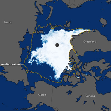
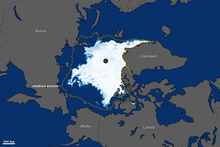
Arctic Ocean sea ice: In September 2011, sea ice covering the Arctic Ocean declined to the second-lowest extent on record. In this image, ice-covered areas range in color from white (highest concentration) to light blue (lowest concentration). Open water is dark blue, and land masses are gray. The yellow outline shows the median minimum ice extent for 1979-2000 (areas that were at least 15 percent ice-covered in at least half the years between 1979 and 2000). Enlarge image. Image and caption information by NASA's Earth Observatory [3].
Lomonosov Ridge
The dominant topographic feature of the Arctic Ocean seafloor is the Lomonosov Ridge. This feature is thought to be part of the Eurasian continental crust that rifted from the Barents-Kara Sea margin and subsided in early Tertiary time (about 64 to 56 million years ago). The side of the Ridge facing Eurasia is bounded by half-graben faults, and the side facing North America is gently sloping.
The Lomonosov Ridge traverses the Arctic Ocean from the Lincoln Shelf (off Ellesmere Island and Greenland) to the New Siberian Islands off the coast of northern Russia. It divides the Arctic Ocean into two major basins: the Eurasian Basin on the Eurasian side of the ridge and the Amerasian Basin on the North American side. It rises over 3000 meters above the floors of these basins and at its highest point is about 954 meters below sea level. It was discovered by Russian scientists in 1948.
In 1982 a United Nations treaty known as the "Law of the Sea" was presented. It addressed navigational rights, territorial waters limits, exclusive economic zones, fishing, pollution, drilling, mining, conservation, and many other aspects of maritime activity. It was the first attempt by the international community to establish a formal agreement on a logical allocation of ocean resources. Under the Law of the Sea, each country receives exclusive economic rights to any natural resource that is present on or beneath the sea floor out to a distance of 200 nautical miles beyond their natural shorelines. In addition to the 200 nautical mile economic zone, each country can extend its claim up to 350 nautical miles for those areas that can be proven to be an extension of that country's continental shelf.
Nations could use the "Law of the Sea" treaty to determine who owns the Arctic Ocean seafloor. Russia has presented a claim to the United Nations that the Lomonosov Ridge is an extension of Eurasia and that entitles Russia to an extended exclusive economic zone. Canada and Denmark make similar claims to extend their control from the opposite side of the Arctic Ocean.
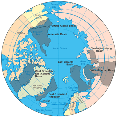
Arctic Oil and Natural Gas Provinces Map: Over 87% of the Arctic's oil and natural gas resource (about 360 billion barrels oil equivalent) is located in seven Arctic basin provinces: Amerasian Basin, Arctic Alaska Basin, East Barents Basin, East Greenland Rift Basin, West Greenland-East Canada Basin, West Siberian Basin, and the Yenisey-Khatanga Basin. Map by Geology.com and MapResources.
Amerasian and Eurasian Basins
The Lomonosov Ridge divides the floor of the Arctic Ocean into two major basins. The Eurasian Basin is on the Eurasian side of the Lomonosov Ridge, and the Amerasian Basin is on the North American side of the Lomonosov Ridge.
The Amerasian and Eurasian Basins have been subdivided by ridges. The Gakkel Ridge, a spreading center responsible for the rifting of the Lomonosov block from the Eurasian continent, divides the Eurasian Basin into the Fram Basin on the Lomonosov side of the ridge and the Nansen Basin on the Eurasian continent side. The Alpha Ridge divides the Amerasian Basin into the Canada Basin on the North American side of the ridge and the Makarov Basin on the Lomonosov side of the ridge.
Continental Shelves
The Amerasian Basin and the Eurasian Basin are surrounded by extensive continental shelves. These include the Chukchi Shelf and the Beaufort Shelf along North America; the Lincoln Shelf along northern Greenland; the Barents Shelf, Kara Shelf, Laptev Shelf, and East Siberian Shelf along Eurasia.
Enormous amounts of natural gas are believed to be beneath the Barents Shelf and the Kara Shelf as parts of the East Barents Petroleum Province and the West Siberian Petroleum Province. Oil and natural gas are believed to be beneath significant parts of the Chukchi Shelf, Beaufort Shelf, and Canada Basin as part of the Arctic Alaska Petroleum Province and the Amerasia Petroleum Province (see map).
Rift Basins
Greenland is flanked by two rift basins: the East Greenland Rift Basin and the West Greenland Rift Basin. These basins connect the Arctic Ocean with the Atlantic Ocean. Each of these basins is thought to be underlain by a significant oil and natural gas resource.
| Arctic Ocean References |
|
[1] Oil and Natural Gas Resources of the Arctic: Geology.com, website article, 2011.
[2] Who Owns the Arctic Ocean? Geology.com, website article, 2008. [3] Arctic Ocean Sea Ice Minimum 2011: NASA Earth Observatory, website article, September 2011. [4] Arctic Ocean: Map from the CIA World Factbook website, Central Intelligence Agency. Now hosted on the Internet Archive. [5] International Bathymetric Chart of the Arctic Ocean: Produced by investigators representing the Intergovernmental Oceanographic Commission (IOC), the International Arctic Science Committee (IASC), the International Hydrographic Organization (IHO), the US Office of Naval Research (ONR), and the US National Geophysical Data Center (NGDC). Map accessed April 2012. [6] The United Nations Convention on the Law of the Sea: United Nations Division for Ocean Affairs and the Law of the Sea. December 1982. [7] Maritime Jurisdiction and Boundaries in the Arctic Region: International Boundaries Research Unit, map and notes published by Durham University, December 2011. |
Navigation Through the Arctic Ocean
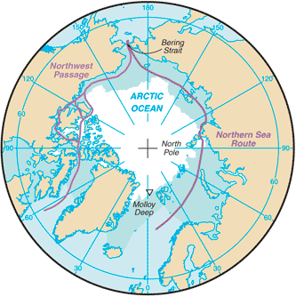
Two potentially important navigation channels pass through the Arctic Ocean (see map). The Northwest Passage is a sea route that connects the Pacific Ocean to the Atlantic Ocean across the northern coast of North America and through the Canadian Arctic Archipelago. The Northern Sea Route is a similar route that connects the Atlantic Ocean to the Pacific Ocean across the northern coast of the Eurasian Continent.
Both of these routes have been virtually impassable in the past because they are covered by thick, year-round sea ice. However, they have been relatively ice-free for a few weeks in recent years (see map) and have attracted a small amount of commercial shipping. Each of these routes cuts thousands of miles off of a trip from the Atlantic to the Pacific. Both routes face jurisdictional problems and questions over who has a right to use them and under what conditions.
| More Oil |
 |
The Doorway to Hell |
 |
Oil Sands |
 |
Shale Gas Resources |
 |
Gifts That Rock |
 |
Horizontal Drilling |
 |
Oil and Gas Rights |
 |
Natural Gas Prices |
 |
Oil Shale |

Find Other Topics on Geology.com:

|

| ||

|

| ||

|

| ||

|

|