Home » World Maps » Africa » Malawi
Malawi Map and Satellite Image
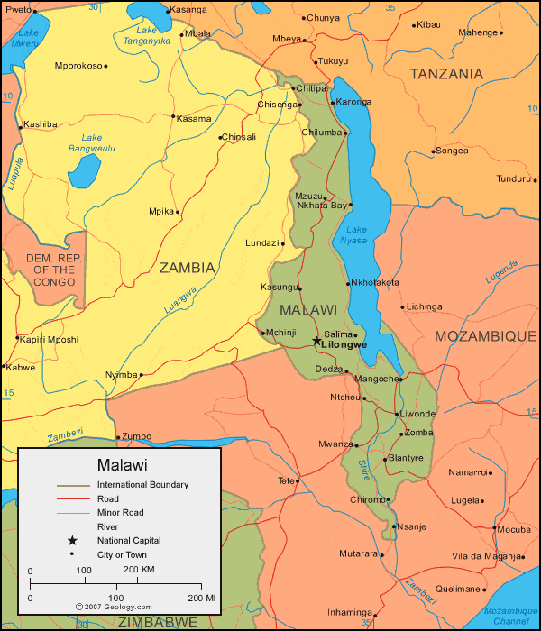
| Malawi is located in southern Africa. Malawi is bordered by Tanzania to the north, Zambia to the west, and Mozambique to the west, south, and east. |
ADVERTISEMENT
Malawi Bordering Countries:
Mozambique, Tanzania, ZambiaRegional Maps:
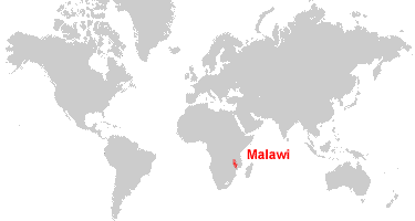
Map of Africa, World MapWhere is Malawi?
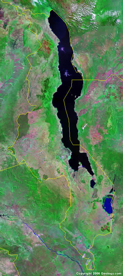
Malawi Satellite Image
ADVERTISEMENT

Explore Malawi Using Google Earth:
Google Earth is a free program from Google that allows you to explore satellite images showing the cities and landscapes of Malawi and all of Africa in fantastic detail. It works on your desktop computer, tablet, or mobile phone. The images in many areas are detailed enough that you can see houses, vehicles and even people on a city street. Google Earth is free and easy-to-use.
Malawi on a World Wall Map:
Malawi is one of nearly 200 countries illustrated on our Blue Ocean Laminated Map of the World. This map shows a combination of political and physical features. It includes country boundaries, major cities, major mountains in shaded relief, ocean depth in blue color gradient, along with many other features. This is a great map for students, schools, offices and anywhere that a nice map of the world is needed for education, display or decor.
Malawi On a Large Wall Map of Africa:
If you are interested in Malawi and the geography of Africa our large laminated map of Africa might be just what you need. It is a large political map of Africa that also shows many of the continent's physical features in color or shaded relief. Major lakes, rivers, cities, roads, country boundaries, coastlines and surrounding islands are all shown on the map.Malawi Cities:
Balaka, Blantyre, Chilumba, Chiradzulu, Chiromo, Chisenga, Chitipa, Dedza, Karonga, Kasungu, Kasupe, Lilongwe, Limbe, Liwonde, Mangoche, Matope, Mchinji, Monkey Bay, Mulange, Mwanza, Mzimba, Mzuzu, Ncheu, Neno, Nkhata Bay, Nkhotakota, Nsanje, Ntcheu, Salima and Zomba.Malawi Locations:
Lake Chilwa, Lake Malawi (Nyasa), Lake Malombe and Shire River.Malawi Natural Resources:
The country of Malawi has unexploited deposits of uranium, coal, and bauxite. Other natural resources include limestone, arable land and hydropower.Malawi Natural Hazards:
Natural hazards in Malawi include droughts and flooding. Earthquakes are also a hazard.Malawi Environmental Issues:
Malawi, in southern Africa, has water pollution from agricultural runoff, sewage and industrial wastes. The country's fish populations are endangered due to the siltation of their spawning grounds. The environmental issues for the land include degradation and deforestation.
ADVERTISEMENT