Home » World Maps » Europe » Norway
Norway Map and Satellite Image

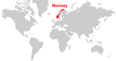
| Norway is located in northern Europe. Norway is bordered by the North Sea and the Norwegian Sea, and Sweden to the east. |
ADVERTISEMENT
Norway Bordering Countries:
Finland, Sweden, RussiaRegional Maps:
Svalbard, Europe, World Map
Where is Norway?

Explore Norway Using Google Earth:
Google Earth is a free program from Google that allows you to explore satellite images showing the cities and landscapes of Norway and all of Europe in fantastic detail. It works on your desktop computer, tablet, or mobile phone. The images in many areas are detailed enough that you can see houses, vehicles and even people on a city street. Google Earth is free and easy-to-use.
Norway on a World Wall Map:
Norway is one of nearly 200 countries illustrated on our Blue Ocean Laminated Map of the World. This map shows a combination of political and physical features. It includes country boundaries, major cities, major mountains in shaded relief, ocean depth in blue color gradient, along with many other features. This is a great map for students, schools, offices and anywhere that a nice map of the world is needed for education, display or decor.
Norway On a Large Wall Map of Europe:
If you are interested in Norway and the geography of Europe our large laminated map of Europe might be just what you need. It is a large political map of Europe that also shows many of the continent's physical features in color or shaded relief. Major lakes, rivers,cities, roads, country boundaries, coastlines and surrounding islands are all shown on the map.ADVERTISEMENT
Norway Cities:
Alesund, Batsfjord, Bergen, Berlevag, Bodo, Drammen, Floro, Fredrikstad, Gulgofjord, Hammerfest, Harstad, Kongsfjord, Kristiansand, Kvaenangsbotn, Lakselv, Leirpollen, Makkaur, Mo i Rana, Molvik, Namsos, Narvik, Oslo, Skien, Stavanger, Syltefjord, Tromso, Trondheim and Vardo.Norway Locations:
Baltic Sea, Barents Sea, Folda, Frohavet, Gulf of Bothnia, Hortafjorden, Jiesjavre, Langvatnet, Lopphavet, Moldefjorden, North Sea, Norwegian Sea, Ofotfjorden, Oslofjorden, Porsangen, Sandoyfjorden, Skagerrak, Sognefjorden, Trondheimsfjorden, Tyrifjorden, Varagnerfjorden and Vestfjorden. Dependent areas of Norway include Svalbard, Jan Mayen, and Bouvet Island.Norway Natural Resources:
The country of Norway has numerous metallic resources which include iron ore, copper, lead, zinc, titanium, pyrites and nickel. Some of the fuel resources include petroleum, natural gas and hydropower. Other resources include fish and timber.Norway Natural Hazards:
Natural hazards for the country of Norway include avalanches and rockslides.Norway Environmental Issues:
The country of Norway has several environmental issues. These include water pollution, and air pollution from vehicle emissions. There is acid rain, which is damaging the forests and adversely affecting the country's lakes. This, in turn, is threatening fish stocks.
ADVERTISEMENT