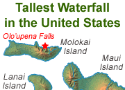
Home » Records » Tallest Waterfalls in the United States
The Tallest Waterfalls in the United States
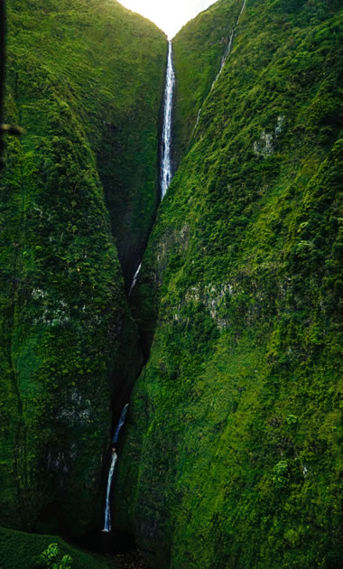
Pu'uka'oku Falls: This photograph shows Pu'uka'oku Falls, located on the north coast of the Island of Molokai, Hawaii. It is believed to be the second tallest waterfall in the United States. Pu'uka'oku Falls is not an uninterrupted vertical drop. Instead the water descends a very steep slope and has a significant amount of contact with bedrock. Olo'upena Falls, the tallest waterfall in the United States is a similar waterfall, located about 1200 feet to the west (see the topographic map below). Image copyright by iStockphoto and Brandon Means.
The Tallest Waterfalls in America
The three tallest waterfalls in the United States are in the Hawaiian Islands. The two tallest, Olo'upena Falls and Pu'uka'oku Falls, both descend the same steep cliff into the Pacific Ocean on the north coast of the Island of Molokai.
The third tallest, Waihilau Falls, descends into a deep valley on the Island of Hawaii. The fourth and fifth tallest are Colonial Creek Falls and Johannesburg Falls, both in the State of Washington.
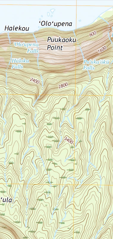
Topographic Map of Olo'upena Falls and Pu'uka'oku Falls: The image above is a portion of the Kamalo, Hawaii 7.5-minute topographic quadrangle published by the United States Geological Survey. It shows the streams that host Olo'upena, Pu'uka'oku, and Hāloku Falls. The original map is at a scale of 1:24,000 and has a contour interval of 40 feet. [2] If you would like to examine the original 1:24,000 map, a link is provided in the reference box at the bottom of this page. Warning: the map file is over 38 megabytes in size and will require several minutes to download on many connections. It is not recommended for use on mobile phones!
1) Olo'upena Falls, Hawaii
Total Height: 2953 feet
Olo'upena Falls is a waterfall located on the island of Molokai, in Maui County, Hawaii. It is believed to be the waterfall in the United States with the greatest total height. It descends a reported vertical distance of 2953 feet (900 meters) down the steep slopes on the north coast of Molokai. [1]
The accompanying image is a portion of the United States Geological Survey (USGS) topographic map for Kamalo, Hawaii. [2] It shows the unnamed stream that hosts Olo'upena Falls.
The stream starts its steep descent at an elevation of approximately 3000 feet above sea level, so a total waterfall height of 2953 feet is possible. We were unable to find any information about who determined the height and how it was determined.
2) Pu'uka'oku Falls, Hawaii
Total Height: 2756 feet
The slopes on the northern coast of Molokai host some of the world's tallest waterfalls. A short distance east of Olo'upena Falls is Pu'uka'oku Falls, which is believed to be the second-tallest waterfall in the United States (another estimated total height: 2756 feet / 840 meters). [1]
Pu'uka'oku Falls is also shown in the accompanying portion of the Kamalo, Hawaii topographic map. It is located a short distance to the east of Olo'upena Falls.
A total height of 2756 feet is possible for Pu'uka'oku Falls because the stream appears to begin its steep descent at an elevation of approximately 2800 feet. Like Olo'upena Falls, we were unable to find any information about how this height was determined.
On the topographic map you can see that USGS shows these streams with the intermittent symbol (blue lines broken by sections consisting of three dots). The name "intermittent" means that these streams do not flow continuously throughout the year. In this case, the streams flow during and after precipitation events of sufficient volume to produce stream runoff. They may also be partially sustained by spring discharge. At other times the streams do not flow.
The higher elevations of Molokai, where these streams originate, receive a mean annual rainfall of between 80 and 140 inches per year. [3] This is much more precipitation than most other parts of the United States. USGS has used the "wooded swamp" symbol throughout the headwaters area.
The headwaters area of these streams is small, and the distance between the headwaters and the knickpoints of the falls is less than two miles. Heavy precipitation in the headwaters area likely produces an almost instantaneous flow of water over the falls. Within a few hours after the precipitation slows or stops, the flow of water over the falls will start to decline.
To view the nearest stream gage (at Halawa Stream on the eastern point of Molokai), visit the USGS stream gaging site. This gage is in a different drainage basin but demonstrates the dramatic response of local streams to episodes of heavy precipitation. [4]
Olo'upena Falls and Pu'uka'oku Falls are not easy to access by land. They are located in a remote area of Molokai covered with dense vegetation. There are no roads or maintained trails within miles of the falls. The only way to obtain a good view of these waterfalls is by chartered helicopter flight or boat.
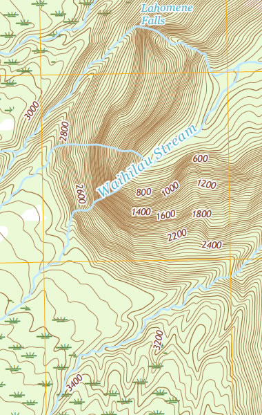
Topographic Map of Waihilau Falls: The image above is a portion of the Kamuela, Hawaii 7.5-minute topographic quadrangle published by the United States Geological Survey. It shows the area surrounding Waihilau Falls. The original map is at a scale of 1:24,000 and has a contour interval of 40 feet. [5] If you would like to examine the original 1:24,000 map, a link is provided in the reference box at the bottom of this page. Warning: the map file is over 38 megabytes in size and will require several minutes to download on many connections. It is not recommended for use on mobile phones!
3) Waihilau Falls, Hawaii
Total Height: 2600 feet
Waihilau Falls is the third-tallest waterfall in the United States. It is located in the Waimanu Valley on the Island of Hawaii. It has an estimated total height of 2600 feet (792 meters). [1]
This is another waterfall that is not easy to visit. There is no paved road and no maintained trail to assist a person in getting to the falls.
The accompanying image is a portion of the United States Geological Survey (USGS) topographic map for Kamuela, Hawaii. [5] It shows the end of the blind valley that hosts Waihilau Falls, Lahomene Falls, and another unnamed waterfall.
Waihilau Stream starts its steep descent at an elevation of about 3000 feet above sea level, so a total waterfall height of 2600 feet is possible. We were unable to find any information about how this height was determined.

Topographic Map of Colonial Creek Falls: The image above shows the full length of Colonial Creek, from where it spills over a drainage divide near the Colonial Glacier to its mouth on Thunder Arm of Diablo Lake. The stream crosses the boundary between the Diablo Dam and the Ross Dam 7.5-minute topographic quadrangles published by the United States Geological Survey. The two maps have been spliced together to produce the image; please click the image for a larger view. The original maps are at a scale of 1:24,000 and have a contour interval of 40 feet. [6] [7] If you would like to examine the original maps, links are provided in the reference box at the bottom of this page. Warning: the map files are each over 80 megabytes in size and will require several minutes to download on many connections. They are not recommended for use on mobile phones!
4) Colonial Creek Falls, Washington
Total Height: 2568 feet
With a total height of 2568 feet, Colonial Creek Falls is the fourth-tallest waterfall in the United States. It is also the tallest waterfall in the continental United States. [1]
It is located in Whatcom County, Washington on a stream named Colonial Creek. The waterfall begins as a lake in contact with the Colonial Glacier, overflows a drainage divide, and descends, mainly as a steep cascade, down bedrock slopes and into the Thunder Arm portion of Diablo Lake.
Colonial Creek Falls spans across two United States Geological Survey 7.5-minute series topographic maps. These are the Diablo Dam Quadrangle [6] and the Ross Dam Quadrangle. Both of these maps have a scale of 1:24,000. They can be downloaded for viewing using the links in the reference box at the bottom of this page. Warning: these are very large map files that will require several minutes to download - they are not recommended for viewing on mobile phones.
| Waterfall Information |
|
[1] World Waterfall Database: by Bryan Swan and Dean Goss, last accessed September 2022.
[2] Kamalo Quadrangle: a 7.5-minute series topographic map, published by the United States Geological Survey, 2017. Attention: This is a 38-megabyte map file and will take several minutes to download - not recommended for viewing on mobile phones. [3] Online Rainfall Atlas of Hawai'i: by Giambelluca, T.W., Q. Chen, A.G. Frazier, J.P. Price, Y.-L. Chen, P.-S. Chu, J.K. Eischeid, and D.M. Delparte, Bulletin of the American Meteorological Society 94, 313-316, 2013. Hosted on the Internet Archive. [4] Online Gaging Station for Halawa Stream, Molokai, Hawaii: by the United States Geological Survey, last accessed September 2022. [5] Kamuela Quadrangle: a 7.5-minute series topographic map, published by the United States Geological Survey, 2017. Attention: This is a 41-megabyte map file and will take several minutes to download - not recommended for viewing on mobile phones. [6] Diablo Dam Quadrangle: a 7.5-minute series topographic map, published by the United States Geological Survey, 2020. Attention: This is an 89-megabyte map file and will take several minutes to download - not recommended for viewing on mobile phones. [7] Ross Dam Quadrangle: a 7.5-minute series topographic map, published by the United States Geological Survey, 2020. Attention: This is a 81-megabyte map file and will take several minutes to download - not recommended for viewing on mobile phones. |
| More Earth Extremes |
 |
The World*s Largest Highly Acidic Lake |
 |
The Tallest Waterfall in the U.S. |
 |
The Most Explosive Eruption |
 |
Largest Volcano - |
 |
Angel Falls |
 |
Deepest Lake in the World |
 |
Bathyscaphe Trieste |
 |
World Record Lightning |

Find Other Topics on Geology.com:

|

| ||

|

| ||

|

| ||

|

|