Home » Earthquakes » New Madrid Seismic Zone
Earthquake Hazard in the New Madrid Seismic Zone
Scientists remain concerned about a major destructive earthquake
Republished from United States Geological Survey Fact Sheet 2009-3071 of August 2009.
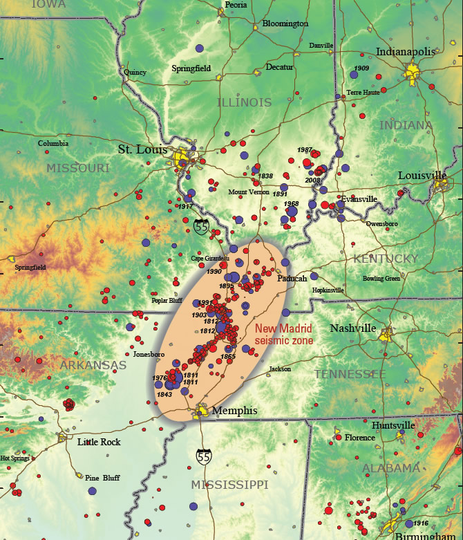
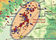
| New Madrid Seismic Zone Map |
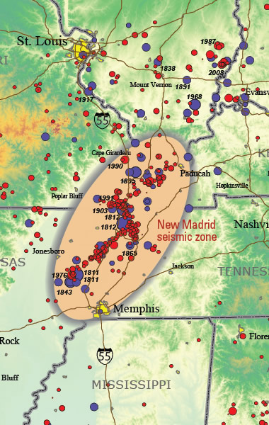
New Madrid earthquake map: Topographic map showing earthquakes greater than magnitude 2.5 (circles) of the central United States. Red circles are earthquakes that occurred after 1972 from the USGS Preliminary Determination of Epicenters catalog. Blue circles are earthquakes that occurred before 1973 from the USGS Preliminary Determination of Epicenters catalog and historical catalog. Larger earthquakes are represented by larger circles. Yellow patches show urban areas with populations greater than 10,000. USGS image. Enlarge map.
| About two hundred years ago three of the most powerful earthquakes in the recorded history of North America occurred along the Mississippi River in southeastern Missouri. They shook the Mississippi Valley and much of eastern United States on December 16, 1811; January 23, 1812; and February 7, 1812 with estimated magnitudes between 7.0 and 8.0. |
Vulnerable Communities in the Mississippi Valley
There is broad agreement in the scientific community that a continuing concern exists for a major destructive earthquake in the New Madrid seismic zone. Many structures in Memphis, Tenn., St. Louis, Mo., and other communities in the central Mississippi River Valley region are vulnerable and at risk from severe ground shaking. This assessment is based on decades of research on New Madrid earthquakes and related phenomena by dozens of Federal, university, State, and consulting earth scientists.
Considerable interest has developed recently from media reports that the New Madrid seismic zone may be shutting down. These reports stem from published research using global positioning system (GPS) instruments with results of geodetic measurements of strain in the Earth’s crust. Because of a lack of measurable strain at the surface in some areas of the seismic zone over the past 14 years, arguments have been advanced that there is no buildup of stress at depth within the New Madrid seismic zone and that the zone may no longer pose a significant hazard.
As part of the consensus-building process used to develop the national seismic hazard maps, the U.S. Geological Survey convened a workshop of experts in 2006 to evaluate the latest findings in earthquake hazards in the Eastern United States. These experts considered the GPS data from New Madrid available at that time that also showed little to no ground movement at the surface. The experts did not find the GPS data to be a convincing reason to lower the assessment of earthquake hazard in the New Madrid region, especially in light of the many other types of data that are used to construct the hazard assessment, several of which are described here.
The Geological Record
There are historical accounts of major earthquakes in the New Madrid region during 1811-12. The geologic record of pre-1811 earthquakes also reveals that the New Madrid seismic zone has repeatedly produced sequences of major earthquakes, including several of magnitude 7 to 8, over the past 4,500 years. These prehistoric earthquakes caused severe and widespread ground failures in the New Madrid region, much like those caused by the 1811-12 earthquake sequence. The key evidence for large earthquakes that occurred in the past are sand blows that formed when underground sand and water erupted to the surface as a result of violent shaking. Numerous large sand blows over a wide area were created by strong ground shaking during the 1811-12 earthquakes. Similarly large, widespread, and abundant prehistoric sand blows were produced over the same area during ground shaking from previous clusters of large earthquakes around A.D. 1450, A.D. 900, and 2350 B.C. The sizes and areal distribution of the prehistoric sand blows indicate that the older earthquakes were similar in location and magnitude to the 1811-12 shocks.
Continuing Seismic Activity
The New Madrid seismic zone is a source of continuing small and moderate earthquakes, which attest to the high stress in the region and indicate that the processes that produced the large earthquakes over the previous 4,500 years, are still operating. It is the most seismically active area of the United States east of the Rockies. There is no sign that the rate of these smaller earthquakes is decreasing with time, as would be expected if they were aftershocks of the 1811–12 earthquakes.
GPS Data From the New Madrid Seismic Zone
It has been known for several years that GPS measurements made since about 1996 do not show significant deformation across part of the New Madrid seismic zone. The new results reported on recently are not substantially different from those derived from previous GPS data. These short-term observations, though important, must be tempered by the context of tectonic processes developed over many thousands to millions of years. Such long-term processes are unlikely to switch off in a few decades with an accompanying decrease in the earthquake hazard. The New Madrid region is located in the middle of the vast North American tectonic plate. In contrast to plate boundary settings like the coasts of California or Alaska where continuous deformation can be measured at the surface, some models predict that little deformation will occur during the period between large earthquakes in seismic areas within a plate.
The USGS has carried out an extensive consensus-building process in the development and updating of the national seismic hazard maps. These maps are the basis for the seismic provisions in the model-building codes adopted in almost all of the United States. Many workshops were conducted involving hundreds of scientists and engineers, and a thorough peer review process was undertaken in the development of the seismic hazard maps. Scientists at some workshops evaluated the New Madrid GPS results of the past 12 years and debated their meaning. They also considered the clear geologic evidence of large earthquakes occurring over the past 4,500 years and the continuing moderate earthquakes in the area. It was the consensus of this broad group of scientists that (1) the evidence indicates that we can expect large earthquakes similar to the 1811-12 earthquakes to occur in the future with an average recurrence time of 500 years and that (2) magnitude 6 earthquakes, which can also cause serious damage, can be expected more frequently than the large 1811-12 shocks.
Based on this history of past earthquakes, the USGS estimates the chance of having an earthquake similar to one of the 1811-12 sequence in the next 50 years is about 7 to 10 percent, and the chance of having a magnitude 6 or larger earthquake in 50 years is 25 to 40 percent.
Likely Impacts from Future Large Earthquakes
Earthquake hazards involve more than just strong ground shaking from passing seismic waves. The 1811-12 earthquakes caused many types of ground failures including landslides along the Mississippi River bluffs from Mississippi to Kentucky. Ground failures also included lateral spreading and ground subsidence by soil liquefaction across the Mississippi River flood plain and along tributaries to the Mississippi River over at least 15,000 square kilometers. Today, a repeat event could be expected to produce similar effects in northeastern Arkansas, southeastern Missouri, western Tennessee and Kentucky, and southern Illinois. Roadways in the Mississippi Valley of Arkansas and Missouri (such as Interstate 55) could become impassable because of bridge failures and fissuring of road surfaces. Venting of large quantities of water, sand, and mud as a result of liquefaction could flood fields and roads and disrupt agriculture for weeks to months. Flooding of farmland, where agricultural chemicals are stored onsite, could contaminate rivers and streams. Failure of levees, especially during high water, would contribute to flooding, and failures of riverbanks could make the Mississippi River and its tributaries difficult to navigate for many weeks.
The City of Memphis and the surrounding metropolitan area of more than one million people would be severely impacted. Memphis has an aging infrastructure, and many of its large buildings, including unreinforced schools and fire and police stations, would be particularly vulnerable when subjected to severe ground shaking. Relatively few buildings were built using building codes that have provisions for seismic-resistant design. Soil liquefaction and related ground failures are likely to occur in downtown Memphis along the Mississippi River and along the Wolf River that passes through Memphis. The older highways and railroad bridges that cross the Mississippi River, as well as older overpasses, would likely be damaged or collapse in the event of a major New Madrid earthquake. Some of the bridges and pipelines crossing the Wolf River might be damaged or destroyed. Although Memphis is likely to be the focus of major damage in the region, St. Louis, Mo., Little Rock, Ark., and many small and medium-sized cities would also sustain damage.
The contact person at USGS for New Madrid earthquake studies is Martitia Tuttle, Central and Eastern U.S. Regional Coordinator, Earthquake Hazards Program, U.S. Geological Survey, 3876 Central Avenue, Suite 2, Memphis, Tennessee 38152-3050, phone: 901-678-4974, email: mptuttle@usgs.gov. |
Continuing Preparedness Needed
The geologic record of repeated large earthquakes, the historical accounts of the 1811-12 large earthquakes, and the continuing earthquake activity in the area are compelling evidence that the New Madrid region has high earthquake hazard. The preponderance of evidence leads us to conclude that earthquakes can be expected in the future as frequently and as severely as in the past 4,500 years. Such high hazard requires prudent measures such as adequate building codes to protect public safety and ensure the social and economic resilience of the region to future earthquakes.
| More Earthquakes |
 |
Earthquake Lessons |
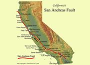 |
What is the San Andreas Fault? |
 |
California Earthquake Maps |
 |
What Causes a Tsunami? |
 |
New Madrid Seismic Zone |
 |
The Japan Earthquake |
 |
Largest Earthquake |
 |
Gifts That Rock |

Find Other Topics on Geology.com:

|

| ||

|

| ||

|

| ||

|

|