Home » World Maps » CIA Map of Africa
CIA Map of Africa
Africa is the world's second-largest and second-most-populous continent.

| This map of Africa was prepared by the United States Central Intelligence Agency (CIA) in January 2015. It was intended for use by government officials and the general public. Maps of Africa are frequently updated to properly show new country names, country divisions, and other political changes. This map shows the new country of South Sudan, which became its own country after obtaining its independence from the Republic of Sudan in 2011. |
ADVERTISEMENT
Where is Africa?


| Map of Africa prepared in April 2018 by the United States Central Intelligence Agency (CIA) for use by government officials and the general public. Maps of Africa are frequently updated to properly show new country names, country divisions, and other political changes. This map updates the new country name for Swaziland. The new name is Eswatini, or more formally, the Kingdom of Eswatini. |
CIA Maps of Africa:
The maps on this page are political maps of Africa published by the United States Central Intelligence Agency, better known as the CIA.The top map was created in January 2015. It was produced using a Robinson Projection with standard parallels at 38 degrees north and 38 degrees south. Because Africa is situated at the intersection of these standard parallels, other parallels appear on these maps as "almost straight lines". Because of that, these maps might be mistaken for having a Mercator cylindrical projection, similar to what has long been used in educational and navigational maps.
The bottom map was created in April 2018. It was produced using an Azimuthal Equal-Area Projection at a scale of 1:51,400,000.
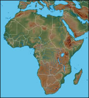
Physical Map of Africa:
This is a physical map of Africa which shows the continent in shaded relief. Mountainous regions are shown in shades of tan and brown, such as the Atlas Mountains, the Ethiopian Highlands, and the Kenya Highlands. You can see that there are many rivers in the Congo Basin of central Africa, while the Sahara Desert region of northern Africa has almost none. Physical features within Africa's Great Rift Valley can be seen on the map, including Lake Tanganyika, Lake Malawi, and Lake Victoria, which are located in the southern portion of the valley.
Explore Africa Using Google Earth:
Google Earth is a free program from Google that allows you to explore satellite images showing the cities and landscapes of Africa and the rest of the world in fantastic detail. It works on your desktop computer, tablet, or mobile phone. The images in many areas are detailed enough that you can see houses, vehicles and even people on a city street. Google Earth is free and easy-to-use.
Africa on a World Wall Map:
Africa is one of 7 continents illustrated on our Blue Ocean Laminated Map of the World. This map shows a combination of political and physical features. It includes country boundaries, major cities, major mountains in shaded relief, ocean depth in blue color gradient, along with many other features. This is a great map for students, schools, offices and anywhere that a nice map of the world is needed for education, display or decor.
Large Wall Map of Africa:
If you are interested in the geography of Africa, our large laminated map of Africa might be just what you need. It is a large political map of Africa that also shows many of the continent's physical features in color or shaded relief. Major lakes, rivers, cities, roads, country boundaries, coastlines and surrounding islands are all shown on the map.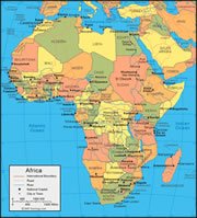
Map of the African Continent:
This map of Africa includes most of the Mediterranean Sea and portions of southern Europe. It also includes most countries of the Middle East. It presents the continent in the form of a Lambert Azimuthal Equal Area Projection. It views the Earth from a point located directly above 10 degrees north latitude and 20 degrees east longitude. It is what you would see from a satellite located immediately above that point and high enough above the Earth to see the entire map area. It is made by projecting all points on Earth's surface up to the satellite and recording them on a horizontal plane that is tangent to Earth's surface directly below the satellite. This type of projection best preserves the relative size and area of features on Earth's surface.
ADVERTISEMENT