Home » World Maps » Africa » Libya
Libya Map and Satellite Image
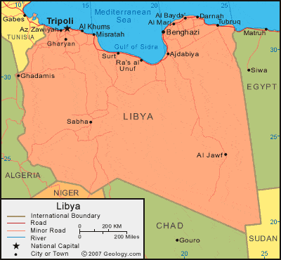
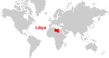
| Libya is located in northern Africa. Libya is bordered by the Mediterranean Sea, Tunisia and Algeria to the west, Niger and Chad to the south, and Egypt and Sudan to the east. |
ADVERTISEMENT
Libya Bordering Countries:
Algeria, Chad, Egypt, Niger, Sudan, TunisiaRegional Maps:
Map of Africa, World MapWhere is Libya?
Libya Satellite Image

ADVERTISEMENT

Explore Libya Using Google Earth:
Google Earth is a free program from Google that allows you to explore satellite images showing the cities and landscapes of Libya and all of Africa in fantastic detail. It works on your desktop computer, tablet, or mobile phone. The images in many areas are detailed enough that you can see houses, vehicles and even people on a city street. Google Earth is free and easy-to-use.
Libya on a World Wall Map:
Libya is one of nearly 200 countries illustrated on our Blue Ocean Laminated Map of the World. This map shows a combination of political and physical features. It includes country boundaries, major cities, major mountains in shaded relief, ocean depth in blue color gradient, along with many other features. This is a great map for students, schools, offices and anywhere that a nice map of the world is needed for education, display or decor.
Libya On a Large Wall Map of Africa:
If you are interested in Libya and the geography of Africa our large laminated map of Africa might be just what you need. It is a large political map of Africa that also shows many of the continent's physical features in color or shaded relief. Major lakes, rivers, cities, roads, country boundaries, coastlines and surrounding islands are all shown on the map.Libya Cities:
Ajdabiya, Al Bayda, Al Jawf, Al Khums, Al Marj, As Sidr, Az Zawiyah, Banghazi (Benghazi), Bani Walid, Darnah (Derna), Dirj, Ghadamis, Gharyan, Leptis Magna (Labdah), Misratah, Qaminis, Ra's al Unuf, Sabha, Surt (Sidra), Tarabulus (Tripoli), Tubruq (Tobruk), Zlitan and Zuwarah.Libya Locations:
Al Haruj al Aswad, Al Kufrah (Kufra Oasis), Jabal as Sawda, Khalij al Bumah, Khalij Surt (Gulf of Sidra), Libyan Plateau (Ad Diffah), Mediterranean Sea, Sahra Awbari, Sahra Marzuq, Sahra Rabyanah, Sarir Kalanshiyu ar Ramli al Kabir (Sand Sea of Calanscio) and Sarir Kalanshiyu.Libya Natural Resources:
Libya has fossil fuel deposits which include petroleum and natural gas. Another resource found in this country is the mineral gypsum.Libya Natural Hazards:
Libya is subject to natural hazards, which include dust storms, sandstorms, and the hot, dry, dust-laden ghibli, which is a southern wind that lasts one to four days in the spring and fall.Libya Environmental Issues:
The country of Libya has very limited natural fresh water resources. However, the Great Man-Made River Project was built to transfer water to the coastal cities from large aquifers under the Sahara. It is the largest water development project in the world. Another environmental issue for Libya is desertification.
ADVERTISEMENT