Home » World Maps » North America » Caribbean Islands » Leeward and Windward Islands
Leeward Islands Map - Windward Islands Map - Satellite Image

|
What are the Windward Islands? The Windward Islands are located on the eastern edge of the Caribbean Sea and form the southeastern boundary between the Caribbean and the Atlantic Ocean. The Windward group includes the islands of Martinique, St. Lucia, St. Vincent and the Grenadines, and Grenada. Some geographers include Barbados and Trinidad and Tobago in the Windward Islands.
What are the Leeward Islands? The Leeward Islands are located on the eastern edge of the Caribbean Sea and form the northeastern boundary between the Caribbean and the Atlantic Ocean. The Leeward group includes: the U.S. Virgin Islands, the British Virgin Islands, Anguilla, Saint Martin, Saint-Barthelemy, Saba, Sint Eustatius, Saint Kitts, Nevis, Barbuda, Antiqua, Redonda, Montserrat and Guadeloupe. What are the Leeward Antilles? The Leeward Antilles is a chain of islands in the southern Caribbean Sea off the coast of Venezuela. They include Aruba, Curacao, Bonaire, Isla la Tortuga and Isla la Margarita. Map from the Central Intelligence Agency. |
ADVERTISEMENT
Regional Maps:
Caribbean Islands, Barbados, Grenada, North America, World MapWhere are the Windward and Leeward Islands?
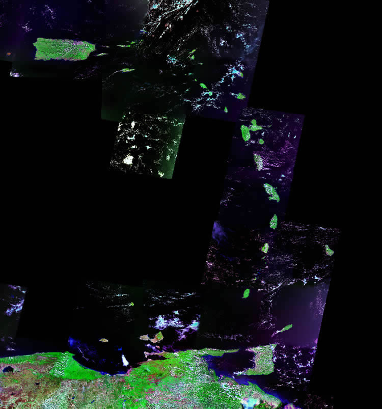
Windward and Leeward Islands Satellite Image
ADVERTISEMENT

Political Map of the Caribbean:
This is a political map of the Caribbean which shows the countries and islands of the Caribbean Sea along with capital cities and major cities. The map is a portion of a larger world map created by the Central Intelligence Agency using Robinson Projection. You can also view the full pan-and-zoom CIA World Map as a PDF document.
Explore Caribbean Islands Using Google Earth:
Google Earth is a free program from Google that allows you to explore satellite images showing the cities and landscapes of Caribbean Islands and the rest of the world in fantastic detail. It works on your desktop computer, tablet, or mobile phone. The images in many areas are detailed enough that you can see houses, vehicles and even people on a city street. Google Earth is free and easy-to-use.
Caribbean Islands on a World Wall Map:
The Caribbean Islands contain several of nearly 200 countries illustrated on our Blue Ocean Laminated Map of the World. This map shows a combination of political and physical features. It includes country boundaries, major cities, major mountains in shaded relief, ocean depth in blue color gradient, along with many other features. This is a great map for students, schools, offices and anywhere that a nice map of the world is needed for education, display or decor.
Caribbean Islands On a Large Wall Map of North America:
If you are interested in the Caribbean Islands and the geography of North America, our large laminated map of North America might be just what you need. It is a large political map of North America that also shows many of the continent's physical features in color or shaded relief. Major lakes, rivers, cities, roads, country boundaries, coastlines and surrounding islands are all shown on the map.How were Windward and Leeward named?
Early sailing ships crossing the Atlantic took advantage of the trade winds and ocean currents. These often delivered them to the edge of the Caribbean Sea near Dominica and Martinique. The Windward Islands were named because they were more windward at this location than the Leeward Islands.Geologic Setting:
The Windward and Leeward Islands are positioned on the eastern edge of the Caribbean Plate. This is an area of modern and historic volcanism. The islands are mainly volcanic with some coral contributions. They have a rich volcanic soil that supports a small agricultural economy.Economy:
The Windward and Leeward Islands have a warm, mild climate and are frequent stops of the Caribbean cruise industry. Tourism is their most important source of outside income. They have a small agricultural economy, and crops such as bananas, spices, limes, sugar, cotton, coffee, tobacco, and cacao are grown for export.
ADVERTISEMENT