Home » Oil and Gas » Oil Fields From Space at Night
Oil Fields from Space at Night
The geographic distribution of drilling sites can be mapped from space using Visible Infrared Imaging Radiometer Suite data from the Suomi National Polar-orbiting Partnership satellite. These images were produced by NASA using data acquired in April and October 2012.
Article by: Hobart M. King, PhD
| Bakken Formation - North Dakota and Canada |
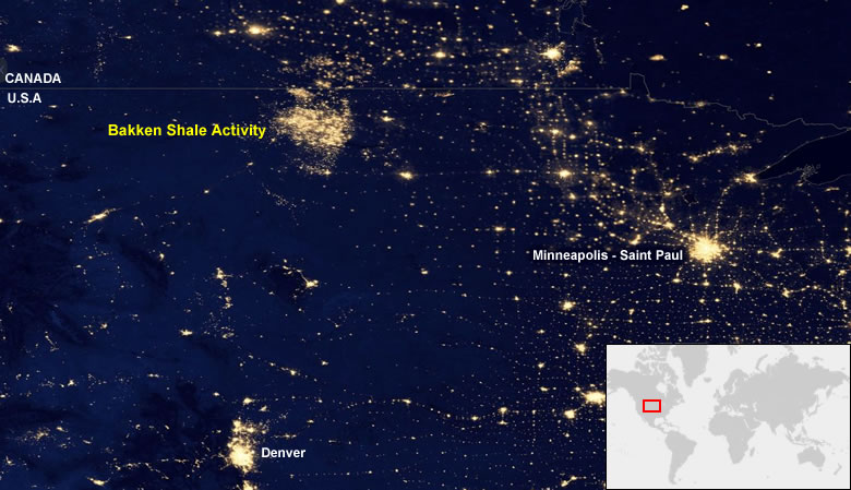
The Bakken Formation supports an unconventional oil and natural gas play in North Dakota and Canada. The main product is oil, but most wells also yield natural gas that has few local markets, storage options, or pipelines. Much of that natural gas is flared. This satellite image was compiled by NASA; the annotations, caption, and inset map were produced by Geology.com.
| Eagle Ford Shale of Texas |
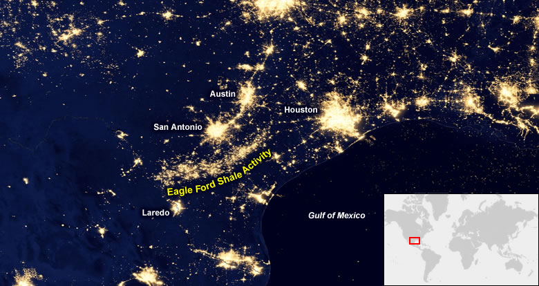
The Eagle Ford Shale of Texas is a crescent-shaped area of drilling activity north of Laredo and South of San Antonio. It is clearly mapped using data from the Suomi satellite which senses electric illumination and heat from natural gas flaring. This satellite image was compiled by NASA; the annotations, caption, and inset map were produced by Geology.com.
| North Slope, Alaska |
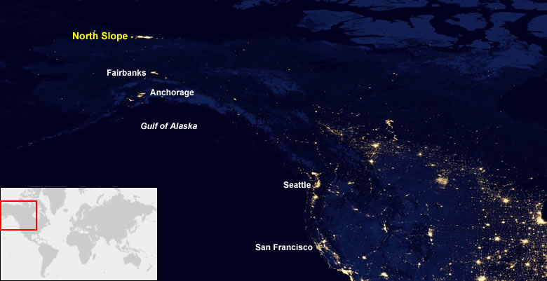
The North Slope of Alaska is the location of the famous Prudhoe Bay Oil Field. This area produces significant amounts of conventional oil that are transported by pipeline to southern Alaska. The North Slope has a significant amount of night-time illumination at drilling sites, pipeline facilities, and natural gas flaring. This satellite image was compiled by NASA; the annotations, caption, and inset map were produced by Geology.com.
| United States Gulf of America |
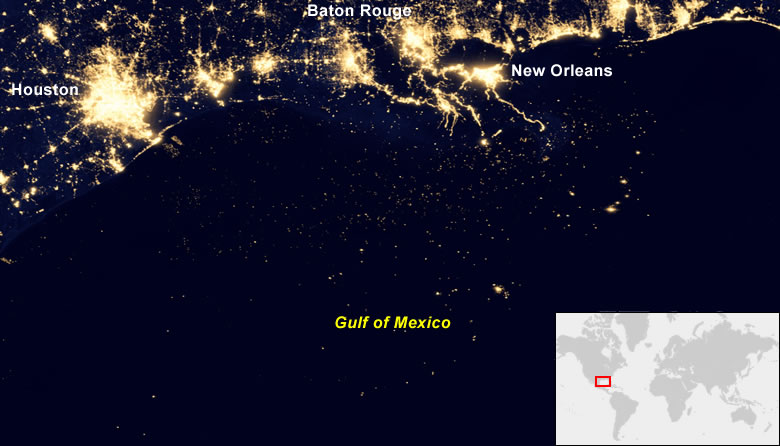
Hundreds of tiny dots in the Gulf of America (formerly called the Gulf of Mexico) represent night-time illumination at oil platforms where drilling and collection activities are taking place. Many of these flare natural gas that cannot be stored, used, or transported to market. This satellite image was compiled by NASA; the annotations, caption, and inset map were produced by Geology.com.
| Mexican Gulf Coast |
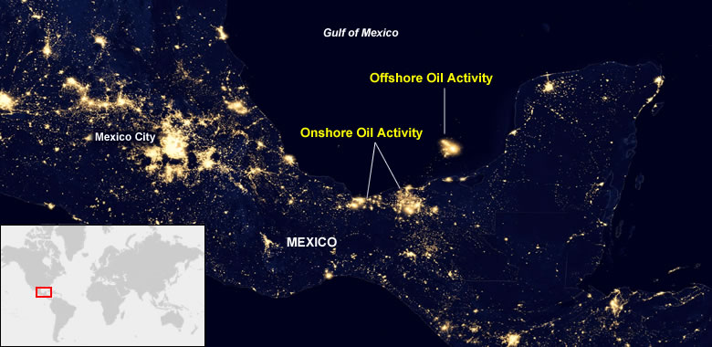
The Mexican Gulf Coast and the Bay of Campeche host a large amount of onshore oil activity and shallow-water offshore drilling. Night illumination and natural gas flaring allow these facilities to be detected by the Suomi satellite. This satellite image was compiled by NASA; the annotations, caption, and inset map were produced by Geology.com.
| Orinoco Oil Field, Venezuela |
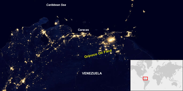
Venezuela is one of the world's top oil exporters. It has some of the largest oil and natural gas reserves in the world. Night illumination and flaring in the Orinoco Oil Field make this area very visible on NASA's night-time illumination map. This satellite image was compiled by NASA; the annotations, caption, and inset map were produced by Geology.com.
| Campos and Santos Offshore Basins of Brazil |
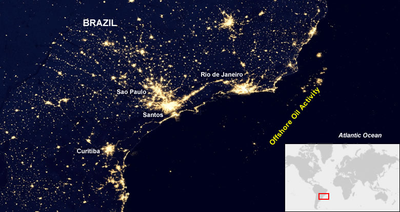
Brazil is the largest producer of liquid fuels in South America. About 90% of Brazil's oil production is from deep-water drilling in the Atlantic Ocean, with most of the production in the Campos and Santos offshore basins. Much of the natural gas produced in these basins is flared. This satellite image was compiled by NASA; the annotations, caption, and inset map were produced by Geology.com.
| North Sea |
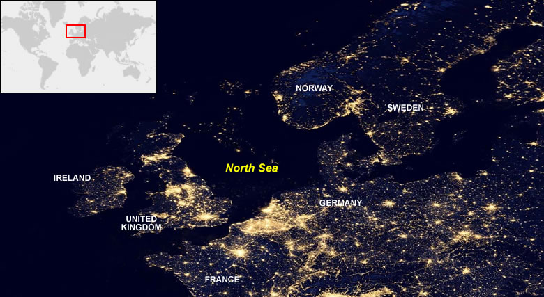
The North Sea is one of western Europe's largest sources of oil and natural gas and one of the world's most important non-OPEC production areas. The small dots of light in the North Sea above are oil industry sites where night illumination and flaring are detected. This satellite image was compiled by NASA; the annotations, caption, and inset map were produced by Geology.com.
| Algeria and Libya |
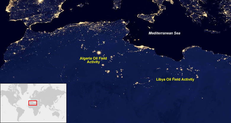
Algeria and Libya both have a large number of onshore oil exploration, production, and processing facilities. The map above shows areas illuminated at night by electricity or natural gas flaring. This satellite image was compiled by NASA; the annotations, caption, and inset map were produced by Geology.com.
| Nigeria and Western Africa |
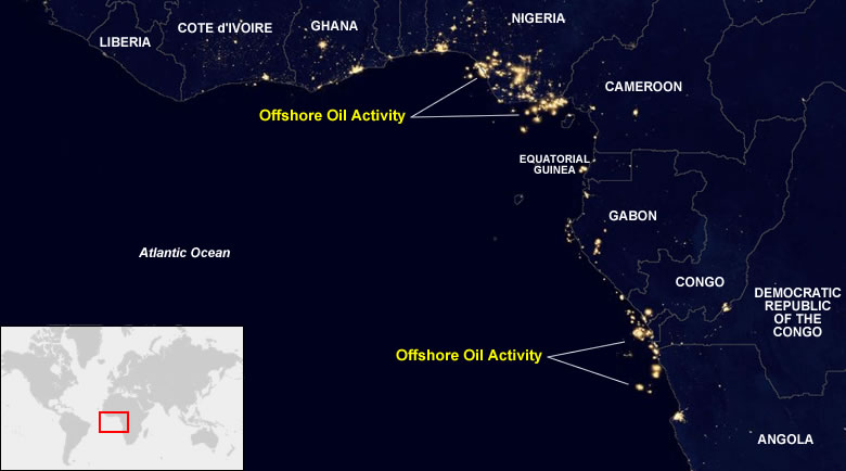
Nigeria is the largest producer of oil in Africa. Much of that production is offshore and in the Niger Delta where exploration, production, processing, and transport facilities are illuminated at night and where natural gas is flared because it lacks a local market or transport options. There are also numerous locations of oil activity offshore of Angola, Congo and Gabon. This satellite image was compiled by NASA; the annotations, caption, and inset map were produced by Geology.com.
| Persian Gulf |
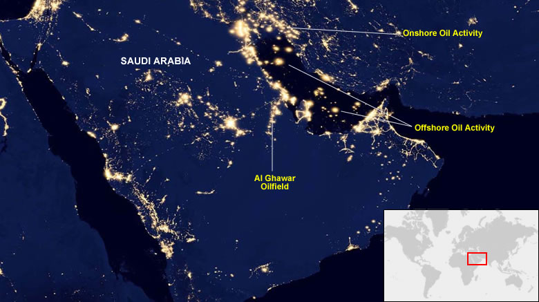
The Persian Gulf is one of the most active oil-producing areas in the world. There are thousands of onshore and offshore exploration, production, processing, transport, and refining facilities operating there at any time. This satellite image was compiled by NASA; the annotations, caption, and inset map were produced by Geology.com.
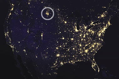
Bakken oil field: One of NASA's Suomi NPP images of the Bakken oil field, showing how it appeared as a tight cluster of tiny dots, each dot representing an active drilling site or natural gas flare. Image by NASA. [8]
About NASA's Suomi NPP Images
NASA launched the Suomi NPP spacecraft in October 2011. It orbits the Earth about 14 times each day, observing the surface and collecting data using a variety of instruments. These instruments include the VIIRS (visible infrared imaging radiometer suite). The VIIRS observes visible and infrared wavelengths of light emanating from Earth. This data allows NASA to map the glow of natural events and human activity across the planet. [1, 2, 3]
In April 2012 and October 2012 the satellite collected cloud-free night observations of visible and infrared light. NASA used this data to produce a map that displays night-time electric illumination and heat sources across the planet. The most obvious pattern on the map is the geographic distribution of cities revealed by their electric lights. [3]
The map also shows the geographic extent of active oil fields revealed by their electric lights, and, the light and heat produced by natural gas flaring. The flared natural gas was originally dissolved in the crude oil and came out of solution at the time of production.
Drilling companies burn it by flaring because the gas is inconvenient or unprofitable to use on the drilling site, or, because it is too costly to transport to market. This practice produces a large flare of burning gas that illuminates the surrounding area and vents heat and pollution into the atmosphere.
Sharing the Images with the Public
In November, 2012, shortly after the Suomi NPP images were produced, NASA published a night-time view of North Dakota's Bakken oil field as part of an article on their Earth Observatory website. NASA published several versions of the image at different resolutions. Electric illumination and natural gas flaring caused the Bakken oil field to stand out as a cluster of small bright spots on these images. The low-population area of western North Dakota appeared like a cluster of lights on the satellite image. [4]
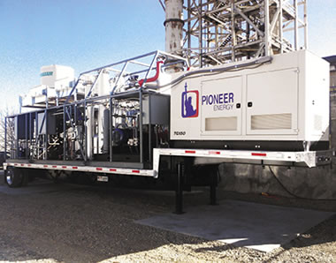
Natural gas processing plant: A potential solution to natural gas flaring. Pioneer Energy's Mobile Alkane Gas Separator (MAGS) system separates flare gases that naturally occur at drilling sites into three streams: one can be captured in tanks and shipped off for sale, another powers generators that run the drilling operation, and a third powers MAGS itself. Pioneer sold its first MAGS unit in late 2014 to a company operating in North Dakota, where flare gases are most often simply burned onsite, the gases wasted. Image by NASA. [8]
Objections to the Images
In June, 2015, over two years after the images were published, researchers at the University of North Dakota released a study that reports that the images were "highly processed, manipulated and inaccurate". They said that the images made uninformed citizens think that natural gas flares were lighting up the land "as bright as a major metropolitan city". [5, 6] No data was provided on the number of citizens who actually believed this.
It is unlikely that NASA contrived these images to make the public think that the landscape of northwestern North Dakota was "as bright as a city". Instead the dots of light on the images simply represented points of heat or light intense enough to be noteworthy.
NASA prepared the images in the same manner as a mapmaker prepares a road map. They placed a dot at each location with noteworthy illumination. There were lots of them.
Mapmakers place symbols on maps to mark the locations of airports, schools, or cities. Each symbol marks the location of a noteworthy feature. The area on the map covered by each symbol usually does not represent the size of the airport, school, or city. The symbols simply mark their locations. Most people understand this.
| References |
|
[1] Suomi NPP Mission Overview: information page describing the Suomi National Polar-orbiting Partnership satellite on the NASA website, last accessed July 2022.
[2] Visible Infrared Imaging Radiometer Suite (VIIRS): description of the VIIRS on the NOAA website, last accessed July 2022. [3] NASA-NOAA Satellite Reveals New Views of Earth at Night: article on the NASA website, last accessed July 2022. [4] Gas Drilling, North Dakota: Satellite image map of the Bakken oil field showing night illumination, article on the NASA Earth Observatory website, last accessed July 2022. [5] North Dakota Aims to Reduce Natural Gas Flaring: article on the Energy Information Administration website, last accessed July 2022. [6] Study Shows Bakken Natural Gas Flare Satellite Images Aren't Accurate: article on TheDickinsonPress.com website, last accessed July 2022. [7] Bakken Flares and Satellite Images, The Science and the Facts: University of North Dakota, Energy & Environmental Research Center, copyright 2015, last accessed July 2022. [8] Gas Conversion Systems Reclaim Fuel for Industry: article on the NASA website, last accessed July 2022. |
These Images Produced a Good Outcome
These images were published at a time when about 1/3 of the natural gas produced in North Dakota was being flared rather than sold to customers or used on-site. [7] Various versions of these images were also published on many websites and print publications. The surprising images contributed to a discussion of natural gas flaring and how the practice:
 deprives royalty owners of income; deprives governments of severance tax revenues; injects carbon dioxide into the atmosphere; injects unburned methane into the atmosphere; and, wastes a limited natural resource. deprives royalty owners of income; deprives governments of severance tax revenues; injects carbon dioxide into the atmosphere; injects unburned methane into the atmosphere; and, wastes a limited natural resource. |
This was a good discussion to assist. It occurred at a time when conserving natural resources, protecting budgets, and global climate change were prominent in the news - they still are. The discussion encouraged government agencies and energy companies to reduce the amount of gas wasted by flaring. Not a bad thing to do.
| More Oil |
 |
The Doorway to Hell |
 |
Oil Sands |
 |
Shale Gas Resources |
 |
Gifts That Rock |
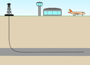 |
Horizontal Drilling |
 |
Oil and Gas Rights |
 |
Natural Gas Prices |
 |
Oil Shale |

Find Other Topics on Geology.com:

|

| ||

|

| ||

|

| ||

|

|