Home » US Maps » West Virginia » Lakes and Rivers
West Virginia Lakes, Rivers and Water Resources

ADVERTISEMENT
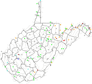
West Virginia Rivers Shown on the Map: Big Coal River, Big Sandy River, Cacapon River, Elk River, Gauley River, Green Brier River, Guyandotte River, Little Kanawha River, Middle Island Creek, Monongahela River, New River, North Branch Potomac River, North Fork, Ohio River, Potomac River, South Branch Potomac River, South Fork, Tug Fork, Tygart Valley River and West Fork River.
West Virginia Lakes Shown on the Map: Bluestone Lake, Summersville Lake, Sutton Lake and Tygart Lake.
| West Virginia Stream and River Levels |
 The United States Geological Survey has a number of stream gages located throughout West Virginia. These estimate stream levels, discharges and record them over time. This data is published on the web and many stations allow users to plot custom graphs. Get updated West Virginia river and stream levels from USGS here.
| West Virginia Stream and River Level Alerts |
 The United States Geological Survey has a system that will send you an email message when flood levels are reached on any stream with USGS gaging equipment that you have selected. Sign up here to receive West Virginia stream and river level alerts.
| West Virginia Water Publications |
 The United States Geological Survey has a number of publications related to water use and water resources in West Virginia. Visit the Virginia and West Virginia Water Science Center here.

| West Virginia Waterfall: Blackwater Falls |
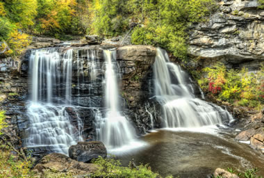 Blackwater Falls is located in Blackwater Falls State Park in the Allegheny Mountains of West Virginia, where Blackwater River enters Blackwater Canyon. This well-known cascade waterfall is approximately 62 feet high. The river was named due to its coloration, caused by the tannins of local plants. Image copyright by iStockphoto / ablokhin.
| West Virginia Drought Map |
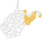 The United States Geological Survey publishes updated drought maps on their website. There you can view a map that shows where below normal 7-day average stream flow conditions were recently recorded. The maps are updated daily. Get a current West Virginia drought map here.
| West Virginia Elevation Map |
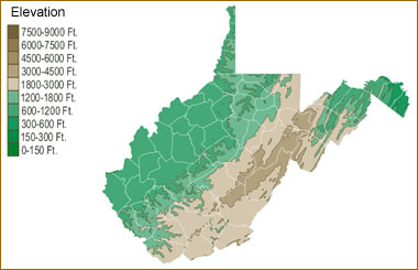 The topography of an area determines the direction of stream flow and often is a primary influence on the geographic distribution of precipitation. View a detailed West Virginia elevation map.


Find Other Topics on Geology.com:

|

| ||

|

| ||

|

| ||

|

|