Home » Landslides » Saidmarreh Landslide
The Saidmarreh Landslide
This ancient landslide in Iran moved about five cubic miles of material.
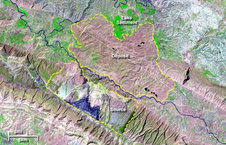
Saidmarreh Landslide: Landsat image of Saidmarreh Landslide in Saidmarreh, Iran. The source area of the slide is bounded on the southwest by the crest of the Kabir Kuh anticline. Debris from the slide travelled down the flank of the anticline, across the Karkheh River and continued across the valley floor. Some material in the slide was carried a distance of 14 kilometers (9 miles). Enlarge image.
The Saidmarreh Slide
|

One of the largest landslides that can be easily recognized on satellite images is the Saidmarreh Landslide in western Iran. The slide occurred about 10,000 years ago, when about 20 cubic kilometers (about 5 cubic miles) of Lower Miocene and Eocene limestone detached along bedding planes and slipped down the north flank of the Kabir Kuh anticline. The maximum vertical descent was about 1600 meters (5250 feet).
The sliding slab was about 15 kilometers (9 miles) wide and had a surface area of about 165 kilometers (64 square miles). Debris from the slide crossed the Karkheh River at the base of the slope and spread across the valley floor. Some material in the slide had a travel distance of over 14 kilometers (9 miles).
Related: The World's Largest Landslides
| Saidmarreh Landslide Information |
|
[1] Shoaei, Z. and Ghayoumian, J., 1998, Seimareh landslide, the largest complex slide in the world, In: Moore D. and Hungr O. (editors), Eighth International Congress of the International Association for Engineering Geology and the Environment, Proceedings, Pages 1337-1342.
[2] Harrison, J.V. and Falcon, N.L., 1938, An Ancient Landslip at Saidmarreh in Southwestern Iran, The Journal of Geology, Volume 46, pages 296-309. [3] Dave Petley, 2009, The biggest landslide of them all - Saidmareh, Iran, The Landslide Blog. Last accessed August 2022. |
The slide debris dammed the Karkheh River, causing a large lake to form behind the dam. The lake persisted long enough for up to 150 meters of sediment to accumulate on its bottom (these sediments currently support several thousand acres of cultivated land). The lake then breached the dam and eroded a channel through it. The current landscape is shown in the Landsat image at the top of this page and in the Google satellite image.
Author: Hobart M. King, Ph.D.
| More Landslides |
 |
Landslides |
 |
Debris Flows |
 |
Yosemite Rockfall Photos |
 |
Largest Landslides |
 |
Lahars |
 |
Gifts That Rock |
 |
Largest Tsunami |
 |
Yosemite Rockfall Hazards |

Find Other Topics on Geology.com:

|

| ||

|

| ||

|

| ||

|

|