Home » Plate Tectonics » Plate Tectonics Map
Plate Tectonics Map - Plate Boundary Map
Article by: Hobart M. King, PhD

According the theory of plate tectonics, Earth's outer shell is made up of a series of plates. The map above shows names and generalized locations of Earth's major tectonic plates. These plates move and interact with one another to produce earthquakes, volcanoes, mountain ranges, ocean trenches and other geologic processes and features. Map prepared by the United States Geological Survey.
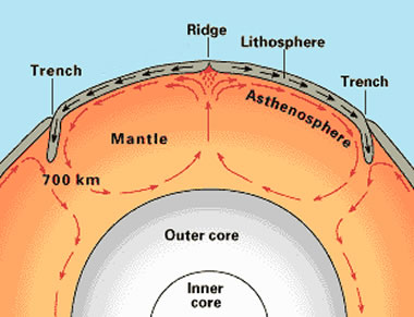
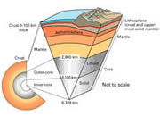
Creation and Destruction of Lithosphere: New lithosphere is created at mid-ocean ridges where plates pull apart and molten material escapes as a subsea fissure eruption. Lithosphere is destroyed near ocean trenches, where lithospheric plates descend into the mantle and are assimilated into the mantle. Image by the United States Geological Survey.
Earth's Major Tectonic Plates
The outermost part of Earth's structure is known as the lithosphere. The lithosphere consists of the crust and small portion of the upper mantle. The lithosphere is divided into a number of tectonic plates. These plates move and interact with one another, driven by convectional forces within the Earth. The map at the top of this page shows the geographic location and extent of 15 major lithospheric plates.
Table of Contents
 List of Major Lithospheric Plates Plate Boundaries Mid-Ocean Ridges Ocean Trenches Poorly Defined Boundaries More Plate Tectonics Maps List of Major Lithospheric Plates Plate Boundaries Mid-Ocean Ridges Ocean Trenches Poorly Defined Boundaries More Plate Tectonics Maps |
List of Major Lithospheric Plates
This is a list of the 15 major tectonic plates shown on the map at the top of this page:
|
African Plate Antarctic Plate Arabian Plate Australian Plate Caribbean Plate Cocos Plate Eurasian Plate Indian Plate Juan de Fuca Plate Nazca Plate North American Plate Pacific Plate Philippine Plate Scotia Plate South American Plate |
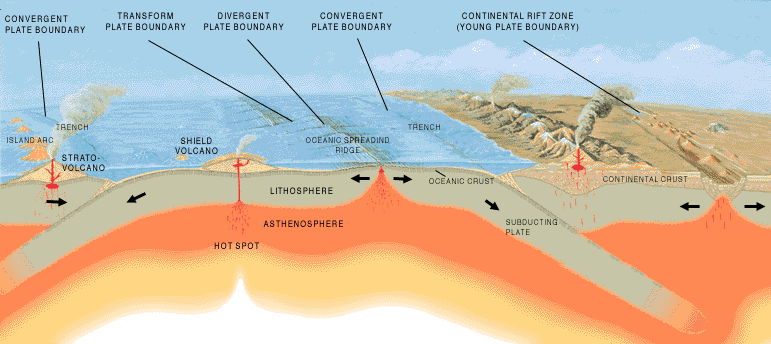
A generalized diagram showing the lithospheric situation associated with the formation of convergent, divergent, and transform plate boundaries. Illustration prepared by the United States Geological Survey.
Plate Boundaries
The edges of Earth's lithospheric plates have boundaries which are both well defined and poorly defined. Well-defined boundaries include mid-ocean ridges and ocean trenches. These boundaries are usually well enough defined that they can be plotted on a map at a reasonably accurate location.
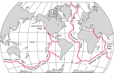
Map showing the geographic location of major mid-ocean ridges. Map by the United States Geological Survey. Click for larger map.
Mid-Ocean Ridges
Mid-ocean ridges are divergent boundaries where convection currents in the mantle lift the ocean floor and produce a rift in the lithosphere that follows the crest of the ridge. New lithosphere is created by volcanic activity along the crest of the ridge, and the plates on either side of the ridge are moving away from one another.
The boundary between the North America Plate and the Eurasian Plate is an example of a divergent boundary at a mid-ocean ridge. All of the plate boundaries that occur down the center of the Atlantic Ocean are divergent boundaries that follow the crest of the Mid-Atlantic Ridge.
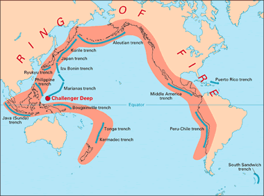
Map showing the geographic location of major ocean trenches in the Pacific Ocean. Map by the United States Geological Survey. Click for larger map.
Ocean Trenches
Ocean trenches form where a plate with a leading edge of oceanic lithosphere collides with another plate. In these situations, an oceanic plate normally subducts into the mantle, forming a topographic low on the ocean floor. The point on the seafloor where the colliding plates are in contact is normally considered to be the geographic location of the plate boundary.
Poorly Defined Boundaries
Some plate boundaries are poorly defined by topographic expression or lithospheric discontinuities. These types of boundaries must be plotted on a map showing their approximate locations. The southern edge of the Caribbean Plate, passing through northern South America, is an example. Another is the boundary between the North American Plate and the Eurasian Plate.
More Plate Tectonics Maps
Here are two plate tectonics maps which show more detail than the maps above.
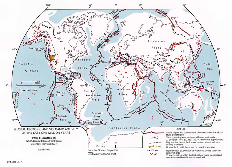
A map of global tectonic and volcanic activity over the last one million years, showing: active ridges, continental extensions, transform faults, ridge spreading rates and directions, continental rifts, subduction and overthrust zones, and generalized volcanic activity. Illustration prepared by Paul D. Lowman Jr., NASA Goddard Space Flight Center. Van der Grinten projection. Click for larger map.
A map of the tectonic plates of the earth showing the different boundary types in different colors. Locations where plates collide (convergent boundaries) are shown in red. Locations where plates are spreading (divergent boundaries) are shown in yellow. And, locations where plates are sliding past one another are shown in orange. This map was prepared by the National Park Service.
| Teaching Plate Tectonics |
Teaching Plate Tectonics | Earth's Internal Structure | Divergent Boundary |
| Convergent Boundary | Transform Boundary | Tectonic Features Map |
| More Plate Tectonics |
 |
Teaching Plate Tectonics |
 |
California Earthquake Maps |
 |
What is the San Andreas Fault? |
 |
The East Africa Rift System |
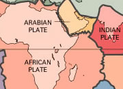 |
Plate Tectonics Map |
 |
What Is The Moho? |
 |
Gifts That Rock |
 |
How did the Hawaiian Islands Form? |

Find Other Topics on Geology.com:

|

| ||

|

| ||

|

| ||

|

|