Home » Teaching Earth Science » Plate Tectonics Lesson Plans
Plate Tectonics Classroom Activities and Lesson Plans
| Teach Plate Tectonics With Drawings |
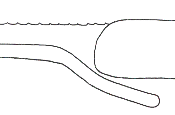
Teaching Plate Tectonics: Use these easy-to-draw illustrations to teach your students about plate tectonics. Step-by-step teaching plan that can be modified for a variety of grade levels.
 |
Teaching Plate Tectonics A good lesson plan that demonstrates plate tectonics through easy-to-draw illustrations. This plate tectonics lesson plan can easily be adapted for elementary, secondary, middle school, and university students. |
 |
Small Grants for Science Teachers A two-page proposal might win $200 to $600 in science supplies for your students. Thousands of teachers win these grants every year. DonorsChoose.org. |
 |
Free Graph Paper and Free Maps Your students can get free printable graph paper, printable maps, printable calendars and more at WaterproofPaper.com, a website affiliated with Geology.com. |
| National Science Teachers Association An organization providing resources, professional development, education conferences, and much more! |
 |
Associations for Science Teachers NSTA's list of science teaching societies in U.S. states and Canadian provinces. Find professional development near you. |
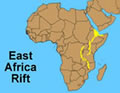 |
East Africa's Great Rift Valley The East African Rift System (EARS) is one the geologic wonders of the world, a place where the earth's tectonic forces are presently trying to create new plates by splitting apart old ones. |
ADVERTISEMENT
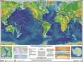 |
This Dynamic Planet The Smithsonian Institute, The United States Geological Survey, and the U.S. Naval Research Laboratory have produced one of the best resources for teaching about earthquakes, volcanoes and plate tectonics. It is a map titled "This Dynamic Planet" - available in .pdf format or as a large-format wall map. It can be used for a wide variety of teaching activities with elementary, secondary, and university students. A teaching companion booklet is also available. |
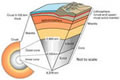 |
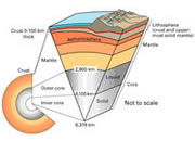
What is the Moho? The Mohorovicic Discontinuity, or "Moho," is the boundary between the crust and the mantle. In geology the word "discontinuity" is used for a surface at which seismic waves change velocity. |
 |
Plate Tectonics This plate tectonics lesson plan has a collection of many activities for the students to perform. This interactive lesson plan can be used for elementary, secondary, middle school, and university level students. |
 |
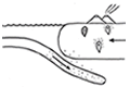
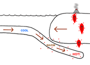
Mystery of the Megaplume This lesson plan requires students to use their basic knowledge of plate tectonics to solve greater mysteries. This classroom activity is appropriate for elementary, secondary, middle school, and university level students with minor modifications. |
 |
Foam Model Plate Tectonics This lesson plan gives students a demonstration to visualize the concept of plate tectonics. This classroom activity can be used to introduce or expand plate tectonics for elementary, secondary, middle school, and university level students. |
|
Small Grants for Science Teachers A two-page proposal might win $200 to $600 in science supplies for your students. Thousands of teachers win these grants every year. DonorsChoose.org. |
|
Free Graph Paper and Free Maps Your students can get free printable graph paper, printable maps, printable calendars and more at WaterproofPaper.com, a website affiliated with Geology.com. |
| National Science Teachers Association An organization providing resources, professional development, education conferences, and much more! |
|
Associations for Science Teachers NSTA's list of science teaching societies in U.S. states and Canadian provinces. Find professional development near you. |
| More Plate Tectonics |
 |
Teaching Plate Tectonics |
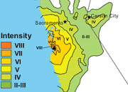 |
California Earthquake Maps |
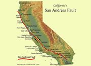 |
What is the San Andreas Fault? |
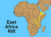 |
The East Africa Rift System |
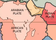 |
Plate Tectonics Map |
 |
What Is The Moho? |
 |
Gifts That Rock |
 |
How did the Hawaiian Islands Form? |

Find Other Topics on Geology.com:

|

| ||

|

| ||

|

| ||

|

|