Home » World Maps » Central America » Guatemala
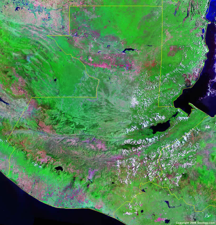
Guatemala Map and Satellite Image
Guatemala Map of Cities, Roads, and Rivers
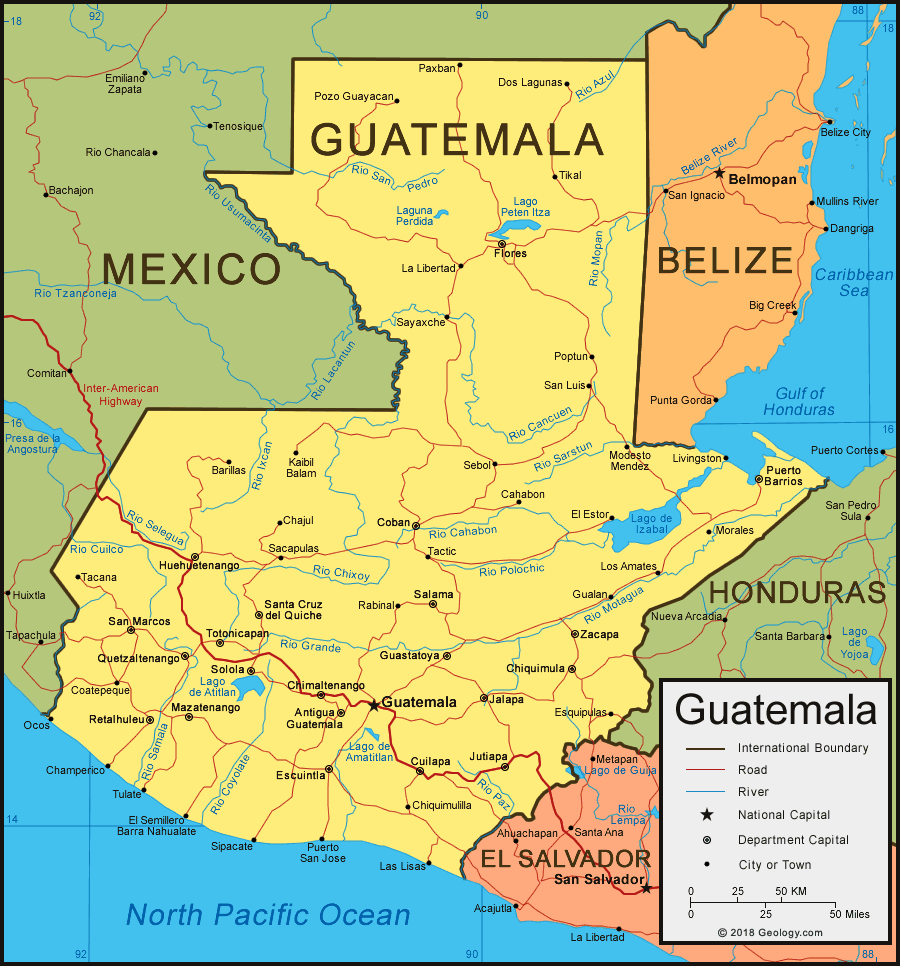
| Guatemala is located in Central America. Guatemala is bordered by the Gulf of Honduras (Caribbean Sea) and the Pacific Ocean, Mexico to the north and west, and Belize, Honduras, and El Salvador to the east. |
ADVERTISEMENT
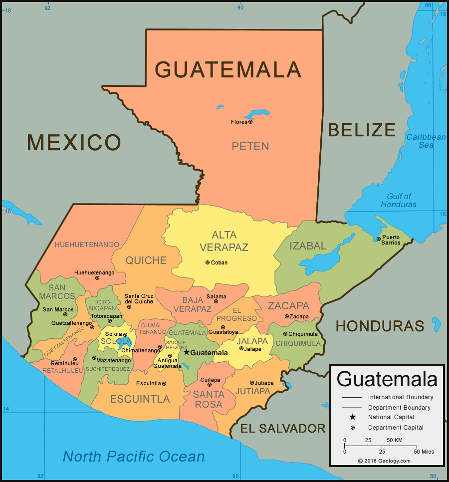
Guatemala Departments Map
Guatemala Bordering Countries:
Belize, El Salvador, Honduras, MexicoRegional Maps:
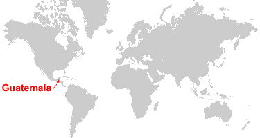
Map of Central America, Map of North America, World MapWhere is Guatemala?
Guatemala Satellite Image
ADVERTISEMENT

Explore Guatemala Using Google Earth:
Google Earth is a free program from Google that allows you to explore satellite images showing the cities and landscapes of Guatemala and all of Central America in fantastic detail. It works on your desktop computer, tablet, or mobile phone. The images in many areas are detailed enough that you can see houses, vehicles and even people on a city street. Google Earth is free and easy-to-use.
Guatemala on a World Wall Map:
Guatemala is one of nearly 200 countries illustrated on our Blue Ocean Laminated Map of the World. This map shows a combination of political and physical features. It includes country boundaries, major cities, major mountains in shaded relief, ocean depth in blue color gradient, along with many other features. This is a great map for students, schools, offices and anywhere that a nice map of the world is needed for education, display or decor.
Guatemala On a Large Wall Map of North America:
If you are interested in Guatemala and the geography of Central America, our large laminated map of North America might be just what you need. It is a large political map of North America that also shows many of the continent's physical features in color or shaded relief. Major lakes, rivers, cities, roads, country boundaries, coastlines and surrounding islands are all shown on the map.Guatemala Cities:
Amatitlan, Antigua Guatemala, Barillas, Cahabon, Chajul, Champerico, Chimaltenango, Chiquimula, Chiquimulilla, Coatepeque, Coban, Concepcion las Minas, Cuilapa, Dos Lagunas, El Estor, El Progreso, El Semillero Barra Nahualate, Escuintla, Esquipulas, Flores, Francisco Vela, Gualan, Guastatoya, Guatemala, Huehuetenango, Jalapa, Jutiapa, Kaibil Balam, La Libertad, Las Lisas, Livingston, Los Amates, Los Delores, Mariscos, Mazatenango, Mixco, Modesto Mendez, Morales, Ocos, Paxban, Poptun, Pozo Guayacan, Pueblo Nuevo Tiquisate, Puerto Barrios, Puerto San Jose, Quetzaltenango, Rabinal, Retalhuleu, Rubelsanto, Sacapulas, Salama, San Andres, San Jose, San Luis, San Marcos, Santa Cruz del Quiche, Santo Tomas de Castilla, Sayaxche, Sebol, Sipacate, Siquinala, Solola, Tacana, Tactic, Tikal, Totonicapan, Tulate, Villa Nueva, and Zacapa.Guatemala Departments:
Alta Verapaz, Baja Verapaz, Chimaltenango, Chiquimula, El Progreso, Escuintla, Guatemala, Huehuetenango, Izabal, Jalapa, Jutiapa, Peten, Quetzaltenango, Quiche, Retalhuleu, Sacatepequez, San Marcos, Santa Rosa, Solola, Suchitepequez, Totonicapan, and Zacapa.Guatemala Locations:
Azul River, Bahia de Amatique, Cahabon River, Cancuen River, Chixoy River, Coyolate River, Cuilco River, Gulf of Honduras (Caribbean Sea), Ixcan River, Lago de Amatitlan, Lago de Atitlan, Lago de Guija, Lago de Izabal, Lago Peten Itza, Laguna del Tigre, Laguna Perdida, Mopan River, Motagua River, Pacific Ocean, Paz River, Polochic River, Rio Grande River, Salinas River, Samala River, San Miguel River, San Pedro River, Sarstun River, Selegua River, Sierra de las Minas, Sierra de los Cuchumatanes, Sierra Madre and Xalbal River.Guatemala Natural Resources:
Guatemala has a variety of natural resources, which include rare woods, chicle, fish, and nickel. Sources of fuel include petroleum and hydropower.Guatemala Natural Hazards:
There are numerous volcanoes in the mountains of Guatemala, and these are the source for the country's occasional violent earthquake. Another natural hazard is that the country's Caribbean coast is extremely susceptible to hurricanes and other tropical storms.Guatemala Environmental Issues:
Environmental issues for Guatemala include water pollution and soil erosion. In addition there is deforestation in the country's Peten rainforest.
ADVERTISEMENT