Home » World Maps » Asia » Malaysia
Malaysia Map and Satellite Image
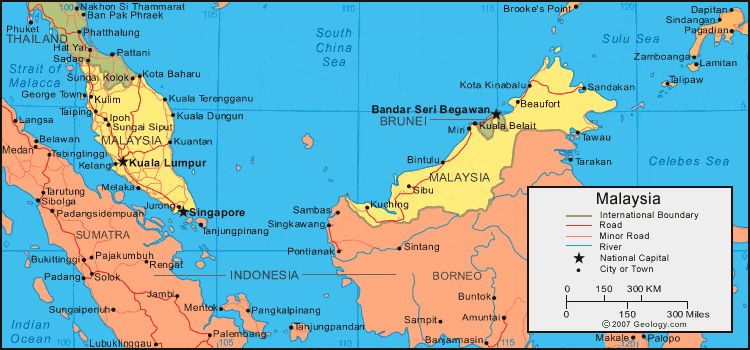
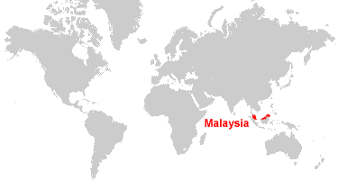
| Malaysia is located in southeastern Asia. The country has two regions: Peninsular Malaysia and East Malaysia. They are separated by the South China Sea. On the island of Borneo, East Malaysia is bordered by Brunei to the north and Indonesia to the south. Peninsular Malaysia is bordered by Thailand to the north, and Singapore lies just south of the Johor Strait. |
ADVERTISEMENT
Malaysia Neighboring Countries:
Brunei, Indonesia, Singapore, ThailandRegional Maps:
Map of Borneo, Map of Asia, World MapWhere is Malaysia?
Malaysia Satellite Image

ADVERTISEMENT

Explore Malaysia Using Google Earth:
Google Earth is a free program from Google that allows you to explore satellite images showing the cities and landscapes of Malaysia and all of Asia in fantastic detail. It works on your desktop computer, tablet, or mobile phone. The images in many areas are detailed enough that you can see houses, vehicles and even people on a city street. Google Earth is free and easy-to-use.
Malaysia on a World Wall Map:
Malaysia is one of nearly 200 countries illustrated on our Blue Ocean Laminated Map of the World. This map shows a combination of political and physical features. It includes country boundaries, major cities, major mountains in shaded relief, ocean depth in blue color gradient, along with many other features. This is a great map for students, schools, offices and anywhere that a nice map of the world is needed for education, display or decor.
Malaysia On a Large Wall Map of Asia:
If you are interested in Malaysia and the geography of Asia our large laminated map of Asia might be just what you need. It is a large political map of Asia that also shows many of the continent's physical features in color or shaded relief. Major lakes, rivers, cities, roads, country boundaries, coastlines and surrounding islands are all shown on the map.Malaysia Cities:
Alor Setar, Batu Pahat, Beaufort, Binfulu, Chukai, George Town, Ipoh, Johor Bahru, Jurong, Kelang, Kota Baharu, Kota Kinabalu, Kuala Dungun, Kuala Lumpur, Kuala Terengganu, Kuantan, Kuching, Kudat, Kulim, Melaka, Miri, Muar, Sandakan, Seremban, Sibu, Sungai Kolok, Sungai Petani, Sungai Siput, Taiping and Tawau.Malaysia Locations:
Balabac Strait, Brunei Bay, Celebes Sea, Cowie Harbour, Darvel Bay, Gulf of Thailnad, Igan River, Labule Bay, Lupar River, Marudu Bay, Rajang River, Sibutu Passage, Singapore Strait, South China Sea, Strait of Malacca, Sulu Sea and Tasek Dampar.Malaysia Natural Resources:
Malaysia has exploitable resources which include the fossil fuels petroleum and natural gas. Some of the metallic resources for this country are tin, copper, iron ore and bauxite. Timber is also a natural resource.Malaysia Natural Hazards:
Natural hazards for the country of Malaysia include forest fires, flooding, and landslides.Malaysia Environmental Issues:
Some of Malaysia's environmental issues are water pollution from raw sewage. The country's issues regarding the air include the smoke and haze from Indonesian forest fires, and air pollution from industrial and vehicular emissions. There is also deforestation.
ADVERTISEMENT