Home » World Maps » South America
South America Map and Satellite Image - Click a Country

| South America is a continent south of North America, between the Atlantic Ocean and the Pacific Ocean. |
ADVERTISEMENT
Countries in South America:
Argentina, Bolivia, Brazil, Chile, Colombia, Ecuador, French Guiana, Guyana, Paraguay, Peru, Suriname, Uruguay, Venezuela.
Where is South America?


Political Map of South America:
This is a political map of South America which shows the countries of South America along with capital cities, major cities, islands, oceans, seas, and gulfs. The map is a portion of a larger world map created by the Central Intelligence Agency using Robinson Projection. You can also view the full pan-and-zoom CIA World Map as a PDF document.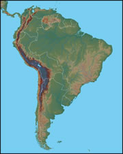
Physical Map of South America:
This map shows the continent of South America in shaded relief. The Andes Mountains are easy to spot in dark brown. This mountain range, which runs through Venezuela, Colombia, Ecuador, Peru, Bolivia, Chile, and Argentina, was formed by the collision of the South American Plate and the Nazca Plate. The Amazon Basin makes up much of Brazil; this drainage system goes all the way up to the eastern foothills of the Andes.
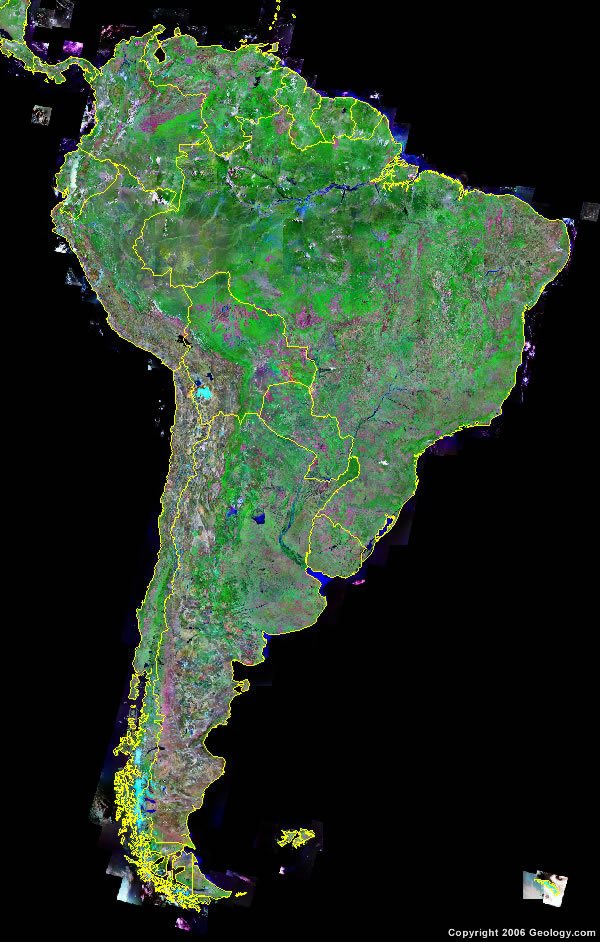
Explore South America Using Google Earth:
Google Earth is a free program from Google that allows you to explore satellite images showing the cities and landscapes of South America and the rest of the world in fantastic detail. It works on your desktop computer, tablet, or mobile phone. The images in many areas are detailed enough that you can see houses, vehicles and even people on a city street. Google Earth is free and easy-to-use.
South America on a World Wall Map:
South America is one of 7 continents illustrated on our Blue Ocean Laminated Map of the World. This map shows a combination of political and physical features. It includes country boundaries, major cities, major mountains in shaded relief, ocean depth in blue color gradient, along with many other features. This is a great map for students, schools, offices and anywhere that a nice map of the world is needed for education, display or decor.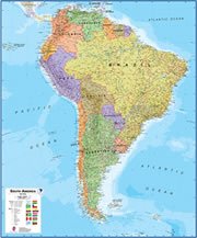
Large Wall Map of South America:
If you are interested in the geography of South America, our large laminated map of South America might be just what you need. It is a large political map of South America that also shows many of the continent's physical features in color or shaded relief. Major lakes, rivers, cities, roads, country boundaries, coastlines and surrounding islands are all shown on the map.South America Satellite Image
South America Cities:
Cartagena, Maracaibo, Caracas, Maturin, Merida, Cucuta, Georgetown, Paramaribo, Medellin, Manizales, Bogota, Cayenne, Ibague, Cali, Quito, Belem, Guayaquil, Manaus, Sao Luis, Cuenca, Fortaleza, Teresina, Recife, Lima, Salvador, Cuiaba, Brasilia, La Paz, Goiania, Cochabamba, Santa Cruz, Sucre, Belo Horizonte, Londrina, Rio De Janeiro, Sao Paulo, Salta, Asuncion, Curitiba, San Miguel de Tucuman, Porto Alegre, Cordoba, Santa Fe, Rosario, Valparaiso, Santiago, Buenos Aires, Montevideo, Concepcion, Mar del Plata.South America Locations:
Amazonas (Amazon River) in Brazil, Atlantic Ocean, Cordillera de los Andes along the east coast, Lago Maracaibo in Venezuela, Lago Titicaca between Peru and Bolivia, Laguna Mar Chiquita in Argentina, Pacific Ocean, Parana River in Brazil, Rio de la Plata between Uruguay and Argentina and Salar de Uyuni in Brazil.South America Natural Resources:
South America has a wide range of natural resources. Please consult the natural resources list for specific countries.South America Natural Hazards:
South America has a wide range of natural hazards. Please consult the hazards list for specific countries.South America Environmental Issues:
South America has a wide range of environmental issues. Please consult the environmental issues list for specific countries.
ADVERTISEMENT