Home » World Maps » South America » Argentina
Argentina Map and Satellite Image


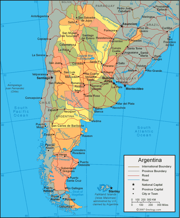
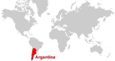
| Argentina is located in South America. Argentina is bordered by Chile to the west, Bolivia and Paraguay to the north, and Uruguay, Brazil, and the Atlantic Ocean to the east. |
ADVERTISEMENT
Argentina Bordering Countries:
Bolivia, Brazil, Chile, Paraguay, UruguayRegional Maps:
Falkland Islands, South America, Antarctica, World MapWhere is Argentina?

Explore Argentina Using Google Earth:
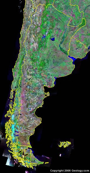
Google Earth is a free program from Google that allows you to explore satellite images showing the cities and landscapes of Argentina and all of South America in fantastic detail. It works on your desktop computer, tablet, or mobile phone. The images in many areas are detailed enough that you can see houses, vehicles and even people on a city street. Google Earth is free and easy-to-use.Argentina on a World Wall Map:
Argentina is one of nearly 200 countries illustrated on our Blue Ocean Laminated Map of the World. This map shows a combination of political and physical features. It includes country boundaries, major cities, major mountains in shaded relief, ocean depth in blue color gradient, along with many other features. This is a great map for students, schools, offices and anywhere that a nice map of the world is needed for education, display or decor.Argentina On a Large Wall Map of South America:
If you are interested in Argentina and the geography of South America our large laminated map of South America might be just what you need. It is a large political map of South America that also shows many of the continent's physical features in color or shaded relief. Major lakes, rivers, cities, roads, country boundaries, coastlines and surrounding islands are all shown on the map.ADVERTISEMENT
Argentina Cities:
Avellaneda, Bahia Blanca, Buenos Aires, Catamarca, Cipolletti, Comodoro Rivadavia, Concordia, Cordoba, Corrientes, Curuzu Cuatia, Formosa, General Villegas, Gobernador Gregores, La Plata, La Ribja, Lanus, Las Heras, Mar del Plata, Mercedes, Moron, Necochea, Neuquen, Parana, Posadas, Puerot Santa Cruz, Puerto Deseado, Punta Alta, Rawson, Realico, Renanco, Resario, Resistencia, Rio Cuarto, Rio Gallegos, Salta, San Carlos de Bariloche, San Justo, San Luis, San Nicolas, San Rafael, San Salvador de Jujuy, Santa Fe, Santa Rosa, Santiago del Estero, Telen, Trelew, Ushuaia, Venado Tuerto, Viedma, Villa Nueva and Zapala.Argentina Locations:
Atlantic Ocean, Bahia Blanca, Bahia Flasa, Bahia Grande, Bahia Union, Cordillera de los Andes, Golfo Nuevo, Golfo San Jorge, Golfo San Matias, Gran Laguna Salada, Lago Argentino, Lago Buenos Aires, Lago Cardiel, Lago Pueyrredon, Lago Viedma, Laguna Ibera, Laguna mar Chiquita, Pacific Ocean, Rio Chico, Rio Chubut, Rio Colorado, Rio Deseado, Rio Parana, Rio Pilcomayo, Rio Salado and Uruguay River.Argentina Natural Resources:
Metallic resources of Argentina include lead, zinc, tin, copper, iron ore and manganese. Fuel resources include petroleum and uranium.Argentina Natural Hazards:
Argentina does have heavy flooding, and the pampas and northeast are hit by violent windstorms, called pamperos. San Miguel de Tucuman and Mendoza (areas in the Andes) are subject to earthquakes.Argentina Environmental Issues:
Argentina is a world leader in setting voluntary greenhouse gas targets. However, they still have a number of environmental problems typical of their industrializing economy. These include: air pollution; water pollution; soil degradation; deforestation; desertification.ADVERTISEMENT


