Home » Records » Tallest Tsunami
World's Tallest Tsunami
A tsunami with a record run-up height of 1720 feet occurred in Lituya Bay, Alaska

Lituya Bay: The photo above shows Lituya Bay, from an aircraft over the Gulf of Alaska. The landslide that triggered the tsunami originated from the top of the steep cliffs along the far left side of the bay. About 40 million cubic feet of rock fell into Gilbert Inlet (not visible in this view). The rock displaced much of the water in Gilbert Inlet to form a wave that overran the slope on the opposite side of the inlet. As the wave progressed through Lituya Bay, it uprooted millions of trees along both shorelines. These deforested areas can be seen in this photo by D.J. Miller, U.S. Geological Survey.
On the night of July 9, 1958, an earthquake along the Fairweather Fault in the Alaska Panhandle loosened about 40 million cubic yards (30.6 million cubic meters) of rock high above the northeastern shore of Lituya Bay. This mass of rock plunged from an altitude of approximately 3000 feet (914 meters) down into the waters of Gilbert Inlet (see map below). The impact force of the rockfall generated a local tsunami that crashed against the southwest shoreline of Gilbert Inlet.
The wave hit with such power that it swept completely over the spur of land that separates Gilbert Inlet from the main body of Lituya Bay. The wave then continued down the entire length of Lituya Bay, over La Chaussee Spit and into the Gulf of Alaska. The force of the wave removed all trees and vegetation from elevations as high as 1720 feet (524 meters) above sea level. Millions of trees were uprooted and swept away by the wave. This is the highest runup ever recorded for a tsunami.
Lituya Bay Map
BBC Video
What Caused the Lituya Bay Tsunami?
Survivor Accounts
Image Collection
Conclusions
Was It a Real Tsunami??
Detail Map: Lituya Bay, Alaska
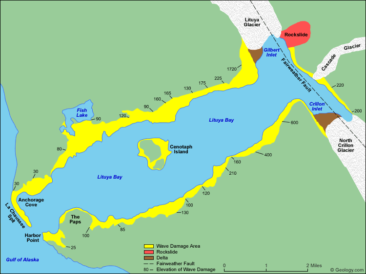
Lituya Bay is an ice-scoured tidal inlet on the northeast shore of the Gulf
of Alaska. It is about seven miles long (11.3 kilometers) and up to two miles wide (3.2 kilometers). It has a maximum
depth of about 720 feet (219 meters), but a sill of only 32 feet (9.7 meters) in depth separates it from the Gulf of Alaska between La Chaussee Spit and Harbor Point.
The Fairweather Fault trends across the northeast end of the Bay and is responsible for
the T-shape of the bay. Glacial scour has exploited the weak zone along the fault to produce a long linear trough known as the Fairweather Trench. The Lituya Glacier and North Crillon Glacier have scoured portions of the Fairweather Trench in the area of Lituya Bay. Gilbert Inlet and Crillon Inlet occupy the Fairweather Trench on the northeast end of Lituya Bay.
The rockfall of July 9, 1958 occurred on steep cliffs above the northeast shore of Gilbert
Inlet. It is marked on the map above in red. The rocks fell from an elevation of about 3000 feet (914 meters). The impact of 40 million cubic yards (30.6 million cubic meters) of rock hitting the water produced a local tsunami that swept the entire length of the Lituya Bay and over the La Chaussee Spit. This wave stripped all vegetation and soil from along the edges of the bay. This damaged area is shown in yellow on the map above. The numbers are elevations (in feet) of the upper edge of the wave damage area and represent the approximate elevation of the wave as it traveled through the bay. Map redrawn from data included in United States Geological Survey Professional Paper 354-C.
What Caused the Lituya Bay Tsunami?
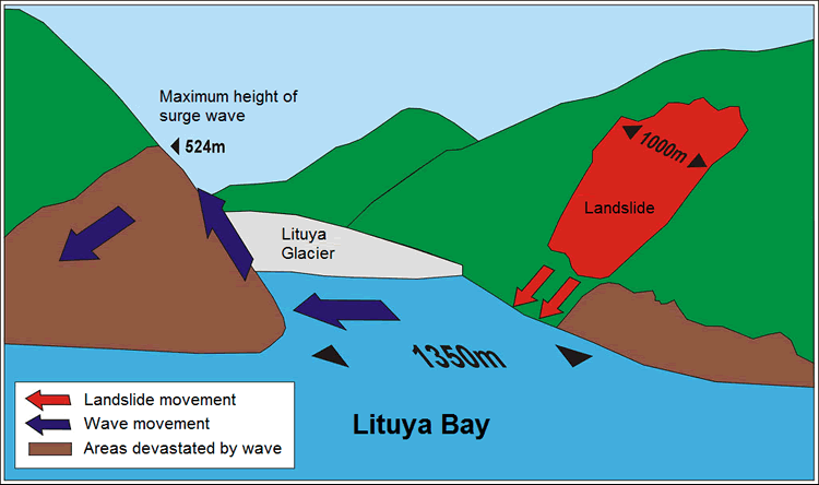
Cause of the Lituya Bay Tsunami: The cartoon above illustrates the events that caused the Lituya Bay tsunami.
1) An earthquake on the Fairweather Fault caused about 40 million cubic yards of rock to fall from the east wall of Gilbert Inlet.
2) When 40 million cubic yards of rock fell into Gilbert Inlet, the velocity of the rock and its mass produced a powerful wave that rushed across the inlet.
3) That wave ran up the west wall of Gilbert Inlet to an elevation of about 1720 feet (the water of Gilbert Inlet has an elevation of sea level).
4) The wave overtopped the west wall of Gilbert Inlet, descended into Lituya Bay, and rushed through the bay to the Gulf of Alaska, uprooting millions of trees along both shorelines of Lituya Bay.
The image above is in the public domain and was created by a Wikipedian named SirGorg.
.png)
Eyewitness Accounts from Survivors(As reported by Don J. Miller in United States Geological Survey Professional Paper 354-C, Giant Waves in Lituya Bay, Alaska, 1960)Account of Howard G. UlrichMr. Ulrich and his 7-year-old son, on the Edrie, entered Lituya Bay about 8:00 p.m. and anchored in about 5 fathoms of water in a small cove on the south shore. Ulrich was awakened by the violent rocking of the boat, noted the time, and went on deck to watch the effects of the earthquake - described as violent shaking and heaving, followed by avalanching in the mountains at the head of the bay. An estimated 2 1/2 minutes after the earthquake was first felt a deafening crash was heard at the head of the bay. According to Ulrich, "The wave definitely started in Gilbert Inlet, just before the end of the quake. It was not a wave at first. It was like an explosion, or a glacier sluff. The wave came out of the lower part, and looked like the smallest part of the whole thing. The wave did not go up 1,800 feet, the water splashed there."Ulrich continued to watch the progress of the wave until it reached his boat about 2 1/2 to 3 minutes after it was first sighted. Being unable to get the anchor loose, he let out all of the chain (about 40 fathoms) and started the engine. Midway between the head of the bay and Cenotaph Island the wave appeared to be a straight wall of water possibly 100 feet high, extending from shore to shore. The wave was breaking as it came around the north side of the island, but on the south side it had a smooth, even crest. As it approached the Edrie the wave front appeared very steep, and 50 to 75 feet high. No lowering or other disturbance of the water around the boat, other than vibration due to the earthquake, was noticed before the wave arrived. The anchor chain snapped as the boat rose with the wave. The boat was carried toward and probably over the south shore, and then, in the backwash, toward the center of the bay. The wave crest seemed to be only 25 to 50 feet wide, and the back slope less steep than the front. After the giant wave passed the water surface returned to about normal level, but was very turbulent, with much sloshing back and forth from shore to shore and with steep, sharp waves up to 20 feet high. These waves, however, did not show any definite movement either toward the head or the mouth of the bay. After 25 to 30 minutes the bay became calm, although floating logs covered the water near the shores and were moving out toward the center and the entrance. After the first giant wave passed Ulrich managed to keep the boat under control, and went out the entrance at 11:00 p.m. on what seemed to be a normal ebb flow. Account of William A. SwansonMr. and Mrs. Swanson on the Badger entered Lituya Bay about 9:00 p.m., first going in as far as Cenotaph Island and then returning to Anchorage Cove on the north shore near the entrance, to anchor in about 4 fathoms of water. Mr. Swanson was wakened by violent vibration of the boat, and noted the time on the clock in the pilot house. A little more than a minute after the shaking was first felt, but probably before the end of the earthquake, Swanson looked toward the head of the bay, past the north end of Cenotaph Island and saw what he thought to be the Lituya Glacier, which had "risen in the air and moved forward so it was in sight. * * * It seemed to be solid, but was jumping and shaking * * * Big cakes of ice were falling off the face of it and down into the water." After a little while "the glacier dropped back out of sight and there was a big wall of water going over the point" (the spur southwest of Gilbert Inlet). Swanson next noticed the wave climb up on the south shore near Mudslide Creek. As the wave passed Cenotaph Island it seemed to be about 50 feet high near the center of the bay and to slope up toward the sides. It passed the island about 2 1/2 minutes after it was first sighted, and reached the Badger about 1 1/2 minutes later. No lowering or other disturbance of the water around the boat was noticed before the wave arrived. The Badger, still at anchor, was lifted up by the wave and carried across La Chaussee Spit, riding stern first just below the crest of the wave, like a surfboard. Swanson looked down on the trees growing on the spit, and believes that he was about 2 boat lengths (more than 80 feet) above their tops. The wave crest broke just outside the spit and the boat hit bottom and foundered some distance from the shore. Looking back 3 to 4 minutes after the boat hit bottom Swanson saw water pouring over the spit, carrying logs and other debris. He does not know whether this was a continuation of the wave that carried the boat over the spit or a second wave. Mr. and Mrs. Swanson abandoned their boat in a small skiff, and were picked up by another fishing boat about 2 hours later. |
Landsat Image: Lituya Bay, Alaska
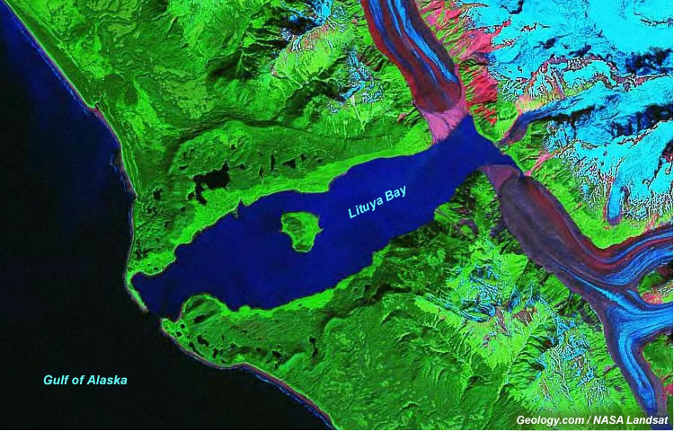
This is a Landsat Geocover image of Lituya Bay produced with Landsat data collected by NASA about forty years after the tsunami. Areas where soil and vegetation were removed are still clearly visible. The wave-damaged areas are the light green areas of different vegetation color around the rim of the bay.
Oblique Aerial Photo: Lituya Bay, Alaska
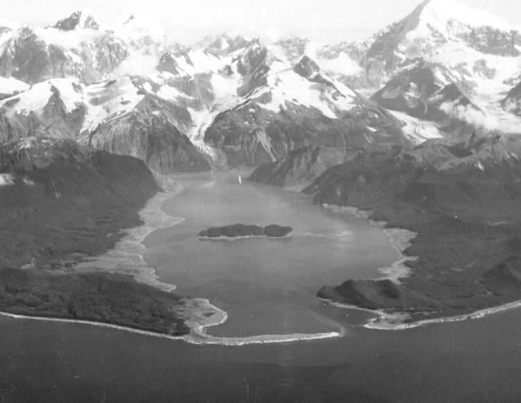
Lituya Bay a few weeks after the 1958 tsunami. The areas of destroyed forest along the shorelines are clearly recognizable as the light areas rimming the bay. A fishing boat anchored in the cove at lower left was carried over the spit in the foreground; a boat under way near the entrance was sunk; and a third boat, anchored near the lower right, rode out the wave. Photo by D.J. Miller, United States Geological Survey.
Isoseismal Map: Magnitude 7.7 Alaska Earthquake of July 9, 1958
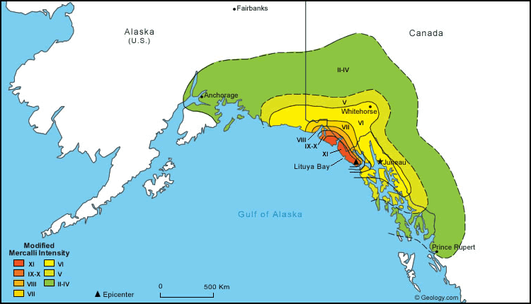
This is an isoseismal map showing the impact of the Magnitude 7.7 Alaska Earthquake of July 9, 1958 in Modified Mercalli Scale units. Lituya Bay was in the area of XI intensity. The isoseismal contours near the epicenter parallel the Fairweather Fault. Map information from Seismicity of the United States, 1568-1989 (Revised), by Carl W. Stover and Jerry L. Coffman, U.S. Geological Survey Professional Paper 1527, United States Government Printing Office, Washington: 1993.
Source of the Rockfall: The Cliff Overlooking Gilbert Inlet
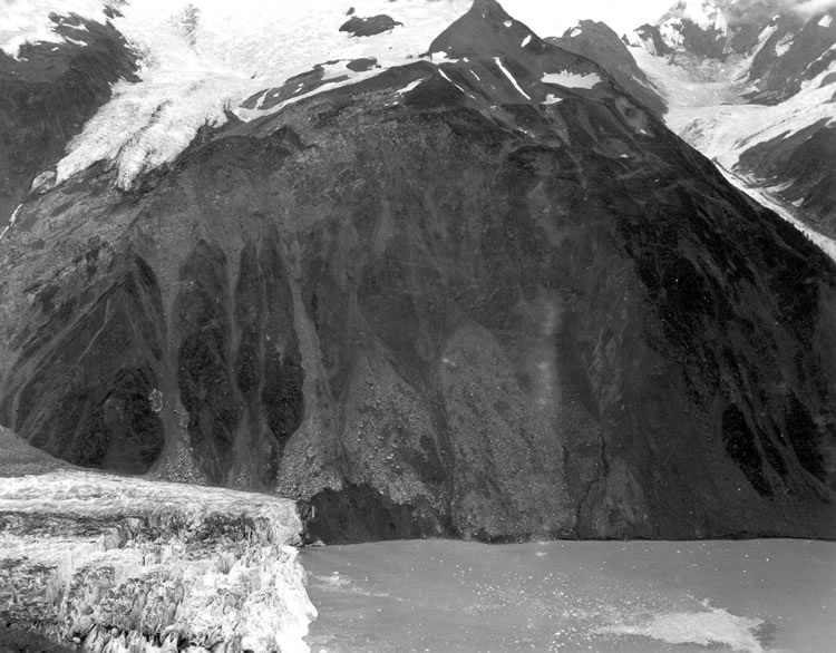
The cliff on the northeast wall of Gilbert Inlet showing the scar of the 40 million cubic yard (30.6 million cubic meters) rockslide that occurred on the day before this photo. The head of the slide was at an altitude of about 3,000 feet (914 meters), just below snowfield in upper center. The elevation of water in Lituya Bay is sea level. The front of Lituya Glacier is visible in the lower left corner. Photo by D.J. Miller, United States Geological Survey.
Looking down the Fairweather Fault Trench
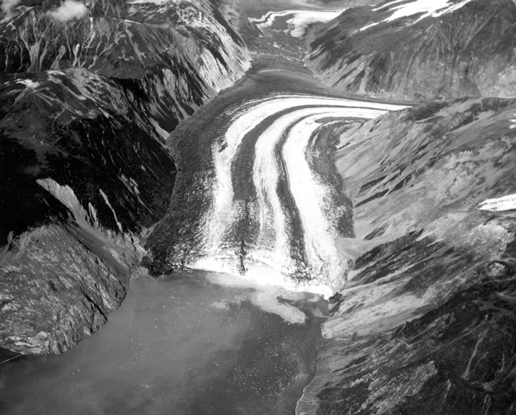
Photo looking down the Fairweather Fault Trench at the head of Lituya Bay. The front of Lituya Glacier with lateral and medial moraines is seen terminating in Gilbert Inlet. The cliff where the rockslide originated is on the right side of Gilbert Inlet. The opposite valley wall on the left side of Gilbert Inlet received the full force of the big wave, stripping it of soil and trees. Photo by D.J. Miller, United States Geological Survey.
Spur of land between Gilbert Inlet and Lituya Bay
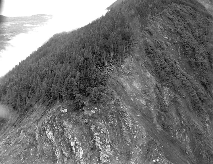
The spur of land between Gilbert Inlet and Lituya Bay that received the full force of the wave. Trees and soil were stripped away to an elevation of 1720 feet (524 meters) above the surface of Lituya Bay. Photo by D.J. Miller, United States Geological Survey.
Gilbert Inlet, the Rockfall Slope, and Wave Damage
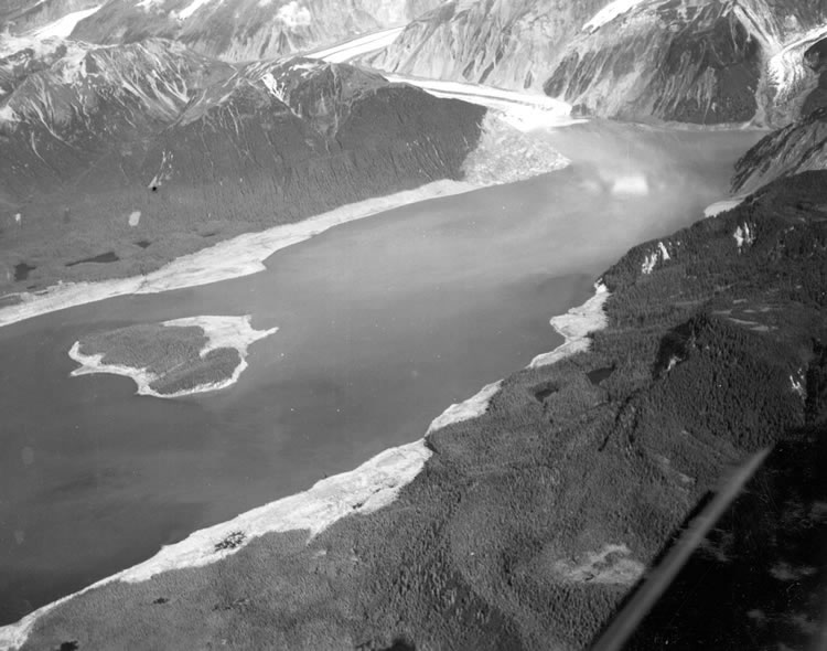
An aerial photo looking at the head of Lituya Bay. The rockfall slope is at the top right corner of the photo. Gilbert Inlet and the terminus of the Lituya Glacier are immediately to the left of the rockfall slope. Deforested shorelines can be seen on both sides of Lituya Bay. View is from the south. Photo by D.J. Miller, United States Geological Survey.
Spruce Tree Snapped Off by the Wave - Seven Miles from its Source
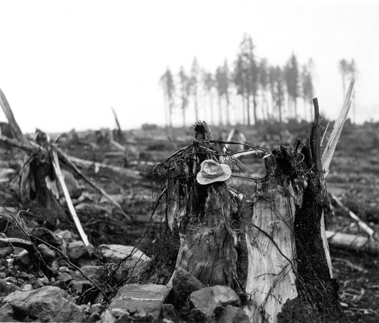
Stump of living spruce tree broken off by the giant wave at Harbor Point, mouth of Lituya Bay. Brim of hat is 12 inches in diameter. This tree is located about seven miles (11.3 kilometers) from where the wave originated. Photo by D.J. Miller, United States Geological Survey.
Wave Damage at the Mouth of Lituya Bay
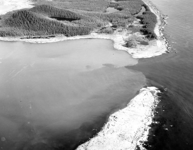
Wave damage on the south shore of Lituya Bay, from Harbor Point to La Chaussee Spit, southwest of Crillon Inlet. Tree trunks can be seen in the water and tree stumps along the lower shoreline. This location is seven miles (11.3 kilometers) away from where the wave originated. Photo by D.J. Miller, United States Geological Survey.
Conclusions
A third boat was in Lituya Bay at the time of the tsunami. It was anchored near the mouth of the bay and was sunk by the big wave. There are no known survivors from this boat, and it was believed that there were two people on board.
Prior to the July, 1958 tsunami, Don J. Miller of the United States Geological Survey had been studying evidence for the occurrence of large waves in Lituya Bay. He had documented evidence for at least four previous large waves with estimated dates of 1936, 1899, 1874, and 1853 (or 1854). All of these waves were significant in size, but shoreline evidence for all of them was removed by the 1958 wave. Mr. Miller was in Alaska when the July 1958 wave occurred and flew to Lituya Bay the following day. He took the photographs shown above in July and August and documented the older waves in United States Geological Survey Professional Paper 354-C, Giant Waves in Lituya Bay, Alaska, 1960.
With such a history of large waves, Lituya Bay should be considered as a dangerous body of water prone to a few large waves every century. When will the next one occur?
Was This Wave Really a Tsunami?
Shortly after we published this page we received several email messages informing us that the Lituya Bay wave was NOT a tsunami.
Before publishing this page, we confirmed that USGS has used the name "tsunami" for this wave in numerous publications and open file reports. As recently as July 9, 2021, USGS released another report and they are still calling it a tsunami. Please see below...
Preliminary Assessment of the Wave Generating Potential from Landslides at Barry Arm, Prince William Sound, Alaska: by Katherine R. Barnhart, Ryan P. Jones, David L. George, Jeffrey A. Coe, and Dennis M. Staley; published as Open-File Report 2021-1071, 28 pages, by the United States Geological Survey, 2021.
Quote from the publication: "Examples of large tsunamigenic landslides in recently deglaciated terrain include July 9, 1958, Lituya Bay, Alaska (Miller, 1960a, b; Ward and Day, 2010); April 27, 1975, Kitimat, British Columbia (Kirby and others, 2016); October 17, 2015, Taan Fjord, Alaska (George and others, 2017; Haeussler and others, 2018; Higman and others, 2018); and June 17, 2017, Karrat Fjord, Greenland (Bessette-Kirton and others, 2017; Poli, 2017; Gauthier and others, 2018)."
| More Earth Extremes |
 |
The World*s Largest Highly Acidic Lake |
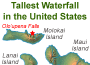 |
The Tallest Waterfall in the U.S. |
 |
The Most Explosive Eruption |
 |
Largest Volcano - |
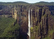 |
Angel Falls |
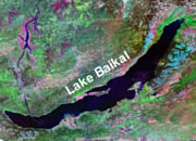 |
Deepest Lake in the World |
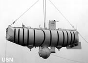 |
Bathyscaphe Trieste |
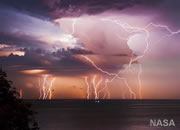 |
World Record Lightning |

Find Other Topics on Geology.com:

|

| ||

|

| ||

|

| ||

|

|