Home » Plate Tectonics » Plate Tectonics and the Hawaiian Hot Spot
Plate Tectonics and the Hawaiian Hot Spot
Republished from Eruptions of Hawaiian Volcanoes - Past, Present, and Future
by Robert Tilling, Christina Heliker, and Donald Swanson
U.S. Geological Survey General Information Product 117.
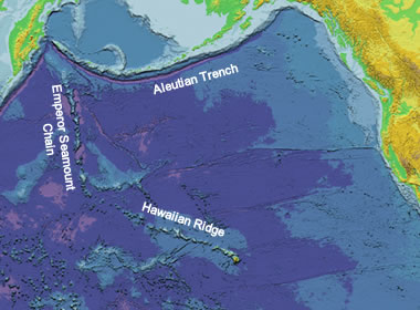
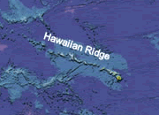
Pacific Basin Map: Map of the Pacific Basin showing the location of the Hawaiian Ridge-Emperor Seamount Chain and the Aleutian Trench. Base map from "This Dynamic Planet."
Origin of the Hawaiian Islands
The Hawaiian Islands are the tops of gigantic volcanic mountains formed by countless eruptions of fluid lava over several million years; some tower more than 30,000 feet above the seafloor. These volcanic peaks rising above the ocean surface represent only the tiny, visible part of an immense submarine ridge, the Hawaiian Ridge—Emperor Seamount Chain, composed of more than 80 large volcanoes.
| Mauna Kea Volcano on the island of Hawaii has an altitude of 13,796 feet. However, the base of the island begins about 18,000 feet below sea level. If the island of Hawaii was considered to be a "mountain" it would be the world's tallest, beating Mount Everest by over 1000 feet. Learn more. |
This range stretches across the Pacific Ocean floor from the Hawaiian Islands to the Aleutian Trench. The length of the Hawaiian Ridge segment alone, between the Island of Hawai'i and Midway Island to the northwest, is about 1,600 miles, roughly the distance from Washington, D.C., to Denver, Colorado. The amount of lava erupted to form this huge ridge, about 186,000 cubic miles, is more than enough to cover the State of California with a layer 1 mile thick.
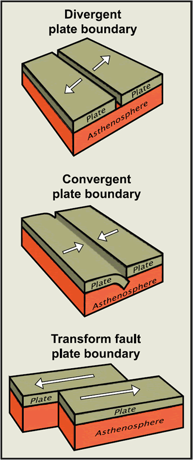
Types of plate boundaries: Block diagrams of divergent, convergent and transform plate boundaries.
Plate Tectonics and the Hawaiian Hot Spot
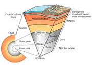
In the early 1960s, the related concepts of "seafloor spreading" and "plate tectonics" emerged as powerful new hypotheses that geologists used to interpret the features and movements of the Earth's surface layer. According to the plate tectonic theory, the Earth's rigid outer layer, or "lithosphere," consists of about a dozen slabs or plates, each averaging 50 to 100 miles thick. These plates move relative to one another at average speeds of a few inches per year-about as fast as human fingernails grow. Scientists recognize three common types of boundaries between these moving plates (see diagrams):
(1) Divergent Boundaries
Adjacent plates pull apart, such as at the Mid-Atlantic Ridge, which separates the North and South America Pates from the Eurasia and Africa Plates. This pulling apart causes "seafloor spreading" as new material from the underlying less rigid layer, or "asthenosphere," fills the cracks and adds to these oceanic plates. See: Teaching About Divergent Plate Boundaries.
(2) Convergent Boundaries
Two plates move towards one another and one is dragged down (or "subducted") beneath the other. Convergent plate boundaries are also called "subduction zones" and are typified by the Aleutian Trench, where the Pacific Plate is being subducted under the North America Plate. Mount St. Helens (southwest Washington) and Mount Fuji (Japan) are excellent examples of subduction-zone volcanoes formed along convergent plate boundaries. See: Teaching About Convergent Plate Boundaries.
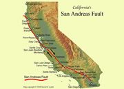
(3) Transform Boundaries
One plate slides horizontally past another. The best-known example is the earthquake-prone San Andreas Fault Zone of California, which marks the boundary between the Pacific and North America Plates. See: Teaching About Transform Plate Boundaries.
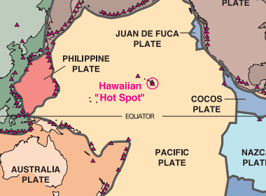
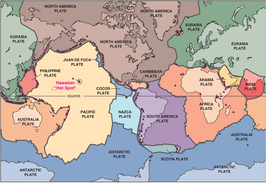
Tectonic Plates and Active Volcanoes of the World: Most active volcanoes are located along or near the boundaries of Earth's shifting tectonic plates. Hawaiian volcanoes, however, occur in the middle of the Pacific Plate and are formed by volcanism over the Hawaiian "Hot Spot" (see text). Only some of the Earth's more than 500 active volcanoes are shown here (red triangles). USGS Image. Click to enlarge.
Earthquakes and Volcanoes on Plate Boundaries
Nearly all of the world's earthquakes and active volcanoes occur along or near the boundaries of the Earth's shifting plates. Why then are the Hawaiian volcanoes located in the middle of the Pacific Plate, more than 2,000 miles from the nearest boundary with any other tectonic plate? The proponents of plate tectonics at first had no explanation for the occurrence of volcanoes within plate interiors ("intraplate" volcanism).
The "Hot Spot" Hypothesis
Then in 1963, J. Tuzo Wilson, a Canadian geophysicist, provided an ingenious explanation within the framework of plate tectonics by proposing the "hot spot" hypothesis. Wilson's hypothesis has come to be accepted widely, because it agrees well with much of the scientific data on linear volcanic island chains in the Pacific Ocean in general-and the Hawaiian archipelago in particular.
How Deep Are Hot Spots?
According to Wilson, the distinctive linear shape of the Hawaiian-Emperor Chain reflects the progressive movement of the Pacific Plate over a "deep" and "fixed" hot spot. In recent years, scientists have been debating about the actual depth(s) of the Hawaiian and other Earth hot spots. Do they extend only a few hundred miles beneath the lithosphere? Or do they extend down thousands of miles, perhaps to Earth's core-mantle boundary?
Do Hot Spots Move?
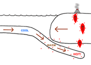
Also, while scientists general agree that hot spots are fixed in position relative to the faster moving overriding plates, some recent studies have shown that hot spots can migrate slowly over geologic time. In any case, the Hawaiian hot spot partly melts the region just below the overriding Pacific Plate, producing small, isolated blobs of molten rock (magma). Less dense than the surrounding solid rock, the magma blobs come together and rise buoyantly through structurally weak zones and ultimately erupt as lava onto the ocean floor to build volcanoes.
The Hawaiian-Emperor Chain
Over a span of about 70 million years, the combined processes of magma formation, eruption, and continuous movement of the Pacific Plate over the stationary hot spot have left the trail of volcanoes across the ocean floor that we now call the Hawaiian-Emperor Chain. A sharp bend in the chain about 2,200 miles northwest of the Island of Hawai'i was previously interpreted as a major change in the direction of plate motion around 43-45 million years ago (Ma), as suggested by the ages of the volcanoes bracketing the bend.
However, recent studies suggest that the northern segment (Emperor Chain) formed as the hot spot moved southward until about 45 Ma, when it became fixed. Thereafter, northwesterly plate movement prevailed, resulting in the formation of the Hawaiian Ridge "downstream" from the hotspot.
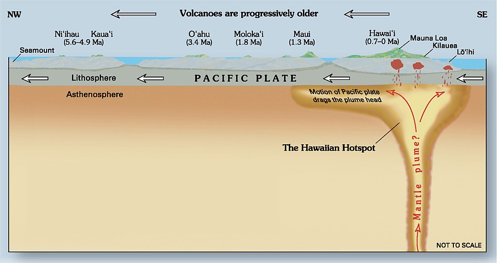
Hawaiian Hot Spot: A cutaway view along the Hawaiian island chain showing the inferred mantle plume that has fed the Hawaiian hot spot on the overriding Pacific Plate. The geologic ages of the oldest volcano on each island (Ma = millions of years ago) are progressively older to the northwest, consistent with the hot spot model for the origin of the Hawaiian Ridge-Emperor Seamount Chain. Modified from image of Joel E. Robinson, USGS, in "This Dynamic Planet" map of Simkin and others, 2006.
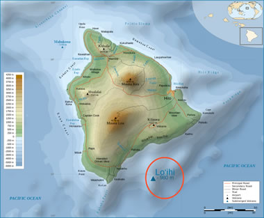
Loihi Seamount: An active submarine volcano off the southern coast of the Big Island of Hawai'i. Creative Commons image by Kmusser. Click to enlarge.
Age of the Islands
The Island of Hawai'i is the southeasternmost and youngest island in the chain. The southeasternmost part of the Island of Hawai'i presently overlies the hot spot and still taps the magma source to feed its active volcanoes. Lö'ihi Seamount, the active submarine volcano off the Island of Hawai'i's south coast, may mark the beginning of the zone of magma formation at the southeastern edge of the hot spot. With the possible exception of Maui, the other Hawaiian islands have moved northwestward beyond the hot spot-they were successively cut off from the sustaining magma source and are no longer volcanically active.
The progressive northwesterly drift of the islands from their point of origin over the hot spot is well shown by the ages of the principal lava flows on the various Hawaiian Islands from northwest (oldest) to southeast (youngest), given in millions of years: Ni'ihau and Kaua'i, 5.6 to 3.8; O'ahu, 3.4 to 2.2; Moloka'i, 1.8 to 1.3; Maui, 1.3 to 0.8; and Hawai'i, less than 0.7 and still growing.
Even for the Island of Hawai'i alone, the relative ages of its five volcanoes are compatible with the hot-spot theory (see map, page 3). Kohala, at the northwestern corner of the island, is the oldest, having ceased eruptive activity about 120,000 years ago. The second oldest is Mauna Kea, which last erupted about 4,000 years ago; next is Hualälai, which has had only one eruption (1800-1801) in written history. Lastly, both Mauna Loa and Kïlauea have been vigorously and repeatedly active in the past two centuries. Because it is growing on the southeastern flank of Mauna Loa, Kïlauea is believed to be younger than its huge neighbor.
The size of the Hawaiian hot spot is not well known, but it presumably is large enough to encompass and feed the currently active volcanoes of Mauna Loa, Kïlauea, Lö'ihi and, possibly, also Hualälai and Haleakalä. Some scientists have estimated the Hawaiian hot spot to be about 200 miles across, with much narrower vertical passageways that feed magma to the individual volcanoes.
| More Plate Tectonics |
 |
Teaching Plate Tectonics |
 |
California Earthquake Maps |
 |
What is the San Andreas Fault? |
 |
The East Africa Rift System |
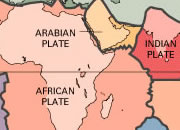 |
Plate Tectonics Map |
 |
What Is The Moho? |
 |
Gifts That Rock |
 |
How did the Hawaiian Islands Form? |

Find Other Topics on Geology.com:

|

| ||

|

| ||

|

| ||

|

|