Home » World Maps » Africa » South Africa
South Africa Map and Satellite Image

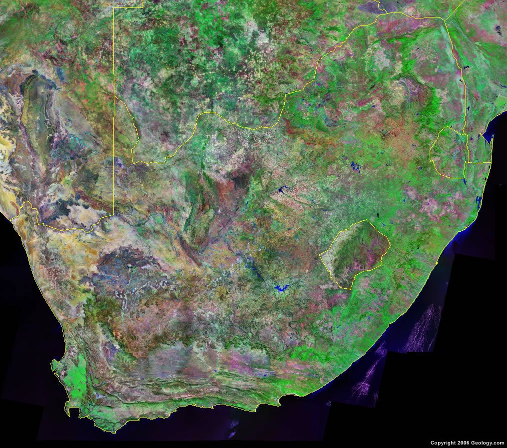
| South Africa is located in southern Africa. South Africa is bordered by the Atlantic Ocean and the Indian Ocean to the south, Namibia, Botswana, Zimbabwe, and Mozambique to the north, and Lesotho and eSwatini (formerly Swaziland) are located within the eastern portion of South Africa. |
ADVERTISEMENT
South Africa Bordering Countries:
Botswana, Lesotho, Mozambique, Namibia, eSwatini (formerly Swaziland), ZimbabweRegional Maps:
Map of Africa, World MapWhere is South Africa?

South Africa Satellite Image
ADVERTISEMENT

Explore South Africa Using Google Earth:
Google Earth is a free program from Google that allows you to explore satellite images showing the cities and landscapes of South Africa and all of Africa in fantastic detail. It works on your desktop computer, tablet, or mobile phone. The images in many areas are detailed enough that you can see houses, vehicles and even people on a city street. Google Earth is free and easy-to-use.
South Africa on a World Wall Map:
South Africa is one of nearly 200 countries illustrated on our Blue Ocean Laminated Map of the World. This map shows a combination of political and physical features. It includes country boundaries, major cities, major mountains in shaded relief, ocean depth in blue color gradient, along with many other features. This is a great map for students, schools, offices and anywhere that a nice map of the world is needed for education, display or decor.
South Africa On a Large Wall Map of Africa:
If you are interested in South Africa and the geography of Africa our large laminated map of Africa might be just what you need. It is a large political map of Africa that also shows many of the continent's physical features in color or shaded relief. Major lakes, rivers, cities, roads, country boundaries, coastlines and surrounding islands are all shown on the map.South Africa Cities:
Alexandria, Beaufort West, Bisho, Bloemfontein, Calvina, Cape Town, De Aar, Dundee, Durban, East London, Golela, Hotazel, Johannesburg, Kimberley, Klerksdorp, Knysna, Kroonstad, Ladysmith, Lephalale (Ellisras), Lichtenburg, Mafikeng, Middelburg, Mokopane (Portgietersrus), Mosselbaai, Musina (Messina), Nelspruit, Nylstroom, Pietermaritzburg, Polokwane (Pietersburg), Port Elizabeth, Port Nolloth, Port Shepstone, Pretoria, Queenstown, Richards Bay, Rustenburg, Saldanha, Sishen, Springbok, Standerton, Stanger, Swellendam, Ulundi, Umtata, Upington, Vanrhynsdorp, Vereeniging, Vryburg, Witbank and Worcester.South Africa Locations:
Algoa Bay, Atlantic Ocean, Cape of Good Hope, False Bay, Groot Vloer, Indian Ocean, Kalahara Desert, Lake Kosi, Lake Saint Lucia, Lake Sibaya, Lebombo Mountains, Limpopo River, Molopo River, Orange (Oranje) River, Outeniqua Mountains, Richards Bay, Saint Francis Bay, Saint Helen Bay, Tugela River, Vaal Dam and Vaal River.South Africa Natural Resources:
Gold, chromium, antimony, coal, iron ore, manganese, nickel, phosphates, tin, uranium, gem diamonds, platinum, copper, vanadium, salt, and natural gas.South Africa Natural Hazards:
There are natural hazards that occur in South Africa, including prolonged droughts.South Africa Environmental Issues:
South Africa has numerous environmental issues. The water issues include: pollution of rivers from urban discharge and agricultural runoff; the growth in water usage is outpacing supply; and, extensive water conservation and control measures are necessary due to a lack of important arterial rivers or lakes. The country has soil erosion and desertification. In addition, there is air pollution which is resulting in acid rain.
ADVERTISEMENT