Home » US Maps » Louisiana » Lakes and Rivers
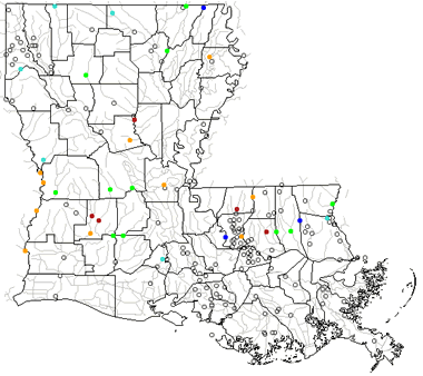
Louisiana Lakes, Rivers and Water Resources

ADVERTISEMENT
Louisiana Rivers Shown on the Map: Amite River, Atchafalaya River, Bayou Bartholomew, Bayou Macon, Bayou Teche, Black Lake Bayou, Black River, Boeuf River, Bogue Chitto, Calcasieu River, Castor Creek, Dugdemona River, Little River, Mermentau River, Mississippi River, Ouachita River, Pearl River, Red River, Sabine River, Tangipahoa River, Tensas River and Whiskey Chitto.
Louisiana Lakes Shown on the Map: Bayou D' Arbonne Lake, Caddo Lake, Calcasieu Lake, Catahoula Lake, Claiborne Lake, Cross Lake, Grand Lake, Lac des Allemands, Lake Bistinea, Lake Maurepas, Lake Pontchatrain, Lake Salvador, Sabine Lake, Toledo Bend Reservoir and White Lake.
| Louisiana Stream and River Levels |
 The United States Geological Survey has a number of stream gages located throughout Louisiana. These estimate stream levels, discharges and record them over time. This data is published on the web and many stations allow users to plot custom graphs. Get updated Louisiana river and stream levels from USGS here.
| Louisiana Stream and River Level Alerts |
 The United States Geological Survey has a system that will send you an email message when flood levels are reached on any stream with USGS gaging equipment that you have selected. Sign up here to receive Louisiana stream and river level alerts.

| Louisiana Drought Map |
 The United States Geological Survey publishes updated drought maps on their website. There you can view a map that shows where below normal 7-day average stream flow conditions were recently recorded. The maps are updated daily. Get a current Louisiana drought map here.
| Louisiana Water Publications |
 The United States Geological Survey has a number of publications related to water use and water resources in Louisiana. Visit the Lower Mississippi-Gulf Water Science Center here.
| Louisiana Elevation Map |
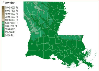 The topography of an area determines the direction of stream flow and often is a primary influence on the geographic distribution of precipitation. View a detailed Louisiana elevation map.


Find Other Topics on Geology.com:

|

| ||

|

| ||

|

| ||

|

|