Home » Satellite Images » US States » Tennessee
Satellite Image of Tennessee
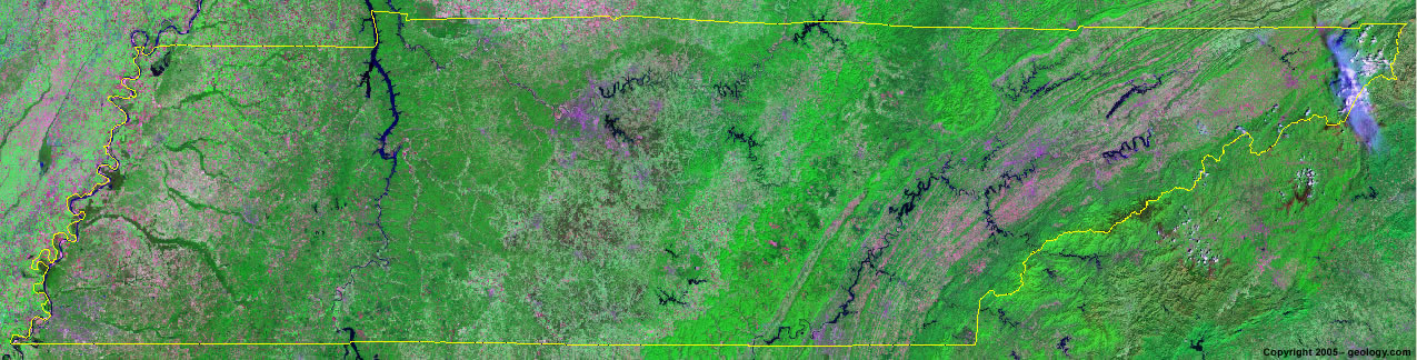
Tennessee Satellite Image - View Cities, Rivers, Lakes & Environment
Satellite Images for Neighboring States:
Alabama Arkansas Georgia Kentucky Mississippi Missouri North Carolina VirginiaThis is a Landsat GeoCover 2000 satellite image map of Tennessee. Cities, rivers, lakes, mountains and other features shown in this image include:
Tennessee Cities:
Bristol, TN
Chattanooga, TN
Clarksville, TN
Dyersburg, TN
Jackson, TN
Kingsport, TN
Knoxville, TN
Maryville, TN
Memphis, TN
Murfreesboro, TN
Nashville, TN
Tennessee Rivers, Lakes, Water Features:
Center Hill Lake
Cherokee Lake
Chickamauga Lake
Clinch River
Cordell Hull Lake
Cumberland River
Dale Hollow Lake
Douglas Lake
Duck River
Forked Deer River
Hatchie River
Hiwassee River
J. Percy Priest Lake
Kentucky Lake
Lake Barkley
Mississippi River
Normandy Lake
Norris Lake
Obion River
Old Hickory Lake
Pickwick Lake
Tellico Lake
Tennessee River
Tims Ford Reservoir
Watts Bar Lake
Woods Reservoir
Other Prominent Tennessee Features:
Appalachian Mountains
Great Smoky Mountains
Tennessee farm land
Unicoi Mountains
ADVERTISEMENT
More Satellite Images
 State Satellite Images: Color Landsat views of all 50 states. Spectacular images.
 Use Google Earth for FREE: Browse seamless worldwide satellite images. Free.
 Earth from Space at Night: Composite images show worldwide patterns of night light and heat.
 Oil & Gas Fields from Space at Night: Drill pad lighting and flaring make them stand out at night.
 Country Satellite Images: Satellite images for over 170 countries from Landsat GeoCover data.
  Satellite Views of US Cities: Images of 120 cities and their surrounding environment.
 Land Below Sea Level: The top ten locations where land is below the level of the ocean.
  Satellite Views of 64 World Cities: Spectacular images showing the city and surrounding environment.
Copyright information: The images on this page were composed by Angela King and are copyright by Geology.com. These images are not available for use beyond our websites. If you would like to share them with others, please link to this page. The satellite image was produced using Landsat data from NASA.