Home » US Maps » Colorado » County Map
Colorado County Map with County Seat Cities

ADVERTISEMENT
County Maps for Neighboring States:
Arizona Kansas Nebraska New Mexico Oklahoma Utah Wyoming
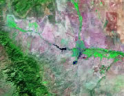


The map above is a Landsat satellite image of Colorado with County boundaries superimposed. We have a more detailed satellite image of Colorado without County boundaries.


ADVERTISEMENT
Colorado Counties and County Seats |
|
|
Adams County - Brighton Alamosa County - Alamosa Arapahoe County - Littleton Archuleta County - Pagosa Springs Baca County - Springfield Bent County - Las Animas Boulder County - Boulder Broomfield County - Broomfield Chaffee County - Salida Cheyenne County - Cheyenne Wells Clear Creek County - Georgetown Conejos County - Conejos Costilla County - San Luis Crowley County - Ordway Custer County - Westcliffe Delta County - Delta Denver County - Denver Dolores County - Dove Creek Douglas County - Castle Rock Eagle County - Eagle El Paso County - Colorado Springs Elbert County - Kiowa Fremont County - Cañon City Garfield County - Glenwood Springs Gilpin County - Central City Grand County - Hot Sulphur Springs Gunnison County - Gunnison Hinsdale County - Lake City Huerfano County - Walsenburg Jackson County - Walden Jefferson County - Golden Kiowa County - Eads |
Kit Carson County - Burlington La Plata County - Durango Lake County - Leadville Larimer County - Fort Collins Las Animas County - Trinidad Lincoln County - Hugo Logan County - Sterling Mesa County - Grand Junction Mineral County - Creede Moffat County - Craig Montezuma County - Cortez Montrose County - Montrose Morgan County - Fort Morgan Otero County - La Junta Ouray County - Ouray Park County - Fairplay Phillips County - Holyoke Pitkin County - Aspen Prowers County - Lamar Pueblo County - Pueblo Rio Blanco County - Meeker Rio Grande County - Del Norte Routt County - Steamboat Springs Saguache County - Saguache San Juan County - Silverton San Miguel County - Telluride Sedgwick County - Julesburg Summit County - Breckenridge Teller County - Cripple Creek Washington County - Akron Weld County - Greeley Yuma County - Wray |
