Home » US Maps » Louisiana » Parish Map
Louisiana Parish Map with Parish Seat Cities

ADVERTISEMENT
County Maps for Neighboring States:
Arkansas Mississippi Texas
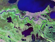


The map above is a Landsat satellite image of Louisiana with Parish boundaries superimposed. We have a more detailed satellite image of Louisiana without Parish boundaries.


ADVERTISEMENT
Louisiana Parishes and Administrative Cities |
|
|
Acadia Parish - Crowley Allen Parish - Oberlin Ascension Parish - Donaldsonville Assumption Parish - Napoleonville Avoyelles Parish - Marksville Beauregard Parish - De Ridder Bienville Parish - Arcadia Bossier Parish - Benton Caddo Parish - Shreveport Calcasieu Parish - Lake Charles Caldwell Parish - Columbia Cameron Parish - Cameron Catahoula Parish - Harrisonburg Claiborne Parish - Homer Concordia Parish - Vidalia De Soto Parish - Mansfield East Baton Rouge Parish - Baton Rouge East Carroll Parish - Lake Providence East Feliciana Parish - Clinton Evangeline Parish - Ville Platte Franklin Parish - Winnsboro Grant Parish - Colfax Iberia Parish - New Iberia Iberville Parish - Plaquemine Jackson Parish - Jonesboro Jefferson Parish - Gretna Jefferson Davis Parish - Jennings La Salle Parish - Jena Lafayette Parish - Lafayette Lafourche Parish - Thibodaux Lincoln Parish - Ruston Livingston Parish - Livingston |
Madison Parish - Tallulah Morehouse Parish - Bastrop Natchitoches Parish - Natchitoches Orleans Parish - New Orleans Ouachita Parish - Monroe Plaquemines Parish - Pointe a la Hache Pointe Coupee Parish - New Roads Rapides Parish - Alexandria Red River Parish - Coushatta Richland Parish - Rayville Sabine Parish - Many St. Bernard Parish - Chalmette St. Charles Parish - Hahnville St. Helena Parish - Greensburg St. James Parish - Convent St. John the Baptist Parish - Edgard St. Landry Parish - Opelousas St. Martin Parish - St. Martinville St. Mary Parish - Franklin St. Tammany Parish - Covington Tangipahoa Parish - Amite Tensas Parish - St. Joseph Terrebonne Parish - Houma Union Parish - Farmerville Vermilion Parish - Abbeville Vernon Parish - Leesville Washington Parish - Franklinton Webster Parish - Minden West Baton Rouge Parish - Port Allen West Carroll Parish - Oak Grove West Feliciana Parish - St. Francisville Winn Parish - Winnfield |
