Home » US Maps » Montana » County Map
Montana County Map with County Seat Cities

ADVERTISEMENT
County Maps for Neighboring States:
Idaho North Dakota South Dakota Wyoming
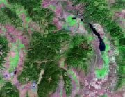


The map above is a Landsat satellite image of Montana with County boundaries superimposed. We have a more detailed satellite image of Montana without County boundaries.


ADVERTISEMENT
Montana Counties and County Seats |
|
|
Beaverhead County - Dillon Big Horn County - Hardin Blaine County - Chinook Broadwater County - Townsend Carbon County - Red Lodge Carter County - Ekalaka Cascade County - Great Falls Chouteau County - Fort Benton Custer County - Miles City Daniels County - Scobey Dawson County - Glendive Deer Lodge County - Anaconda Fallon County - Baker Fergus County - Lewistown Flathead County - Kalispell Gallatin County - Bozeman Garfield County - Jordan Glacier County - Cut Bank Golden Valley County - Ryegate Granite County - Philipsburg Hill County - Havre Jefferson County - Boulder Judith Basin County - Stanford Lake County - Polson Lewis and Clark County - Helena Liberty County - Chester Lincoln County - Libby Madison County - Virginia City |
McCone County - Circle Meagher County - White Sulphur Springs Mineral County - Superior Missoula County - Missoula Musselshell County - Roundup Park County - Livingston Petroleum County - Winnett Phillips County - Malta Pondera County - Conrad Powder River County - Broadus Powell County - Deer Lodge Prairie County - Terry Ravalli County - Hamilton Richland County - Sidney Roosevelt County - Wolf Point Rosebud County - Forsyth Sanders County - Thompson Falls Sheridan County - Plentywood Silver Bow County - Butte Stillwater County - Columbus Sweet Grass County - Big Timber Teton County - Choteau Toole County - Shelby Treasure County - Hysham Valley County - Glasgow Wheatland County - Harlowton Wibaux County - Wibaux Yellowstone County - Billings |
