Home » US Maps » Ohio » County Map
Ohio County Map with County Seat Cities

ADVERTISEMENT
County Maps for Neighboring States:
Indiana Kentucky Michigan Pennsylvania West Virginia
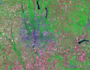


The map above is a Landsat satellite image of Ohio with County boundaries superimposed. We have a more detailed satellite image of Ohio without County boundaries.


ADVERTISEMENT
Ohio Counties and County Seats |
|
|
Adams County - West Union Allen County - Lima Ashland County - Ashland Ashtabula County - Jefferson Athens County - Athens Auglaize County - Wapakoneta Belmont County - Saint Clairsville Brown County - Georgetown Butler County - Hamilton Carroll County - Carrollton Champaign County - Urbana Clark County - Springfield Clermont County - Batavia Clinton County - Wilmington Columbiana County - Lisbon Coshocton County - Coshocton Crawford County - Bucyrus Cuyahoga County - Cleveland Darke County - Greenville Defiance County - Defiance Delaware County - Delaware Erie County - Sandusky Fairfield County - Lancaster Fayette County - Washington Court House Franklin County - Columbus Fulton County - Wauseon Gallia County - Gallipolis Geauga County - Chardon Greene County - Xenia Guernsey County - Cambridge Hamilton County - Cincinnati Hancock County - Findlay Hardin County - Kenton Harrison County - Cadiz Henry County - Napoleon Highland County - Hillsboro Hocking County - Logan Holmes County - Millersburg Huron County - Norwalk Jackson County - Jackson Jefferson County - Steubenville Knox County - Mount Vernon Lake County - Painesville Lawrence County - Ironton |
Licking County - Newark Logan County - Bellefontaine Lorain County - Elyria Lucas County - Toledo Madison County - London Mahoning County - Youngstown Marion County - Marion Medina County - Medina Meigs County - Pomeroy Mercer County - Celina Miami County - Troy Monroe County - Woodsfield Montgomery County - Dayton Morgan County - McConnelsville Morrow County - Mount Gilead Muskingum County - Zanesville Noble County - Caldwell Ottawa County - Port Clinton Paulding County - Paulding Perry County - New Lexington Pickaway County - Circleville Pike County - Waverly Portage County - Ravenna Preble County - Eaton Putnam County - Ottawa Richland County - Mansfield Ross County - Chillicothe Sandusky County - Fremont Scioto County - Portsmouth Seneca County - Tiffin Shelby County - Sidney Stark County - Canton Summit County - Akron Trumbull County - Warren Tuscarawas County - New Philadelphia Union County - Marysville Van Wert County - Van Wert Vinton County - McArthur Warren County - Lebanon Washington County - Marietta Wayne County - Wooster Williams County - Bryan Wood County - Bowling Green Wyandot County - Upper Sandusky |
