Home » US Maps » Indiana » County Map
Indiana County Map with County Seat Cities

ADVERTISEMENT
County Maps for Neighboring States:
Illinois Kentucky Michigan Ohio


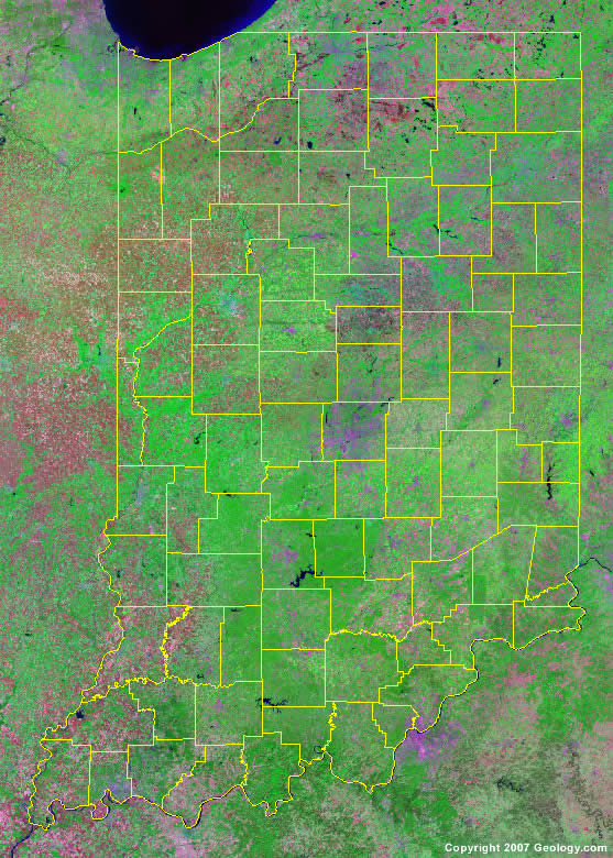
The map above is a Landsat satellite image of Indiana with County boundaries superimposed. We have a more detailed satellite image of Indiana without County boundaries.


ADVERTISEMENT
Indiana Counties and County Seats |
|
|
Adams County - Decatur Allen County - Fort Wayne Bartholomew County - Columbus Benton County - Fowler Blackford County - Hartford City Boone County - Lebanon Brown County - Nashville Carroll County - Delphi Cass County - Logansport Clark County - Jeffersonville Clay County - Brazil Clinton County - Frankfort Crawford County - English Daviess County - Washington Dearborn County - Lawrenceburg Decatur County - Greensburg DeKalb County - Auburn Delaware County - Muncie Dubois County - Jasper Elkhart County - Goshen Fayette County - Connersville Floyd County - New Albany Fountain County - Covington Franklin County - Brookville Fulton County - Rochester Gibson County - Princeton Grant County - Marion Greene County - Bloomfield Hamilton County - Noblesville Hancock County - Greenfield Harrison County - Corydon Hendricks County - Danville Henry County - New Castle Howard County - Kokomo Huntington County - Huntington Jackson County - Brownstown Jasper County - Rensselaer Jay County - Portland Jefferson County - Madison Jennings County - Vernon Johnson County - Franklin Knox County - Vincennes Kosciusko County - Warsaw Lagrange County - Lagrange Lake County - Crown Point LaPorte County - LaPorte |
Lawrence County - Bedford Madison County - Anderson Marion County - Indianapolis Marshall County - Plymouth Martin County - Shoals Miami County - Peru Monroe County - Bloomington Montgomery County - Crawfordsville Morgan County - Martinsville Newton County - Kentland Noble County - Albion Ohio County - Rising Sun Orange County - Paoli Owen County - Spencer Parke County - Rockville Perry County - Tell City Pike County - Petersburg Porter County - Valparaiso Posey County - Mount Vernon Pulaski County - Winamac Putnam County - Greencastle Randolph County - Winchester Ripley County - Versailles Rush County - Rushville St. Joseph County - South Bend Scott County - Scottsburg Shelby County - Shelbyville Spencer County - Rockport Starke County - Knox Steuben County - Angola Sullivan County - Sullivan Switzerland County - Vevay Tippecanoe County - Lafayette Tipton County - Tipton Union County - Liberty Vanderburgh County - Evansville Vermillion County - Newport Vigo County - Terre Haute Wabash County - Wabash Warren County - Williamsport Warrick County - Boonville Washington County - Salem Wayne County - Richmond Wells County - Bluffton White County - Monticello Whitley County - Columbia City |
