Home » Rocks » Oil Shale » Canada
Canada Oil-Shale Deposits
Reprint of: United States Geological Survey Scientific Investigations Report 2005-5294
By John R. Dyni
Canada's oil-shale deposits range from Ordovician to Cretaceous age and include deposits of lacustrine and marine origin; as many as 19 deposits have been identified (Macauley, 1981; Davies and Nassichuk, 1988). During the 1980s, a number of the deposits were explored by core drilling (Macauley, 1981, 1984a, 1984b; Macauley and others, 1985; Smith and Naylor, 1990). Investigations included geologic studies, Rock-Eval and X-ray diffraction analyses, organic petrology, gas chromatography and mass spectrometry of the shale oil, and hydroretorting analyses.
The oil shales of the New Brunswick Albert Formation, lamosites of Mississippian age, have the greatest potential for development. The Albert oil shale averages 100 l/t of shale oil and has potential for recovery of oil and may also be used for co-combustion with coal for electric power generation.
Marinites, including the Devonian Kettle Point Formation and the Ordovician Collingwood Shale of southern Ontario, yield relatively small amounts of shale oil (about 40 l/t), but the yield can be doubled by hydroretorting. The Cretaceous Boyne and Favel marinites form large resources of low-grade oil shale in the Prairie Provinces of Manitoba, Saskatchewan, and Alberta. Upper Cretaceous oil shales on the Anderson Plain and the Mackenzie Delta in the Northwest Territories have been little explored, but may be of future economic interest.
Outcrops of Lower Carboniferous lacustrine oil shale on Grinnell Peninsula, Devon Island, in the Canadian Arctic Archipelago, are as much as 100 m thick and samples yield up to 387 kilograms of shale oil per ton of rock by Rock-Eval (equivalent to about 406 l/t). For most Canadian deposits, the resources of in-situ shale oil remain poorly known.
New Brunswick Oil Shale
The oil-shale deposits of the lacustrine Albert Formation of Mississippian age are located in the Moncton sub-basin of the Fundy Basin that lies roughly between St. Johns and Moncton in southern New Brunswick. The principal part of the deposit lies at the east end of the sub-basin at Albert Mines about 25 km south-southeast of Moncton, where one borehole penetrated more than 500 m of oil shale. However, complex folding and faulting obscure the true thickness of the oil-shale beds, which may be much thinner.
The richest part of the sequence, the Albert Mines zone, measures about 120 m thick in one borehole, which may be double the true stratigraphic thickness because of structural complexity as noted above. The shale-oil yield ranges from less than 25 to more than 150 l/t; the average specific gravity is 0.871. Shale-oil reserves for the Albert Mines zone, which yields an estimated 94 l/t of shale oil by Fischer assay, is estimated at 67 million barrels. The shale-oil resource for the entire oil-shale sequence is estimated at 270 million barrels (Macauley and others, 1984), or about 37 million tons of shale oil.
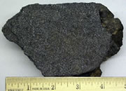
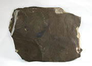
The oil shale consists of interbedded dolomitic marlstone, laminated marlstone, and clayey marlstone. The mineral matrix is composed of dolomite, local calcite, and minor siderite with quartz, feldspar, some analcime, abundant illite, and minor amounts of smectite. The presence of dolomite and analcime, as well as the presence of overlying beds of halite, indicates that the oil shale was probably deposited in an alkaline saline lake.
The first commercial development was of a single vein of albertite, a solid hydrocarbon cutting across the oil-shale deposits, that was mined from 1863 to 1874 to a depth of 335 m. During that period, 140,000 tons of albertite were sold in the U.S. for $18/ton. A 41-ton sample sent to England in the early 1900s yielded 420 l/t and 450 m3 of methane gas/ton of albertite. In 1942 the Canadian Department of Mines and Resources initiated a core-drilling program to test the deposit. A total of 79 boreholes were drilled and a resource of 91 million tons of oil shale above a depth of 122 m was estimated. The grade of the oil shale averaged 44.2 l/t. An additional 10 boreholes were drilled by Atlantic-Richfield Company in 1967-68 to test the deeper oil shales, and still further exploration drilling was carried out by Canadian Occidental Petroleum, Ltd. in 1976 (Macauley, 1981).

Find Other Topics on Geology.com:
 | Rocks: Galleries of igneous, sedimentary and metamorphic rock photos with descriptions. |
|
 | Minerals: Information about ore minerals, gem materials and rock-forming minerals. |
|
 | Volcanoes: Articles about volcanoes, volcanic hazards and eruptions past and present. |
|
 | Gemstones: Colorful images and articles about diamonds and colored stones. |
|
 | General Geology: Articles about geysers, maars, deltas, rifts, salt domes, water, and much more! |
|
 | Geology Store: Hammers, field bags, hand lenses, maps, books, hardness picks, gold pans. |
|

|
 | Diamonds: Learn about the properties of diamond, its many uses, and diamond discoveries.
|
|