Home » Volcanoes » Chaitén Volcano
Chaitén (Chaiten Volcano) - Chile
Article by Jessica Ball
| Picture of a Chaitén Eruption Column |
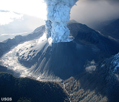
Chaitén volcano: View of an eruption column from Chaitén Volcano, Chile, photographed on May 26, 2008. The caldera is about 3 km (1.9 miles) in diameter from rim to rim. The knobby feature between the eruption column and the left rim is part of a lava dome that formed after the 7,400 BC eruption. U.S. Geological Survey photograph by J.N. Marso.
Chaitén: Introduction
Chaitén is a small volcanic caldera located on the flank of the Michinmahuida volcano in southern Chile. Before 2008, it consisted mainly of a rhyolitic lava dome last active 9,400 years ago. But in May 2008, Chaitén began erupting violently, producing numerous plumes, pyroclastic flows and lahars, and building a new lava dome on the north side of the old one. The eruption has had serious consequences for the nearby town of Chaitén, inundating it with lahars and ash, and ash from the eruption has even disrupted travel and agriculture in surrounding countries.
| Simplified plate tectonics cross section |
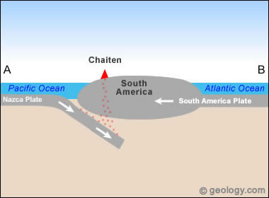
Simplified plate tectonics cross-section showing how Chaitén is located above a subduction zone formed where the Nazca and South America plates collide. In this subduction zone melting produces magma bodies that rise towards the surface. Image by Geology.com.
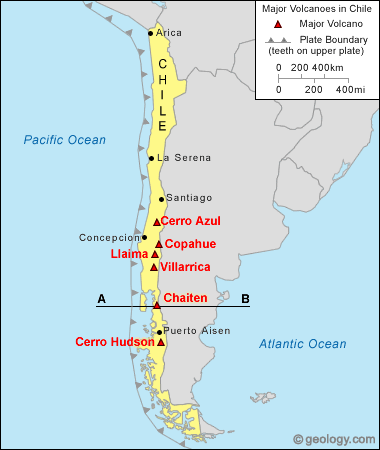
Chaitén volcano map: Map showing the location of Chaitén Volcano near the west coast of South America. The thin line labeled A-B marks the location of the simplified plate tectonics cross section shown below. Map by Geology.com and MapResources.
Chaitén: Plate Tectonic Setting
Chaitén sits above the Peru-Chile subduction zone. In this convergent boundary, the Nazca Plate is being subducted under the South America tectonic plate. The southern end of the plate dips at a steep angle, while the northern end may be experiencing flat-slab subduction (in which the oceanic slab slides beneath the continental plate at a very low angle). A low angle of subduction may explain the relative lack of volcanic activity in the northern part of Chile, compared to the extremely active southern volcanic mountains.
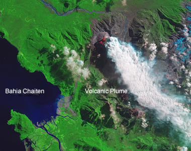
Chaitén ash plume: A view of Chaitén's ash plume. NASA image created by Jesse Allen, using EO-1 ALI data provided courtesy of the NASA EO-1 Team.
Chaitén Geology and Hazards
Chaitén is a relatively small (3 km wide) volcanic caldera located on the western flank of the Michinmahuida volcano. Before the May 2008 eruption began, it contained a rhyolitic obsidian lava dome and several small lakes. The caldera is breached on its SW side by a river that drains to the bay of Chaitén, past the town of Chaitén on the Gulf of Corcovado.
Prior to the current eruption, 9,400-year-old volcanic deposits indicated that the volcano was capable of producing pyroclastic surges, pumice flows, and tephra fallout. When the volcano began erupting in May 2008, it produced high Plinian eruption columns of ash, gas and rock. These columns were accompanied by pyroclastic flows, lahars, and abundant ashfall. Though the area around Chaitén is sparsely populated, more than 5000 people had to be evacuated from nearby towns, and aviation in southern South America was disrupted for weeks. Within 10 days of the first eruption, lahars had overrun much of the town of Chaitén. The Chilean government later ordered the complete evacuation of the town, and is currently planning to relocate the town entirely.
Chaitén is a major concern to both the airline industry and the neighboring country of Argentina. The volcano's eruption columns have reached 15 km (50,000 ft) in height, which is almost twice a jet's normal cruising altitude (about 30,000 feet). In the first week of the current eruption, five airplanes encountered eruption-cloud ash, and several sustained significant engine damage. Airports in Chile, Argentina and Uruguay, up to 2,300 km from the volcano, were forced to close or cancel flights. In addition, volcanic ash from the eruption clouds has caused ground transportation and health problems in Chile and Argentina.
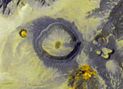
| Chaitén Pre-Eruption Lava Dome |
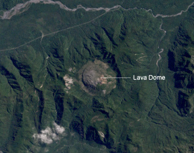
Chaitén lava dome: A view of Chaitén's lava dome. NASA image created by Robert Simmon, using Landsat data provided by the University of Maryland's Global Land Cover Facility.
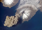
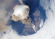
| Chaitén and Michinmahuida |
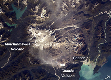
Chaitén and Michinmahuida: This astronaut photograph highlights two volcanoes located near the southern boundary of the Nazca-South America subduction zone in southern Chile. Dominating the scene is the massive Michinmahuida Volcano (also spelled Minchinmávida; image upper right). Charles Darwin observed an eruption of this glaciated volcano during his Galapagos Islands voyage in 1834; the last recorded eruption took place the following year. When this photo was taken, the white, snow-covered summit of Michinmahuida was blanketed by gray ash erupted from its much smaller but now-active neighbor to the west, Chaitén Volcano. Image from Image Science and Analysis Laboratory, NASA-Johnson Space Center. "The Gateway to Astronaut Photography of Earth."
Chaitén: Eruption History
Prior to the May 2008 eruption, the most recent eruption of Chaitén occurred 9,400 years ago. It created pyroclastic surge and pumice flow deposits, and formed the rhyolitic obidian lava dome in the central crater. However, on Friday, May 2, 2008, the volcano suddenly erupted, producing a plume of volcanic ash and steam that rose nearly 17 kilometers high and was visible on satellite images for hundreds of kilometers over the Atlantic. The town of Chaitén, located about 10 kilometers southwest of the eruption site, was blanketed with ash. About 4,000 people who lived there were evacuated by boat. The town of Futaleufu, with about 1,000 residents, was also evacuated. Smaller communities to the southeast such as Chubut and Rio Negro also received heavy ashfalls. The ash plume was so thick in some parts of Argentina that schools, highways and airports were forced to close.
Facts About Chaitén |
| Location: |
Southern Chile |
| Coordinates: |
42.833oS, 72.646oW |
| Elevation: |
1122 m (3,681 ft) |
| Volcano Type: |
Caldera |
| Last Eruption: |
2011 |
|
Eruptions have continued since then, creating many high ash-and-gas plumes, and resulting in the extrusion of a new lava dome on the north side of the old dome. This dome-building eruption is accompanied by constant degassing, ash and steam emission, gravitational collapses of unstable parts of the new dome (which result in pyroclastic flows), lahars, and some seismicity. A central spine of lava has been pushed out of the new dome, but will likely collapse, as such features are typically very unstable and short-lived. While seismicity seems to be decreasing, which may indicate that the dome growth rate is slowing, the danger of collapses and lahars still remains.
-- Obsidian cobbles from the 7,400 BC lava dome were used by prehistoric peoples to create artifacts that are found as far as 400 km away from the volcano. Obsidian blades transported by an ancient maritime canoe culture to the north and south of the volcano have been discovered in sites that date to as far back as 5,610 years before present. Knowing this date helped geologists establish a minimum age for the formation of the obsidian lava dome.
-- The latest eruption of Chaitén spurred Chile's geological survey (the Servicio Nacional de Geología y Minería, or SERNAGEOMIN) to create a new program to improve monitoring and hazard mitigation at 43 of Chile's high-threat volcanoes. The program will support studies of the history of eruptions at these volcanoes, assessments of volcanic hazards, and the creation of a real-time monitoring network and early warning system.
|
| More Chaitén Information |
Smithsonian Institution Global Volcanism Program Website: Chaitén page.
SERNAGEOMIN - Servicio Nacional de Geología y Minería. (Spanish)
Ewert, J.W. et al, 2008, The 2008 Eruption of Chaitén Volcano, Chile and National Volcano-Monitoring Programs in the U.S. and Chile, Eos Trans. AGU, 89(53), Fall Meeting Supplement, Abstract V43D-2177.
Guffanti, M. et al., 2008, Widespread Effects on Aviation of the 2008 Eruption of Chaitén Volcano, Chile, Eos Trans. AGU, 89(53), Fall Meeting Supplement, Abstract V42C-03.
|
About the Author
Jessica Ball is a graduate student in the Department of Geology at the State University of New York at Buffalo. Her concentration is in volcanology, and she is currently researching lava dome collapses and pyroclastic flows. Jessica earned her Bachelor of Science degree from the College of William and Mary, and worked for a year at the American Geological Institute in the Education/Outreach Program. She also writes the Magma Cum Laude blog, and in what spare time she has left, she enjoys rock climbing and playing various stringed instruments.

Find Other Topics on Geology.com:
 | Rocks: Galleries of igneous, sedimentary and metamorphic rock photos with descriptions. |
|
 | Minerals: Information about ore minerals, gem materials and rock-forming minerals. |
|
 | Volcanoes: Articles about volcanoes, volcanic hazards and eruptions past and present. |
|
 | Gemstones: Colorful images and articles about diamonds and colored stones. |
|
 | General Geology: Articles about geysers, maars, deltas, rifts, salt domes, water, and much more! |
|
 | Geology Store: Hammers, field bags, hand lenses, maps, books, hardness picks, gold pans. |
|

|
 | Diamonds: Learn about the properties of diamond, its many uses, and diamond discoveries.
|
|