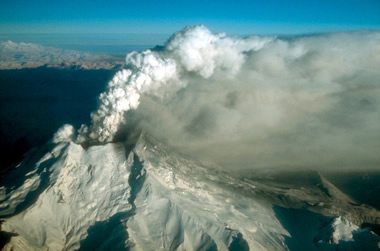
| Redoubt: 1990 Eruption Cloud |
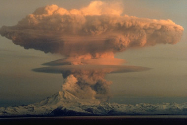
Eruption cloud from Redoubt Volcano as viewed from the Kenai Peninsula. The mushroom-shaped plume rose from avalanches of hot debris (pyroclastic flows) that cascaded down the north flank of the volcano. A smaller, white steam plume rises from the summit crater. Photograph by R. Clucas, April 21, 1990.
Redoubt: Introduction
Redoubt is a steep-sided stratovolcano located at the northeast end of the Aleutian volcanic arc. It is potentially one of the most dangerous volcanoes in Alaska.
Built above the Aleutian subduction zone over the last 890,000 years, Redoubt is now heavily glaciated and boasts an ice-filled summit crater. Its last eruption was in 2009.
Renewed activity would pose a major risk to air traffic in the region around the volcano, and ash from an eruption could reach as far as the continental US.
| Simplified plate tectonics cross-section |
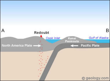
Simplified plate tectonics cross-section showing how Redoubt is located above a subduction zone formed where the Pacific and North America plates collide. The Pacific Plate is melting at depth to feed Redoubt's eruptions. For a more detailed view see Figure 1 in United States Geological Survey Open File Report 00-0365: Eastern Aleutian Volcanic Arc Digital Model.
| Map: Where is Redoubt? |
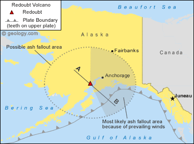
Redoubt map: Map showing the location of Redoubt Volcano in Alaska. The thin line labeled A-B marks the location of the simplified plate tectonics cross-section shown below. Map by Geology.com and MapResources.
| Picture of Redoubt Volcano From Bear Lake |
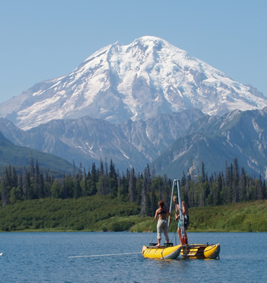
Redoubt Volcano: Coring Bear Lake, about 35 kilometers (22 miles) east of Redoubt Volcano (background). Al Werner and Kristi Wallace of the Alaska Volcano Observatory are using a pontoon boat as a coring platform to recover volcanic ash erupted from Redoubt and other Aleutian Arc volcanoes. Photograph by Caleb Schiff, AVO/USGS.
Redoubt: Plate Tectonic Setting
Redoubt is a subduction zone volcano, deriving its magma from melt created when the Pacific plate dives beneath the North America plate. This subduction zone has created both the Aleutian Trench, about 270 miles to the southeast of the volcano, and the Aleutian volcanic arc, of which Redoubt is a part. Redoubt sits on continental crust over a Mesozoic granitic batholith.
Isotopic data suggests that the volcano's magmas include melted rocks from the North America continental plate as well as the downgoing Pacific Plate and the melting mantle above it.
Redoubt: Geology and Hazards
Redoubt is a steep-sided stratovolcano that began forming about 890,000 years ago. The early stages of its growth were characterized by dacitic explosive eruptions, including pyroclastic flows and lava domes. Later cone-building eruptions, beginning about 340,000 years ago, became less silicic, producing basalt and basaltic andesite lava flows, scoria and ash flows.
The latest cone-building stage saw Redoubt's chemistry becoming more silicic again, with andesite lava and block-and-ash flows and silicic andesite ashfalls. Activity in the last 10,000 years has included a major collapse of the summit which resulted in a debris flow that reached the Cook Inlet, and clay-rich lahars that formed when hot material (most likely ash and gas eruptions) melted parts of the glaciers which cover Redoubt.
| Redoubt: 1989 Steam and Ash Eruption |
Redoubt steam and ash eruption: Aerial view, looking north, of Redoubt Volcano during a continuous, low-level eruption of steam and ash on December 18, 1989. Photograph by W. White, AVO/USGS.
Redoubt's eruptions pose a direct hazard to aircraft, especially in the high-traffic flight paths that pass over the Aleutian volcanic arc. This hazard would be especially dangerous if Redoubt were to erupt, since volcanic ash that reaches the jet stream can be carried for hundreds or thousands of miles.
Ash that enters a hot aircraft engine is quickly melted and resolidifies on moving engine parts as glass, which can cause the engine to flame out or shut down entirely. In 1990, one aircraft that flew through a suspected eruption cloud from an Alaskan volcano experienced a shutdown of all of its engines, and its crew managed to restart them just in time to prevent a deadly crash.
Redoubt is also capable of producing pyroclastic flows and surges, but aside from ash-related hazards, the next most pressing concern of a Redoubt eruption would be lahars. In 1990, lahars initiated by hot erupted material reached the Cook Inlet in only a few hours, and completely shut down the Drift River Oil Terminal.
| Snow and Ice Filled Summit Crater |
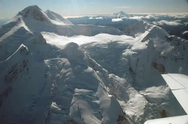
Redoubt summit crater: Snow- and ice-filled summit crater of Redoubt Volcano. View from the northeast. The 1989-90 dome is completely covered and no anomalous holes or steaming were observed on this day. Photograph by Game McGimsey, AVO/USGS.
Redoubt: Eruption History
Redoubt has erupted explosively at least five times since Captain James Cook observed the volcano steaming in 1778. The eruptions have all originated from a vent at the north end of the summit crater. The oldest historical eruption occurred in 1902, when explosions were heard hundreds of kilometers away and extensive ashfall blanketed the Cook Inlet area. Explosive eruptions in the 1960s caused flooding and lahars from melting glaciers, and created ash plumes that reached 6 km in height.
The last eruption of the 20th century began in December 1989 with a short period of intense seismicity and vent-clearing explosions that continued for more than five months. Activity included 23 ash-rich eruptions, pyroclastic and debris flows that entrained glacial ice and caused flooding up to 35 km downstream. The debris flows reached Cook Inlet and temporarily shut down the Drift River Oil Terminal. Lava flows in the crater built several lava domes which were later destroyed by explosions. One final dome grew before the eruption finally ceased in June 1990.
| Did You Know? |
|
-- Redoubt is not the only volcano which threatens aircraft and creates ash-related hazards. Areas where explosive volcanic eruptions are common, such as the Kamchatka Peninsula in Russia, the islands of Indonesia and the Philippines, and the highlands of Central and South America, are constantly being monitored in order to prevent disastrous interaction between aircraft and volcanic clouds.
-- A worldwide organization of Volcanic Ash Advisory Centers (VAACs) exists to monitor and issue warnings about ash and gas clouds created by volcanic eruptions. There are nine VAAC offices, including one in Anchorage, Alaska. They use visual, chemical and thermal satellite data as well as direct visual observations to identify dangerous ash clouds, and issue alerts to aviation control administrations around the world. |
| Map: Cook Inlet Volcanoes |
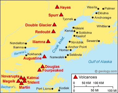
Cook Inlet Volcanoes: Map showing the location of selected volcanoes around Cook Inlet, Alaska. Map by Geology.com and MapResources.
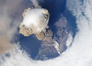
| Redoubt Volcano: One of the 2009 Eruptions |
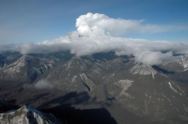
Redoubt eruption: The most recent eruptive activity at Redoubt volcano began on March 22, 2009. There have been many explosive eruptions, ash has blanketed the landscape and floods have swept down the Drift River. In this image an eruption cloud drapes Redoubt and an ash-covered landscape. Photo by Game McGimsey, Alaska Volcano Observatory / U.S. Geological Survey.
| Lahar Deposits in the Drift River Valley |
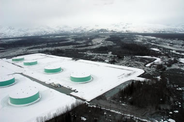
Lahar deposits: Aerial photograph of the Drift River Valley shortly after a March, 2009 eruption. The dark areas are covered with mud delivered by lahars (volcanic mudflows) caused by melting glacial ice on the Redoubt summit. The Drift River Oil Terminal can be seen in this view. Fortunately the lahars did not wipe out the terminal, however they did wash over the protective berm in a few locations. Photo by Game McGimsey, Alaska Volcano Observatory / U.S. Geological Survey.
Eruptive activity at Redoubt - April 20, 2009 - Summarized from bulletins of the Alaska Volcano Observatory:
Following a period of above-background seismicity beginning on January 25, 2009, Redoubt had a minor gas-and-ash explosion on March 15. On March 22, major plinian explosions began at the volcano, and since then more than 19 separate explosions have been recorded. The eruption clouds reached more than 50,000 feet (15 km) above sea level, and forced airlines to reroute their flight paths away from the volcano. Several of Redoubt's eruptions have produced ashfalls up to hundreds of miles away, including areas on the Kenai Peninsula and in Anchorage. On March 28, ashfall in Anchorage forced the airport there to close temporarily.
| |
Large lahars (volcanic mudflows) occurred in late March and early April, and inundated the Drift River Valley and its downstream coastal fan. The lahars also reached the Cook Inlet, where the Drift River Oil Terminal is located, and overtopped the levees meant to protect the facility.
By March 27 a ½ mile wide crater had formed at the summit from one or more of the eruption's early explosions. It is in this crater that an elongated lava dome began forming, and was destroyed by the April 4 eruption. Then another lava dome grew in Redoubt's summit crater. Photography and thermal images showed that the dome, as of April 17, 2009, was about 500 m by 700 m (1640 ft by 1300 ft) in size and at least 50 m (160 ft) thick. The dome growth was accompanied by emissions of volcanic ash and gases.
The Alaska Volcano Observatory cautioned that there would likely be additional cycles of dome-building and explosions in the coming days to months, but their nature and timing are uncertain. They warned that the summit domes could become unstable and produce hot rock avalanches, pyroclastic flows, and ash columns, and melting snow on Redoubt would likely produce more lahars that may threaten downstream areas. In order to better monitor Redoubt's eruptions, scientists at AVO installed several new seismometers, GPS receivers, and a new webcam, and carefully monitored the lava dome, seismic activity, and gas emissions at the volcano.
| Volcanic Lightning at Redoubt Volcano |
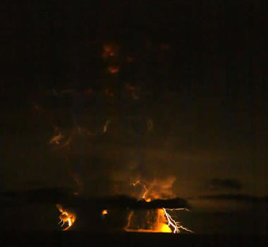
Volcanic Lightning: Lightning that formed in the ash cloud over Redoubt Volcano during an eruption on March 27, 2009. More information. Photo by Bretwood Higman.
About the Author
Jessica Ball is a graduate student in the Department of Geology at the State University of New York at Buffalo. Her concentration is in volcanology, and she is currently researching lava dome collapses and pyroclastic flows. Jessica earned her Bachelor of Science degree from the College of William and Mary, and worked for a year at the American Geological Institute in the Education/Outreach Program. She also writes the Magma Cum Laude blog, and in what spare time she has left, she enjoys rock climbing and playing various stringed instruments.
| More Information on Redoubt |
|
Smithsonian Institution Global Volcanism Program Website: Redoubt page.
USGS Alaska Volcano Observatory Website: Redoubt Activity Page. Gates, A.E. and Ritchie, D., 2007, Encyclopedia of Earthquakes and Volcanoes, Third Edition: New York, NY, Checkmark Books, 346 p. National Oceanic and Atmospheric Administration: Volcanic Ash Advisory Centers Page. USGS Open-File Report 2005-1310: 2003 Volcanic Activity in Alaska and Kamchatka: Summary of Events and Response of the Alaska Volcano Observatory. USGS Open-File Report 97-857: Preliminary Volcano-Hazard Assessment for Redoubt Volcano, Alaska. USGS Open-File Report 98-0582: Catalog of the Historically Active Volcanoes of Alaska. |
| More Volcanoes |
 |
Where Are the Canary Islands? |
 |
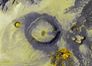
Mount Cleveland |
 |
Solar System Volcanoes |
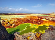 |
Dallol Volcano |
 |
What is a Maar? |
 |
Spectacular Eruption Photos |
 |
Stromboli Volcano |
 |
Mount St. Helens |

Find Other Topics on Geology.com:

|

| ||
|

| ||

|

| ||

|

|