Home » World Maps » United Kingdom » South Georgia and South Sandwich Islands
South Georgia and South Sandwich Islands Map and Satellite Image
| The South Georgia and The South Sandwich Island groups are remote islands in the South Atlantic Ocean. These islands are uninhabited, but there is a small non-permanent population that serves tourism and makes scientific observations. Together the island groups are a British Overseas Territory.
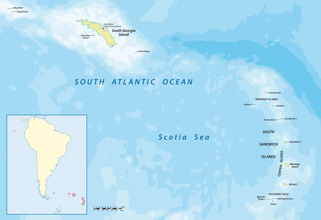
The South Georgia Island Group is located about 800 miles (1,300 kilometers) east-southeast of the Falkland Islands and about 900 miles (1,450 kilometers) east-northeast of the tip of the Antarctic Peninsula. There are no scheduled passenger flights or ferries serving the islands. To appreciate the expansiveness of the Territory, the distance between South Georgia Island and the nearest South Sandwich island is about 430 miles (700 kilometers). The distance between Zavodovski Island (the northernmost South Sandwich Island) and Cook Island (the southernmost island) is about 215 miles (about 350 kilometers). These remote islands are separated by some of the roughest seas in the world's oceans and are in one of the world's most difficult climates. Map by Rainer Lesniewski / iStockphoto. |
ADVERTISEMENT
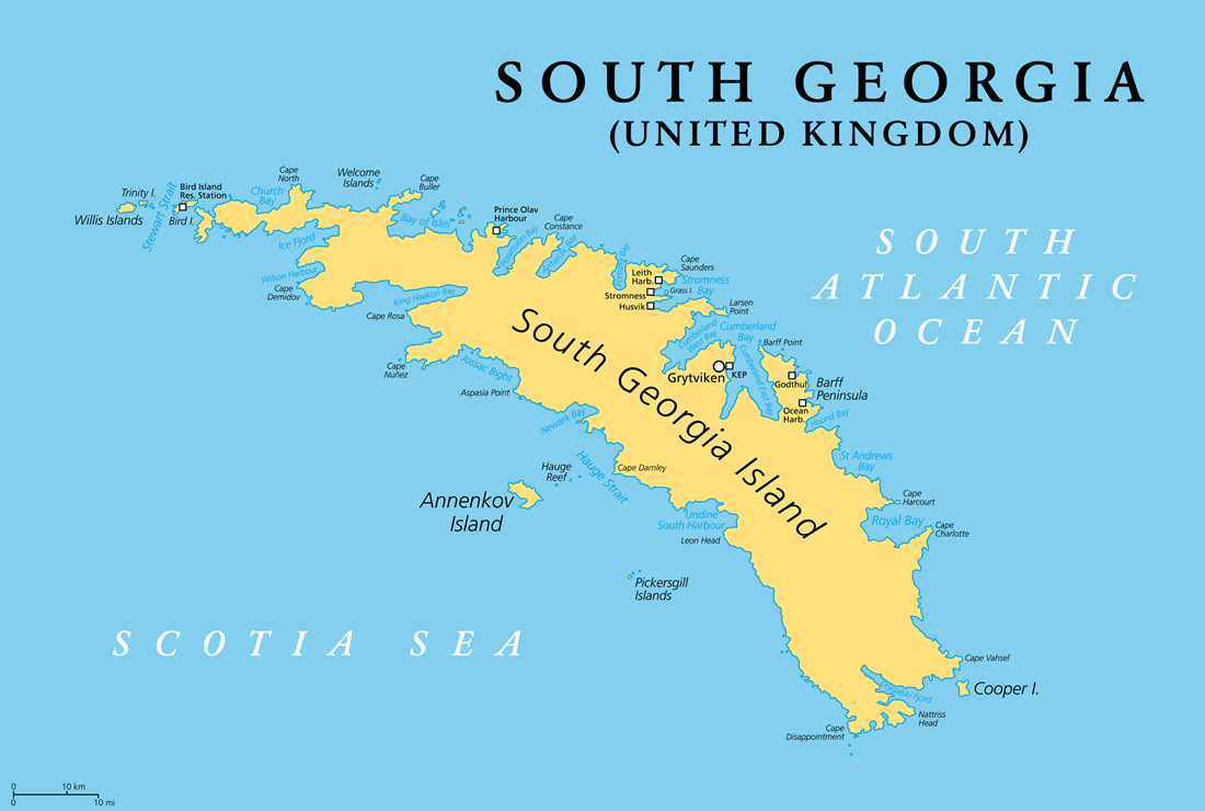
| The South Georgia Island Group is an archipelago between the South Atlantic Ocean and the Scotia Sea. It consists of a main island (South Georgia Island) and a large number of smaller islands and islets. The largest of these smaller islands is Annenkov Island off the southwest coast of South Georgia Island. Next in size is Cooper Island off the southeast tip of South Georgia Island.
Off the northwest coast of South Georgia Islands is the Willis Islands Group, consisting of Main Island, Trinity Island, Vaughan Island, the Verdant Islands, Hall Island, Proud Island, and numerous smaller islands, islets, and rocks. Across the Stewart Strait is Bird Island, just two miles off the northwest coast of South Georgia Island. The Welcome Islands and the Bay of Isles Islands are off the north coast of South Georgia Island. The Pickersgill Islands and Hauge Reef islets are off the southwest coast. Two small clusters of rocks mark the westernmost and easternmost parts of the South Georgia Island Group. Shag Rocks is the westernmost cluster. They are a group of six small rock islets about 150 miles (240 kilometers) off the northwest tip of South Georgia Island. Clerke Rocks is the easternmost cluster. They are another small cluster of rocky islets about 35 miles (56 kilometers) off the southeastern tip of South Georgia Island. Numerous other small islands, islets and rocks are part of the South Georgia Island Group. Map by Peter Hermes Furian / iStockphoto. |
ADVERTISEMENT
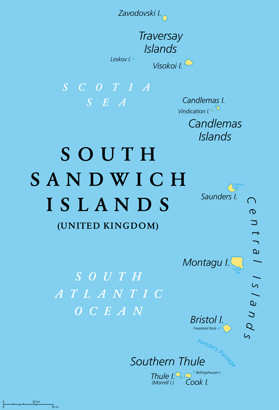
| The South Sandwich Islands were named after John Montagu, the 4th Earl of Sandwich. They were called the "South" Sandwich Islands to keep them from being confused with the Hawaiian Islands, which were at one time called the "Sandwich Islands". All of these islands are volcanic in origin because they sit atop of the Scotia Plate, directly above the Scotia subduction zone, where the edge of the descending South American Plate is melting.
The South Sandwich Islands are made up of four small island groups: 1) The Traversay Islands are the northernmost island group. They are (from north to south) Zavodovski Island, Leskov Island, and Visokoi Island. 2) The Candlemas Islands are south of the Traversay Islands. They are Candlemas Island and Vindication Island. 3) The Central Islands are Saunders Island, Montagu Island, and Bristol Island. 4) The Southern Thule Islands are Thule Island, Bellingshausen Island, and Cook Island. Map by Peter Hermes Furian / iStockphoto. |
ADVERTISEMENT
South Georgia and South Sandwich Islands Neighboring Island Groups:
Falkland IslandsRegional Maps:
Argentina, South America, Antarctica, World MapWhere are the South Georgia and South Sandwich Islands?
South Georgia Island Satellite Image
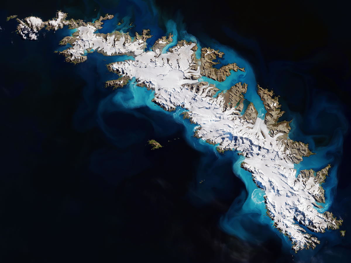
| The image above is a summer view of South Georgia Island. Most of the island remains covered in snow throughout the year. Glaciers, rather than streams, flow down most of the valleys.
At this time of year, meltwater flows off of the island and into the surrounding ocean waters. The melt water carries suspended sediment which, from the view of a satellite on a sunny day, gives the water a bright turquoise color. Data for the satellite image above was acquired in 2018 by the Copernicus Sentinel-2 satellite and the European Space Agency. Image by Claudia Weinmann / Alamy Stock Photo. Click for a larger view. |
ADVERTISEMENT

Explore the South Georgia and South Sandwich Islands Using Google Earth:
Google Earth is a free program from Google that allows you to explore satellite images showing the settlements and landscapes of the South Georgia and South Sandwich Islands and the rest of the world in fantastic detail. It works on your desktop computer, tablet, or mobile phone. The images in many areas are detailed enough that you can see houses, vehicles and even people on a city street. Google Earth is free and easy-to-use.
South Georgia and South Sandwich Islands on a World Wall Map:
The South Georgia and South Sandwich Islands are included on our Blue Ocean Laminated Map of the World. This map shows a combination of political and physical features. It includes country boundaries, major cities, major mountains in shaded relief, ocean depth in blue color gradient, along with many other features. This is a great map for students, schools, offices, and anywhere that a nice map of the world is needed for education, display or decor.
South Georgia and South Sandwich Islands On a Large Wall Map of South America:
If you are interested in the South Georgia and South Sandwich Islands and the geography of South America, our large laminated map of South America might be just what you need. It is a large political map of South America that also shows many of the continent's physical features in color or shaded relief. Major lakes, rivers, cities, roads, country boundaries, coastlines and surrounding islands are all shown on the map.South Georgia and South Sandwich Islands Settlements:
On South Georgia Island, there is a research facility at Grytviken / King Edward Point that is staffed by about 20 people from the British Antarctic Survey. The South Sandwich Islands are uninhabited.South Georgia and South Sandwich Islands Named Islands:
South Georgia is the largest island of the territory, with a width of 103 miles (165 km). Its surrounding islands and islets include Annenkov Island, the Willis Islands, Bird Island, Welcome Islands, Grass Island, Hague Reef, Pickersgill Islands, Cooper Island, Clerke Rocks, Blag Rock, and Shag Rocks.The South Sandwich Islands are separated into 4 groups: The Traversay Islands, the Candlemas Islands, the Central Islands, and Southern Thule. The Traversay Islands include Zavodovski, Leskov, and Visokoi. The Candlemas Islands include Candlemas and Vindication. The Central Islands include Saunders, Montagu, and Bristol. Southern Thule includes Thule (Morrell), Cook, and Bellingshausen.
South Georgia and South Sandwich Islands Locations:
There are research facilities located on Bird Island. On South Georgia Island, there is a research station at King Edward Point, and field camps at St. Andrews Bay, Schlieper Bay, and Lyell Glacier. Historic whaling settlements include Prince Olav Harbour, Leith Harbour, Stromness, Husvik, Godthul, and Ocean Harbour.South Georgia and South Sandwich Islands Natural Resources:
The Patagonian toothfish is such an important natural resource that September 4 was designated "Toothfish Day" - a public holiday to celebrate the end of the fishing season.South Georgia and South Sandwich Islands Natural Hazards:
The islands are mountains, barren, and permanently covered with ice and snow. Some of the South Sandwich islands are historically active volcanoes. Mount Michael, located on Saunders Island, has a persistent lava lake, which is an uncommon geologic phenomenon.
ADVERTISEMENT