Home » World Maps » Australia » Tuvalu
Tuvalu Map and Satellite Image

| Tuvalu is an island country and an archipelago in the South Pacific Ocean, roughly halfway between Australia and Hawaii. Map by dikobraziy / iStockphoto. |
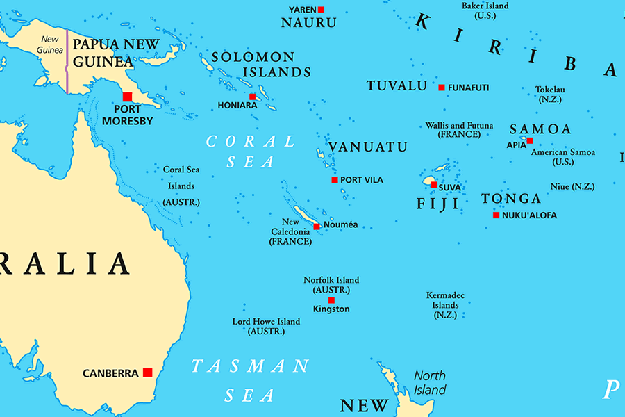
| This map shows a view of the South Pacific Ocean, the Coral Sea, and some of the island groups that surround Tuvalu. Capital city locations are shown by red squares. Map by Peter Hermes Furian and Alamy. |
Tuvalu Neighboring Island Groups:
Solomon Islands, Vanuatu, Wallis and Futuna, Fiji, Tonga, Samoa, American Samoa.Regional Maps:
New Zealand, Australia, Ocean Map, World MapTuvalu's COP26 Address Goes Viral
In November 2021, Tuvalu's foreign minister Simon Kofe addressed the United Nations Climate Change Conference (COP26) while standing at a partially submerged lectern. The lectern was placed on a spot that was once dry land, but is now below sea level. Kofe's address went viral, as it was a striking visual example of the real-life effects of sea level rise.
For some people, climate change can seem like an abstract idea, an imaginary problem, or something that can be ignored. For other people, such as the residents of Tuvalu, climate change is a very real, very serious existential threat. The people of Tuvalu see the ocean creeping closer and closer to their homes every year. They cannot ignore the imminent threat of the water lapping at their doorsteps. Additionally, these people cannot simply move to higher ground, because higher ground does not exist; the islands have a mean elevation of just 2 meters (6 feet) above sea level.
It seems very unlikely that all of the world's major polluters will have a sudden change of heart, collectively opting to prioritize our planet over their own profits. In all likelihood, the planet will continue to get hotter, glaciers and polar ice will continue to melt, and sea level will continue to rise. What can be done to save the tiny, low-lying island nations?
In November 2022, Tuvalu announced its plan to create a digital replica of their country. The idea behind this is to have a digital place where Tuvalu's cultural heritage is preserved, even after the physical islands have been swallowed by the sea.
In November 2023, Tuvalu and Australia signed the Falepili Union treaty, which will provide a pathway for Tuvaluans to migrate to Australia. Currently, Australia is prepared to accept 280 Tuvaluan climate refugees per year. However, the number of people seeking refuge is in the thousands. The recipients of these special visas will be chosen by random drawing from the application pool.
In the next few decades, the fate of Tuvalu will become clear. According to a report by NASA's Sea Level Change Team, "Much of the land area and critical infrastructure will sit below the average high tide level by 2050."
With the way things are going, this grim prediction is destined to become a reality. Tuvalu may become the first of many extinct island nations that will exist only in cyberspace and memories.
Where is Tuvalu?

Tuvalu Satellite Image

| This satellite image shows the Funafuti atoll, which serves as the capital of Tuvalu. Most of the major administrative buildings are located in the village of Vaiaku. Data for the satellite image above was acquired by NASA's Landsat 8 satellite in September 2023. Click for a larger view. |

Explore Tuvalu Using Google Earth:
Google Earth is a free program from Google that allows you to explore satellite images showing the villages and landscapes of Tuvalu and all of Oceania in fantastic detail. It works on your desktop computer, tablet, or mobile phone. The images in many areas are detailed enough that you can see houses, vehicles, and even people on a city street. Google Earth is free and easy-to-use.
Tuvalu on a World Wall Map:
Tuvalu is one of nearly 200 countries illustrated on our Blue Ocean Laminated Map of the World. This map shows a combination of political and physical features. It includes country boundaries, major cities, major mountains in shaded relief, ocean depth in blue color gradient, along with many other features. This is a great map for students, schools, offices, and anywhere that a nice map of the world is needed for education, display, or decor.Tuvalu's Islands:
Tuvalu is a low-lying island nation which consists of an archipelago of six coral atolls and three reef islands. Each of these constitutes a district of the country. From northernmost to southernmost, they are: Nanumea, Niutao, Nanumanga, Nui, Vaitupu, Nukufetau, Funafuti, Nukulaelae, and Niulakita. Over half of the population lives on Funafuti atoll.Tuvalu's Towns:
Towns in Tuvalu include Asau, Fakaifou, Fangaua, Kulia, Lolua, Niulakita, Savave, Tanrake, Tonga, and Vaiaku.Tuvalu Natural Resources:
The waters surrounding Tuvalu are plentiful with tuna and other types of fish. The country can generate revenue by allowing foreign vessels to fish in their waters. Coconut is another resource; in Tuvalu it is a dietary staple as well as a traditional building material.Tuvalu Natural Hazards:
As a low-lying island nation with a mean elevation of just 2 meters (6 feet) above sea level, the islands of Tuvalu are extremely vulnerable to rising sea levels. Several times per year, perigean spring tide events threaten to flood low-lying areas. Additionally, wind and storm surge from tropical cyclones can cause devastating damage.Tuvalu Environmental Issues:
Rising sea levels are causing noticeable beach erosion in Tuvalu. Deforestation and damage to coral reefs are also concerns for the country. Additionally, many people in Tuvalu do not have a reliable supply of potable water due to limited freshwater resources.