Geological Terms Beginning With "D"
For terms beginning with other letters, please click below
|
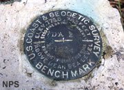
Datum
A reference location or elevation which is used as a starting point for subsequent measurements. Sea level is a datum for elevation measurements. Datums can also be arbitrary such as the starting point for stream stage measurements or based upon a physical feature such as the base of a rock unit. Shown in the photo is a "bench mark." A location of accurately measured elevation, latitude and longitude that is labeled with a carefully placed marker.
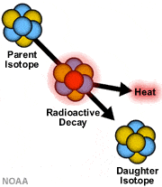
Daughter Isotope
When a radioactive isotope spontaneously decays into a new substance along with a release of heat, that new substance is known as the "daughter isotope."
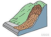
Debris Avalanche
The very sudden downslope movement of rock and soil on a steep slope. A debris avalanche differs from a debris flow mainly on the basis of its speed.
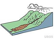
Debris Flow
A type of mass movement in which a combination of rocks, soil, organic matter, air and water flow downslope as a slurry. Debris flows differ from mud flows because they are mainly rock material instead of mud. They can be triggered by heavy precipitation, rapid snow melt or vibrations. Fires that remove vegetation often make a slope vulnerable to debris flows. Many debris flows are rapid, moving at over 60 miles per hour. Others are very slow, moving less than a few feet per year, mainly during times of rain or snow melt.
Decollment
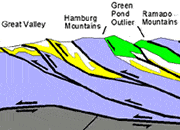
A horizontal to subhorizontal fault or shear zone. The rocks above the fault have been moved laterally relative to the rocks below the fault. This often produces a situation where the rocks above the fault have entirely different structures than the rocks below the fault. Decollments usually develop at convergent plate boundaries where compressional forces detach and move large slabs of surface rock. In the Appalachians, basal detachment faults (decollments) have produced situations where the rocks above the fault have been moved miles to the west with a style of folding and faulting that is consistent with compression. The lowest fault in the image is a decollment that underlies the New Jersey Highlands.
Deflation
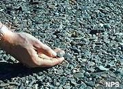
The removal of clay- and silt-size particles from a soil by wind erosion. The term can also be used in reference to the removal by wind of any unconsolidated material. The surface that remains after all unprotected fine material is removed is known as a "desert pavement."
Deformation
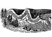
A change in the original shape of a rock unit in response to stress and strain. It can be brittle deformation that results in faulting or plastic deformation that results in folding. Image by Sir Charles Lyell.
Delay Rental
A payment to a mineral rights owner by a lessee if commercial production does not begin according to the terms of the mineral rights contract. Failure to pay the delay rental will result in termination of the lease.

Delta
A deposit of sediment that forms where a stream enters a standing body of water such as a lake or ocean. The name is derived from the Greek letter "delta" because these deposits typically have a triangular shape in map view. At a delta, streams often branch into "distributaries" that distribute their water and sediment load in multiple directions. Shown in the photo is the Nile Delta, where the Nile River enters Mediterranean Sea. The green vegetation of the well-watered delta contrasts sharply with the light brown sands of adjacent lands.
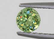
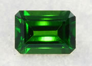
Demantoid Garnet
Demantoid is a calcium-rich garnet. It has the highest dispersion (ability to separate white light into colors of the spectrum) of any gemstone - higher than diamond. This gives demantoid an exceptional "fire."
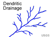
Dendritic Drainage
A stream drainage pattern that resembles the branching of a tree in map view. Occurs mainly where the rocks below are horizontal and have a uniform resistance to erosion. It can also develop above crystalline igneous rocks that are uniform in their resistance to erosion.
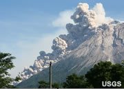
Density Current
A gravity-driven flow of a dense fluid down a slope through a fluid of lower density. They occur on land (pyroclastic flows) or underwater (turbidity currents). Density currents often occur underwater where the fluids have differences in temperature, salinity, or concentration of suspended particles. The image shows a pyroclastic flow descending down the south flank of Merapi Volcano (Indonesia) in 2006.
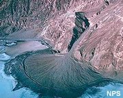
Deposition
The settling from suspension of transported sediments. Also, the precipitation of chemical sediments from mineral-rich waters. Shown in the photo is the Badwater Alluvial Fan of Death Valley, where sediments are deposited as a stream, flowing down a steep slope, encounters the flat surface of the valley and loses energy, dropping its sediment load.

Desert Pavement
A ground cover of granule-size and larger particles that is typically found in arid areas. This ground cover of coarse particles is a residual deposit - formed when the wind selectively removes the sand-, silt- and clay-sized materials. The persistent action of wind will eventually remove all of the small particles leaving a rocky surface known as a "desert pavement."
Desert Varnish
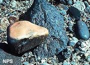
A thin coating of dark material, often iron or manganese oxides, that forms on the surface of rocks and pebbles exposed at Earth's surface in a desert region. If these rocks are picked up and turned over, the bottoms of the rocks often do not have this coating (as shown by one rock in the photo that has been turned over). The rate of development varies from one location to another depending upon conditions.
Desiccation Cracks
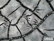
A network of polygonal shrinkage cracks that open in mud as the water within is slowly evaporated. They can harden, and if buried, can be lithified as a preserved sediment surface that is evidence of submersion followed by subaerial exposure. They can indicate a sedimentary environment of a lake shore, river bank or low-energy beach. Also known as mud cracks.
Detrital
A word used in reference to sediments or sedimentary rocks that are composed of particles that were transported and deposited by wind, water or ice.
Development
The work done on a mineral property before mineral production begins on a commercial scale.
Development Well
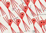
A well drilled within the proven area of an oil or gas reservoir to the depth of the productive stratigraphic horizon. These wells are expected to be productive. Shown in the image are horizontal legs of development wells in the Utica Shale of eastern Ohio.
Developmental Drilling
Drilling done to delineate the boundaries of a known mineral deposit or to evaluate the deposit in advance of production.
Diagenesis
All of the changes which happen to a sediment after deposition, excluding weathering and metamorphism. Diagenesis includes compaction, cementation, leaching and replacement.

Diamond
The most popular gemstone and hardest natural material. A nearly colorless diamond is set in most engagement rings sold in the United States. The custom of giving an engagement diamond is spreading to other countries.
Diatom
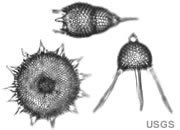
A one-celled plant that lives in the shallow waters of lakes, streams or oceans. Many of these secrete a shell or internal parts composed of silica. Diatoms can occur in very large numbers and can make significant contributions to sea-floor or lake sediment.
Diatomaceous Earth
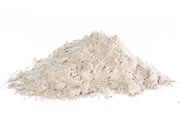
A white to light colored powder that is produced by crushing the sedimentary rock known as "diatomite." Diatomaceous earth has commercial use as a filter medium; a cement additive; a fill and extender in paint, rubber and plastics; an absorbent, a mild abrasive, a drying agent and numerous other uses. Image copyright iStockphoto / MonaMakela.
Diatomite
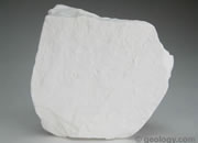
A light-colored, fine-grained siliceous sedimentary rock that forms from a sediment rich in the siliceous remains of diatoms. It is very porous, sometimes porous enough that it can temporarily float on water. Diatomite is usually marine but can be lacustrine. When crushed into a powder it is known as "diatomaceous earth" or "DE" which has many industrial uses.
Diatom Ooze
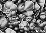
A siliceous seafloor sediment that consists of at least 30% diatom remains.

Differentiated Planet
A planet that has layers composed of materials with different densities and different properties. As an example, Earth is a differentiated planet because it has a metal-rich core, surrounded by a rocky mantle, and covered by a crust of low-density minerals.
Dike
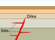
A subsurface igneous rock body that is tabular in shape and cuts across the bedding or foliation of the older rock through which it has intruded.
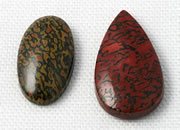
Dinosaur Bone
Dinosaur bone is often petrified (fossilized by being infilled and replaced by quartz). The quartz can be very colorful. When the petrification is thorough, the material can be cut and polished into attractive gems.
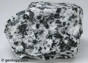
Diorite
A coarse-grained, intrusive igneous rock that contains a mixture of feldspar, pyroxene, hornblende and sometimes quartz.
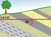
Dip
The angle that a rock unit, fault or other rock structure makes with a horizontal plane. Expressed as the angular difference between the horizontal plane and the structure. The angle is measured in a plane perpendicular to the strike of the rock structure. The rock units in the image dip to the right at 30 degrees.
Directional Drilling
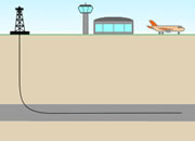
Drilling wells that are deliberately deviated from the vertical to hit a target that is not directly beneath the well site or to penetrate a greater thickness of rock within a productive zone.
Discharge
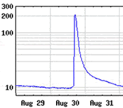
The volume of water in a flowing stream that passes a given location in a unit of time. Frequently expressed in cubic feet per second or cubic meters per second. Calculated by the formula Q = A x V - where Q is the discharge, A is the cross sectional area of the channel and V is the average velocity of the stream. The hydrograph at left shows a peak discharge of a little over 200 cubic feet per second.

Discharge Area
A geographic location where groundwater naturally emerges onto Earth's surface or into a body of surface water such as a swamp, river, lake, sea or ocean.
Discontinuity
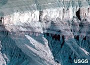
The word "discontinuity" has multiple meanings in geology. In sedimentary geology, a discontinuity is a break in sedimentation that produces a time gap in the sediment record. In seismic science, a discontinuity is a surface (such as the boundary between rock units) where seismic waves abruptly change velocity. In structural geology, a discontinuity is a surface separating unrelated rock units such as a fault. The photo is an image of "The Great Unconformity" of the Grand Canyon. It is an erosional surface and a gap in geologic time. It separates horizontal rocks of the younger Tonto Group from the steeply dipping rocks of the much older Grand Canyon Supergroup.
Displacement
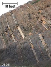
The word used for the relative movement of the two blocks of a fault. It is usually given in units of linear measure such as feet or meters. When observed in outcrop or on Earth's surface, the amount of displacement measured is apparent because motion in directions other than parallel to the face of the outcrop or Earth's surface cannot be assessed. The apparent displacement on the fault shown in the photo is about ten feet. It is a small fault exposed in an outcrop in San Mateo County, California.
Dissolved Load
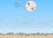
Dissolved ions being carried by a stream. There are three basic components to a stream's load: 1) bedload that rests on the bottom of the stream, only to be moved during times of high flow; 2) suspended load held above the bottom when current velocities are high enough to lift and hold the material in suspension; and, 3) dissolved ions carried in solution, represented by the red "+" and "-" signs in the image at left.
Distribution Pipeline
A pipeline that carries natural gas between a main transmission line and a consumer.
|
Dictionary of Geological Terms - Only $19.99 All scientific disciplines have an essential vocabulary that students and professionals must understand to learn and communicate effectively. A geology dictionary that is used regularly is one of the most important tools for developing professional competence. A good dictionary should be on the desk of every geologist and within easy reach. This dictionary is compact and inexpensive at only $19.99. More information. |
Divergent Boundary
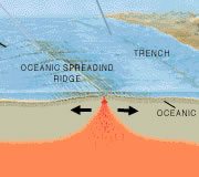
A boundary between two lithospheric plates that are pulling away from one another. These are structural environments of regional extension with normal faulting. The mid ocean ridges are located above convection currents that work to create extensional stress that can produce a divergent boundary.
Divide
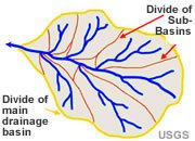
A ridge or other topographic feature that separates two adjacent drainage basins. It is an imaginary line that separates two different directions of surface water flow.
Dome
An uplift that is round or elliptical in map view with beds dipping away in all directions from a central point.
Domestic Operations
Domestic operations are activities located in the United States, including the offshore territorial waters, U.S. commonwealth territories, and protectorates.

Dowsing
The practice of locating groundwater by walking the surface of a property holding a forked stick, a pair of L-shaped rods, a pendulum or another tool that responds when the person moves above a location that will yield an adequate flow of water to a drilled well. Although many people believe in this practice, including a few geologists, it is almost unanimously rejected by geologists and hydrologists. The National Ground Water Association has issued a position statement that rejects the practice. Also known as "water witching," "divining" and "doodlebugging." Image copyright iStockphoto / Monika Wisniewska.
Drainage Basin
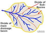
The geographic area that contributes runoff to a stream. It can be outlined on a topographic map by tracing the points of highest elevation (usually ridge crests) between two adjacent stream valleys. Also referred to as a "watershed."
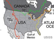
Drainage Divide
The boundary between two adjacent drainage basins. Drainage divides are ridge crests (or less obvious locations where slope of the landscape changes direction). Runoff produced on one side of the ridge flows into stream "A" and runoff on the other side of the ridge flows into stream "B". The image shows the continental drainage divides of the United States.
Drawdown
A lowering of the water table around a producing well. The drawdown at any given location will be the vertical change between the original water table and the level of the water table reduced by pumping.
Drift
A general term for all sedimentary materials deposited directly from the ice or melt water of a glacier.
Drilling Arrangement
A contractual agreement under which a mineral rights owner or lessee assigns a fractional interest in a property to another party. This assignment might be done for financial support of exploration and development. It could also be done in exchange for the recipient doing the development work on that property.
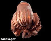
Drill Bit
A cutting tool attached to the drill pipe and used to bore a well into bedrock. The drill pipe turns the drill bit and tiny particles of diamond embedded in the edges of the drill bit grind their way through the rock. The drill bit is cooled by drilling mud that is pumped down the drill pipe and circulates back up to the surface between the wall of the well and the drill pipe. The circulation of the drilling mud also removes cuttings that would otherwise clog the well bore.
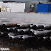
Drill Pipe
Seamless steel tubing used in the drilling of oil and gas wells. The drill pipe rotates the bit. Drilling fluid is pumped down the pipe, exits through the bit and flows up the space between the pipe and the wall of the well, delivering cuttings to the surface. Sections of drilling pipe are generally 30 feet in length and couple together will tool joints.
Drumlin
A low, smoothly rounded, elongate hill. Drumlins are deposits of compacted till that are sculpted beneath the ice of a flowing glacier. The long axis of a drumlin parallels the flow direction of the ice.

Dry Hole
A well drilled in hopes of finding oil or natural gas that fails to yield commercial production rates. The image is the map symbol for a dry hole.

Dry-Hole Contribution
A payment made to the owner of an unsuccessful well in exchange for a log of the well and evaluation data. The image is the map symbol for a dry hole.
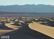
Dune
A mound or ridge of wind-blown sand. Typically found in deserts or inland from a beach. Most dunes slowly move in a down-wind direction as sand is blown up the windward side of the dune, moves over the crest and tumbles down the leeward side.
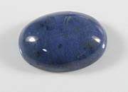
Dumortierite
Dumortierite is a dark blue to dark greenish-blue silicate mineral with a chemical composition of Al7BO3(SiO4)3O3 found in metamorphic rocks. It is typically opaque and when attractive can be used to produce cabochons, beads and tumbled stones.
|
| More General Geology |
 |
Diamonds from Coal? |
 |
What is a Geyser? |
 |
What is the San Andreas Fault? |
 |
Igneous and Volcanic Features |
 |
The Doorway to Hell |
 |
Topo Maps |
 |
Geology Dictionary |
 |
Gifts That Rock |

Find Other Topics on Geology.com:

|

| ||
|

| ||

|

| ||
|

|

