Hurricane Melissa Leaves Dozens Dead and Destruction Across Cuba, Haiti and Jamaica
Associated Press (article link) / ABC News (video)
Link to the story is at Associated Press, Video is by ABC News
Associated Press (article link) / ABC News (video)
Link to the story is at Associated Press, Video is by ABC News
Residents of France’s Last Outpost in North America Try to Outrun the Sea
The Guardian
From the article: "As rising tides eat away at the Saint-Pierre and Miquelon archipelago off the island of Newfoundland, Canada, plans to move the historic village to higher ground have divided residents.
The Guardian
From the article: "As rising tides eat away at the Saint-Pierre and Miquelon archipelago off the island of Newfoundland, Canada, plans to move the historic village to higher ground have divided residents.
Qatar
United States Energy Information Administration

Although Qatar is a tiny country, it has enormous oil and natural gas resources, ranking 12th worldwide in the amount of energy produced on a BTU basis.
United States Energy Information Administration

Although Qatar is a tiny country, it has enormous oil and natural gas resources, ranking 12th worldwide in the amount of energy produced on a BTU basis.
California Sees a Return of "Gold Fever" Amid Record High Gold Prices
San Francisco Chronicle

Photograph of a person panning for gold with a metal pan in Bonanza Creek near Dawson, Yukon, Canada. A Wikimedia image attributed to Janothird and displayed here under a GNU Free Documentation License.
San Francisco Chronicle

Photograph of a person panning for gold with a metal pan in Bonanza Creek near Dawson, Yukon, Canada. A Wikimedia image attributed to Janothird and displayed here under a GNU Free Documentation License.
The Many Uses of Gold
Geology.com
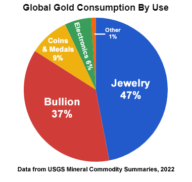
The United States government currently mints coins from gold and other precious metals; however, they are intended for investment and collecting. They are not intended for use as legal tender.
Geology.com

The United States government currently mints coins from gold and other precious metals; however, they are intended for investment and collecting. They are not intended for use as legal tender.
Antarctic Krill: How Did a Paperclip-sized Crustacean Cause a Diplomatic Row ?
and... Why Are Krill So Important in the Southern Ocean ?
The Guardian

Antarctic krill feed on plankton and are an important creature in the food chain of the Southern Ocean. They also serve as a store of carbon and help regulate the level of carbon in Earth's atmosphere.
The image shows an Antarctic krill with a spitball in the lower right corner and a fecal string in the lower left corner. The photo is attributed to Uwe Kils and is displayed here under a GNU Free Document License.
and... Why Are Krill So Important in the Southern Ocean ?
The Guardian

Antarctic krill feed on plankton and are an important creature in the food chain of the Southern Ocean. They also serve as a store of carbon and help regulate the level of carbon in Earth's atmosphere.
The image shows an Antarctic krill with a spitball in the lower right corner and a fecal string in the lower left corner. The photo is attributed to Uwe Kils and is displayed here under a GNU Free Document License.
Map of the World's Oceans
Geology.com

Although there is only one global ocean, geographers have divided it into five major regions (which are also called "oceans"). They are: the Atlantic Ocean, the Pacific Ocean, the Indian Ocean, the Arctic Ocean and the Southern Ocean. These names facilitate communication. People who wish to be more specific can use names such as "the North Atlantic Ocean".
Geology.com

Although there is only one global ocean, geographers have divided it into five major regions (which are also called "oceans"). They are: the Atlantic Ocean, the Pacific Ocean, the Indian Ocean, the Arctic Ocean and the Southern Ocean. These names facilitate communication. People who wish to be more specific can use names such as "the North Atlantic Ocean".
Hurricane Melissa Could Be Jamaica's Most Powerful Storm in History
NBC News

Click the map above to see the latest information for this storm on the National Hurricane Center website.
NBC News

Click the map above to see the latest information for this storm on the National Hurricane Center website.
Interactive Atlas of Critial Minerals
United States Geological Survey

Critical minerals power the technology behind smartphones, computers and even fighter planes. The interactive Critical Minerals Atlas shows where these critical minerals are produced around the world. At this website you can click on a country to see how many critical minerals it produces, its share of global production, and how each mineral is used.
United States Geological Survey

Critical minerals power the technology behind smartphones, computers and even fighter planes. The interactive Critical Minerals Atlas shows where these critical minerals are produced around the world. At this website you can click on a country to see how many critical minerals it produces, its share of global production, and how each mineral is used.
Why Is This Remote and Rugged River in Alaska Turning Orange?
Smithsonian Magazine
Author John McPhee described the Salmon River as having "the clearest, purest water I have ever seen flowing over rocks." Today, oxidizing minerals in thawing permafrost have given the river an orange "rusty" color.
Smithsonian Magazine
Author John McPhee described the Salmon River as having "the clearest, purest water I have ever seen flowing over rocks." Today, oxidizing minerals in thawing permafrost have given the river an orange "rusty" color.
Archaeologists Uncover the Oldest Known Projectile Points in the Americas
(This item is not "News" but it is interesting and related to the item below.)
Phys.org
Oregon State University archaeologists have uncovered projectile points in Idaho that are thousands of years older than any previously found in the Americas, helping to fill in the history of how early humans crafted and used stone weapons.
New Artifacts Suggest People Arrived in North America Earlier than Previously Thought
Phys.org
Stone tools and other artifacts unearthed from an archeological dig at the Cooper's Ferry site in western Idaho suggest that people lived in the area 16,000 years ago, more than a thousand years earlier than scientists previously thought.
Phys.org
Stone tools and other artifacts unearthed from an archeological dig at the Cooper's Ferry site in western Idaho suggest that people lived in the area 16,000 years ago, more than a thousand years earlier than scientists previously thought.
NOAA's Flood Inundation Mapping Tool Expands to Cover 60% of the U.S. Population
National Oceanic and Atmospheric Administration

From the article: "NOAA announced that the groundbreaking experimental Flood Inundation Mapping tool has expanded significantly to serve 60% of the U.S. population, up from 30% the previous year. The tool provides near-real-time, high-resolution, street-level visualizations of flood waters to assist National Weather Service forecasters in issuing flood watches and flood warnings." The simulated image shown above shows potential flooding over Warfield, Kentucky, along the Tug Fork River in February 2025.
National Oceanic and Atmospheric Administration

From the article: "NOAA announced that the groundbreaking experimental Flood Inundation Mapping tool has expanded significantly to serve 60% of the U.S. population, up from 30% the previous year. The tool provides near-real-time, high-resolution, street-level visualizations of flood waters to assist National Weather Service forecasters in issuing flood watches and flood warnings." The simulated image shown above shows potential flooding over Warfield, Kentucky, along the Tug Fork River in February 2025.
Landsat at Work: USGS Informing Domestic Lithium Development
United States Geological Survey

From the USGS article: "Landsat data can be used to estimate groundwater depth and assess vegetation near potential mine sites, which are two key factors in environmental impact assessments. A recent example of this application is the Thacker Pass project in Northern Nevada’s Humboldt County, where lithium is plentiful but water is scarce."
Mine location image from Google Maps. Google maps also serves as an information source for many mineral assessment and development projects.
United States Geological Survey

From the USGS article: "Landsat data can be used to estimate groundwater depth and assess vegetation near potential mine sites, which are two key factors in environmental impact assessments. A recent example of this application is the Thacker Pass project in Northern Nevada’s Humboldt County, where lithium is plentiful but water is scarce."
Mine location image from Google Maps. Google maps also serves as an information source for many mineral assessment and development projects.
USGS Supports 13 States in Joint Work on Critical Minerals in Mine Waste
United States Geological Survey

Photograph of USGS staff members atop a stockpile of waste rock at a mine in New Mexico.
United States Geological Survey

Photograph of USGS staff members atop a stockpile of waste rock at a mine in New Mexico.
Australian Rainforests Become the First to Emit More Carbon Than They Absorb
Smithsonian Magazine

Photograph of the Daintree Rainforest, Queensland, Australia by Robert Linsdell, displayed here under a Creative Commons License.
Smithsonian Magazine

Photograph of the Daintree Rainforest, Queensland, Australia by Robert Linsdell, displayed here under a Creative Commons License.
What Happened to Pompeii Residents Who Survived the AD 79 Eruption of Vesuvius?
Live Science
Quote from the article: "I have found two or three rich guys, but I found a couple hundred middle class and even some desperately poor people who made it out and left records. And that shocked me."
Live Science
Quote from the article: "I have found two or three rich guys, but I found a couple hundred middle class and even some desperately poor people who made it out and left records. And that shocked me."
Mount Vesuvius: The Volcano that Buried Pompeii
Geology.com
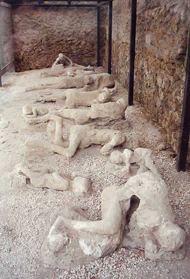
Plaster casts of people who died in the city of Pompeii during the 79 AD eruption of Mount Vesuvius. They were buried in volcanic ash. Image: Garden of the Fugitives. This photo was taken by Lancevortex and is distributed under a GNU Free Documentation License.
Geology.com

Plaster casts of people who died in the city of Pompeii during the 79 AD eruption of Mount Vesuvius. They were buried in volcanic ash. Image: Garden of the Fugitives. This photo was taken by Lancevortex and is distributed under a GNU Free Documentation License.
U.S. Natural Gas Exports to Mexico Reach New Records
Energy Information Administration

Natural gas exports from the United States to Mexico have been rising, reaching record levels in 2025.
Energy Information Administration

Natural gas exports from the United States to Mexico have been rising, reaching record levels in 2025.
Fisherman Was Digging for Worms When He Stumbled Upon a Trove of Medieval Silver
Smithsonian Magazine
A fisherman who was digging for worms near Stockholm, Sweden found a fantastic surprise: a copper cauldron full of silver jewelry and coins. The cache, which weighs a whopping 13 pounds (5.89 kg), is thought to date back to the twelfth century.
Smithsonian Magazine
A fisherman who was digging for worms near Stockholm, Sweden found a fantastic surprise: a copper cauldron full of silver jewelry and coins. The cache, which weighs a whopping 13 pounds (5.89 kg), is thought to date back to the twelfth century.
The Many Uses of Silver
Geology.com

When most people hear the word "silver", they probably think of jewelry and coins. However, silver has unique properties that make it very useful for many different industrial applications. Images copyright iStockphoto / Jorge Farres Sanchez, Tatiana Buzuleac, Nigel Spooner, and Stephanie Frey.
Geology.com

When most people hear the word "silver", they probably think of jewelry and coins. However, silver has unique properties that make it very useful for many different industrial applications. Images copyright iStockphoto / Jorge Farres Sanchez, Tatiana Buzuleac, Nigel Spooner, and Stephanie Frey.
What You Might Not Know About the Manicouagan Crater
United States Geological Survey on YouTube
From the video description: "In the late Triassic Period, a 3 mile wide asteroid struck northern Pangea at over 30,000 miles per hour. The resulting crater is now 214 million years old, but the dramatic circular lake visible in 2024 Landsat imagery is a surprisingly recent feature."
Celebrating the Tercentenary of James Hutton (1726–1797), The Founder of Modern Geology
Speaking of Geoscience

From Wikipedia: "Hutton was a Scottish geologist, agriculturalist, chemical manufacturer, naturalist and physician. He is often referred to as the 'Father of Modern Geology,' because he played a key role in establishing geology as a modern science." Photo of Siccar Point, the outcrop that helped Hutton realize the enormous extent of Geologic Time, by Stuart Sutherland.
Speaking of Geoscience

From Wikipedia: "Hutton was a Scottish geologist, agriculturalist, chemical manufacturer, naturalist and physician. He is often referred to as the 'Father of Modern Geology,' because he played a key role in establishing geology as a modern science." Photo of Siccar Point, the outcrop that helped Hutton realize the enormous extent of Geologic Time, by Stuart Sutherland.
Oil and Natural Gas In the Eastern Mediterranean Region
Energy Information Administration

This brief examines the regional dynamics of the oil and natural gas markets in the Eastern Mediterranean, focusing on Israel, Egypt, Cyprus, Jordan, and Lebanon. Map by the Energy Information Administration.
Energy Information Administration

This brief examines the regional dynamics of the oil and natural gas markets in the Eastern Mediterranean, focusing on Israel, Egypt, Cyprus, Jordan, and Lebanon. Map by the Energy Information Administration.
North America's LNG Export Capacity Could More Than Double by 2029
Energy Information Administration

Liquefied natural gas exporters in the United States plan to more than double their liquefaction capacity by adding an estimated 13.9 billion cubic feet per day between 2025 and 2029.
Energy Information Administration

Liquefied natural gas exporters in the United States plan to more than double their liquefaction capacity by adding an estimated 13.9 billion cubic feet per day between 2025 and 2029.
What is LNG - Liquefied Natural Gas?
Geology.com

An LNG carrier ship docked at the Bontang LNG liquefaction terminal in East Kalimantan, Indonesia. The LNG is carried in the ship's four dome-shaped tanks. Image copyright iStockphoto / Mayumi Terao.
Geology.com

An LNG carrier ship docked at the Bontang LNG liquefaction terminal in East Kalimantan, Indonesia. The LNG is carried in the ship's four dome-shaped tanks. Image copyright iStockphoto / Mayumi Terao.
How China's Rare Earth Restrictions Could Disrupt the U.S.
Defense Industry and Reignite a Trade War
CNBC
Quote from the article: "China will not allow the export of rare earth materials for use by foreign militaries under restrictions announced last week."
Defense Industry and Reignite a Trade War
CNBC
Quote from the article: "China will not allow the export of rare earth materials for use by foreign militaries under restrictions announced last week."
Did You Know that Some Microscopic Organisms Are Able to Move Through Polar Ice?
EOS
From the article: "New research has shown that ice diatoms have adapted to move efficiently through the ice, allowing them to navigate to better sources of light and nutrients."
EOS
From the article: "New research has shown that ice diatoms have adapted to move efficiently through the ice, allowing them to navigate to better sources of light and nutrients."
Evidence of Partial Synchronization of the San Andreas Fault and Cascadia Megathrust
Geosphere

A new study suggests that an enormous earthquake in the Cascadia Subduction Zone could trigger a major earthquake in California. Public domain image by the United States Geological Survey.
Geosphere

A new study suggests that an enormous earthquake in the Cascadia Subduction Zone could trigger a major earthquake in California. Public domain image by the United States Geological Survey.
New Maps of Natural Radioactivity Reveal Critical Minerals and More
EOS

From the article: "High-resolution airborne radiometric surveys are covering more ground than ever to provide insights into unseen geology, mineral resource potential, and possible health hazards."
About the photo: "An airborne radiometric survey helicopter used to collect radiometric and magnetic data during low altitude flights over Maryland, Pennsylvania, and West Virginia in 2022." Public domain image by Anjana Shah, U.S. Geological Survey.
EOS

From the article: "High-resolution airborne radiometric surveys are covering more ground than ever to provide insights into unseen geology, mineral resource potential, and possible health hazards."
About the photo: "An airborne radiometric survey helicopter used to collect radiometric and magnetic data during low altitude flights over Maryland, Pennsylvania, and West Virginia in 2022." Public domain image by Anjana Shah, U.S. Geological Survey.
Non-Stop Snow, Instant Noodles, and Yaks: Trekkers Trapped on Everest
The Guardian
Did you see TV news about "1,000 people trapped on Mount Everest?" Many of these people were not climbing to the summit. Instead they were on a multi-day trek (hike) and got caught in the bitter weather of a severe mountain snow storm. Many sheltered for days in their tents - until rescued by local villagers, yak herders, and mountain guides. More of this embarrassing story in The Guardian's article.
Two Powerful Earthquakes Strike the Philippines With Numerous People Killed
ABC News

A strong 7.4 magnitude earthquake occurred off the southeastern part of the Philippines archipelago. It produced intensity 7 shaking in Davao City and was felt by millions of people across the Philippines islands. Numerous aftershocks are being felt.
ABC News

A strong 7.4 magnitude earthquake occurred off the southeastern part of the Philippines archipelago. It produced intensity 7 shaking in Davao City and was felt by millions of people across the Philippines islands. Numerous aftershocks are being felt.
Rare Earth Stocks Surge After China Tightens Exports (article and video)
CNBC
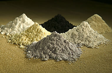
China tightens their exports of rare earth minerals, and shares of U.S. rare earth and critical mineral miners / processors shot up in price. The Trump administration has taken equity stakes in several companies to assist them in developing domestic sources, processing, and manufacturing capabilities for these materials.
CNBC

China tightens their exports of rare earth minerals, and shares of U.S. rare earth and critical mineral miners / processors shot up in price. The Trump administration has taken equity stakes in several companies to assist them in developing domestic sources, processing, and manufacturing capabilities for these materials.
Rare Earth Element Production is Up... China Is Still the Big Producer
Geology.com

This chart shows a history of rare earth element production, in metric tons of rare earth oxide equivalent, between 1955 and 2024. It clearly shows the United States' entry into the market in the mid-1960s when color television exploded demand. When China began selling rare earths at very low prices in the late 1980s and early 1990s, mines in the United States were forced to close because... read the full caption and article.
Geology.com

This chart shows a history of rare earth element production, in metric tons of rare earth oxide equivalent, between 1955 and 2024. It clearly shows the United States' entry into the market in the mid-1960s when color television exploded demand. When China began selling rare earths at very low prices in the late 1980s and early 1990s, mines in the United States were forced to close because... read the full caption and article.
Get an Eyeful of Iceland in 20 Photos That Capture Its Natural Beauty
Smithsonian Magazine

Iceland is an island in the North Atlantic Ocean, located between Greenland, Norway and the UK. These spectacular photos include the following: Icelandic volcanoes, the Northern Lights, aerial views of the Icelandic Highlands, a view of the black sand beach to the snow-covered mountain named Vestrahorn, the braided and ice-covered Tungnaa River, a colorful puffin, the hotspot responsible for Fagradalsfjall Volcano, Icelandic horses, waterfalls, wildlife, a cave under a glacier, a hot spring, red-hot lava flows, winter beaches, Svortuloft Lighthouse, a red crater, black sand, and green mountains.
Smithsonian Magazine

Iceland is an island in the North Atlantic Ocean, located between Greenland, Norway and the UK. These spectacular photos include the following: Icelandic volcanoes, the Northern Lights, aerial views of the Icelandic Highlands, a view of the black sand beach to the snow-covered mountain named Vestrahorn, the braided and ice-covered Tungnaa River, a colorful puffin, the hotspot responsible for Fagradalsfjall Volcano, Icelandic horses, waterfalls, wildlife, a cave under a glacier, a hot spring, red-hot lava flows, winter beaches, Svortuloft Lighthouse, a red crater, black sand, and green mountains.
Electricity is Becoming More Common for Residential Heating
Energy Information Administration

Since 2010 the percentage of homes being heated by electricity has risen from 35% to 42%. At the same time the number being heated by heating oil or wood has gone down, and the number heated by propane or other fuels has remained approximately the same.
Energy Information Administration

Since 2010 the percentage of homes being heated by electricity has risen from 35% to 42%. At the same time the number being heated by heating oil or wood has gone down, and the number heated by propane or other fuels has remained approximately the same.
By 2100, Humans Might See a Glacier-Free Sierra Nevada for the First Time Ever
Smithsonian Magazine
New research suggests that within the next 75 years, California glaciers that are thousands of years old could melt completely.
Smithsonian Magazine
New research suggests that within the next 75 years, California glaciers that are thousands of years old could melt completely.
Decades-Old Data From Saturn's Moon Enceladus Hints at Favorable Conditions for Life
Smithsonian Magazine
From the article: "The Cassini spacecraft flew by the small, icy moon in 2008, collecting information that suggests it shoots out molecules that could enable life".
Smithsonian Magazine
From the article: "The Cassini spacecraft flew by the small, icy moon in 2008, collecting information that suggests it shoots out molecules that could enable life".
Active Volcanoes of Our Solar System
Geology.com
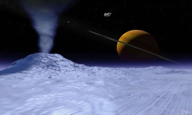
Evidence of past volcanic activity has been found on most planets in our solar system and on many of their moons. The image above is an artist's vision of what a cryovolcano might look like on the surface of Enceladus, with Saturn visible in the background. NASA image.
Geology.com

Evidence of past volcanic activity has been found on most planets in our solar system and on many of their moons. The image above is an artist's vision of what a cryovolcano might look like on the surface of Enceladus, with Saturn visible in the background. NASA image.
Imelda and Humberto Crowd the Atlantic
NASA Earth Observatory

The satellite image above shows Tropical Storm Imelda on the U.S. East Coast, with Hurricane Humberto in the Atlantic Ocean to the right. Thanks to a seldom-seen phenomenon known as the Fujiwhara Effect, Humberto's great strength pulled Imelda away from the coast and sent it eastward into the Atlantic. NASA Earth Observatory image by Lauren Dauphin, using VIIRS data from NASA EOSDIS LANCE, GIBS/Worldview, and the Suomi National Polar-orbiting Partnership.
NASA Earth Observatory

The satellite image above shows Tropical Storm Imelda on the U.S. East Coast, with Hurricane Humberto in the Atlantic Ocean to the right. Thanks to a seldom-seen phenomenon known as the Fujiwhara Effect, Humberto's great strength pulled Imelda away from the coast and sent it eastward into the Atlantic. NASA Earth Observatory image by Lauren Dauphin, using VIIRS data from NASA EOSDIS LANCE, GIBS/Worldview, and the Suomi National Polar-orbiting Partnership.
How Are Hurricanes Named?
Geology.com
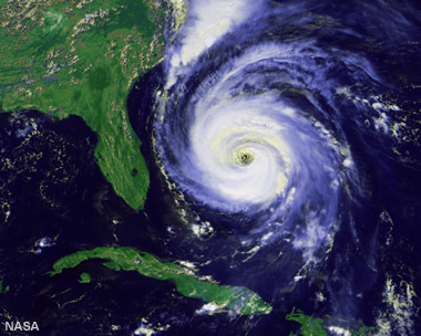
Hurricane Fran: Satellite image of a hurricane named "Fran." Hurricane Fran was a large, powerful, destructive hurricane that made landfall near Cape Fear, North Carolina on September 5, 1996. Fran was the sixth named storm of the 1996 hurricane season because "F" is the sixth letter in the alphabet. It was so destructive that the name "Fran" was retired from use. Satellite image by NASA.
Geology.com

Hurricane Fran: Satellite image of a hurricane named "Fran." Hurricane Fran was a large, powerful, destructive hurricane that made landfall near Cape Fear, North Carolina on September 5, 1996. Fran was the sixth named storm of the 1996 hurricane season because "F" is the sixth letter in the alphabet. It was so destructive that the name "Fran" was retired from use. Satellite image by NASA.
Birthstones for the Month of October: Opal and Tourmaline
Geology.com
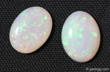
Opal is a traditional birthstone for the month of October.
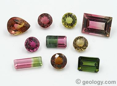
Tourmaline was added as an alternative October birthstone in 1952.
Geology.com

Opal is a traditional birthstone for the month of October.

Tourmaline was added as an alternative October birthstone in 1952.
Could a Cascadia Megathrust Earthquake Trigger the San Andreas Fault?
Speaking of Geoscience Blog

A new study suggests that an enormous earthquake in the Cascadia Subduction Zone could trigger a major earthquake in California. Public domain image by the United States Geological Survey.
Speaking of Geoscience Blog

A new study suggests that an enormous earthquake in the Cascadia Subduction Zone could trigger a major earthquake in California. Public domain image by the United States Geological Survey.
Earthquake Hazards in the Pacific Northwest
United States Geological Survey

Potential hazards of the Cascadia Subduction Zone – earthquakes, tsunamis, landslides, site amplification, turbidites, land-level change, and episodic tremor and slip. Image by the United States Geological Survey.
United States Geological Survey

Potential hazards of the Cascadia Subduction Zone – earthquakes, tsunamis, landslides, site amplification, turbidites, land-level change, and episodic tremor and slip. Image by the United States Geological Survey.
California Earthquake Maps
Geology.com
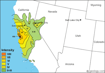
A collection of maps showing the geographic distribution of ground shaking for 12 major California earthquakes.
Geology.com

A collection of maps showing the geographic distribution of ground shaking for 12 major California earthquakes.
The Environmental Impact of AI Data Centers
Smithsonian Magazine
From the article: "The demand for data centers is growing faster than our ability to mitigate their skyrocketing economic and environmental costs".
Smithsonian Magazine
From the article: "The demand for data centers is growing faster than our ability to mitigate their skyrocketing economic and environmental costs".
The Sound of Earth's Flipping Magnetic Field
Science Alert

Artist's impression of Earth's magnetosphere produced by the interaction between the Earth's geomagnetic field and the solar winds. Image from NASA's Scientific Visualization Studio.
Science Alert

Artist's impression of Earth's magnetosphere produced by the interaction between the Earth's geomagnetic field and the solar winds. Image from NASA's Scientific Visualization Studio.
Super Typhoon Ragasa Steers Toward China
NASA Earth Observatory

In the satellite image above, the super typhoon heads for Guangdong province after lashing Taiwan and northern Luzon in the Philippines. NASA Earth Observatory image by Wanmei Liang, using MODIS data from NASA EOSDIS LANCE and GIBS/Worldview.
NASA Earth Observatory

In the satellite image above, the super typhoon heads for Guangdong province after lashing Taiwan and northern Luzon in the Philippines. NASA Earth Observatory image by Wanmei Liang, using MODIS data from NASA EOSDIS LANCE and GIBS/Worldview.
The World's Largest Rough Diamond
Geology.com
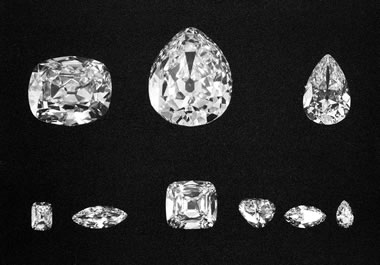
The largest rough diamond ever found was the "Cullinan Diamond" -- a 3106.75-carat stone found at the Premier Mine, near the town of Cullinan, Transvaal Colony, South Africa. The photo above shows the nine major stones cut from the Cullinan rough diamond. Together these nine stones weigh a total of 1055.89 carats. The photograph was taken in 1908 by an unknown photographer.
Geology.com

The largest rough diamond ever found was the "Cullinan Diamond" -- a 3106.75-carat stone found at the Premier Mine, near the town of Cullinan, Transvaal Colony, South Africa. The photo above shows the nine major stones cut from the Cullinan rough diamond. Together these nine stones weigh a total of 1055.89 carats. The photograph was taken in 1908 by an unknown photographer.
Gold Price Hits $3,800, as It Barrels Toward $4,000
JCK Online
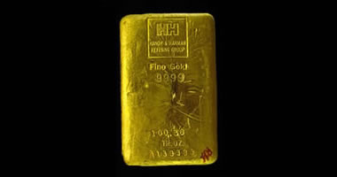
The price of gold hit $3,800 on September 25th, and today (September 29th) it is trading at $3,829 an ounce. About the image: Fine gold metal is usually cast into small bars for easy handling, exchange, and storage. USDOJ Image.
JCK Online

The price of gold hit $3,800 on September 25th, and today (September 29th) it is trading at $3,829 an ounce. About the image: Fine gold metal is usually cast into small bars for easy handling, exchange, and storage. USDOJ Image.
The Many Uses of Gold
Geology.com

The most important consumptive use of gold in the world and in the United States is jewelry manufacturing. Approximately half of all gold mined is used in jewelry. Image copyright iStockphoto / Angelo Marcantonio.
Geology.com

The most important consumptive use of gold in the world and in the United States is jewelry manufacturing. Approximately half of all gold mined is used in jewelry. Image copyright iStockphoto / Angelo Marcantonio.
'A Gift From Heaven': The TikTok Traders of Mauritania's Meteorites
The Guardian
Some people in Mauritania hunt for meteorites, hoping to find valuable specimens to sell online. The Sahara desert has become a popular hunting ground because the dark meteorites are easy to spot in the sand, and the arid climate helps to preserve their condition.
The Guardian
Some people in Mauritania hunt for meteorites, hoping to find valuable specimens to sell online. The Sahara desert has become a popular hunting ground because the dark meteorites are easy to spot in the sand, and the arid climate helps to preserve their condition.
Where is Mauritania?
Map of Mauritania by Geology.com
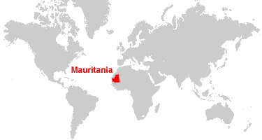
Mauritania is located in northern Africa. Mauritania is bordered by the Atlantic Ocean to the west, Algeria and Western Sahara to the north, Mali to the east and south, and Senegal to the south. Map by Geology.com.
Map of Mauritania by Geology.com

Mauritania is located in northern Africa. Mauritania is bordered by the Atlantic Ocean to the west, Algeria and Western Sahara to the north, Mali to the east and south, and Senegal to the south. Map by Geology.com.
Oregon Earthquakes Increase Local Landslide Risk
EOS

Researchers investigate the strength of Oregon’s coastal hillsides in the face of an earthquake. A USGS photograph of a section of Oregon Highway 101 after it was damaged by a landslide.
EOS

Researchers investigate the strength of Oregon’s coastal hillsides in the face of an earthquake. A USGS photograph of a section of Oregon Highway 101 after it was damaged by a landslide.
45,000-Year-Old Pig Painting in Indonesia May Be Oldest Known Animal Art
Smithsonian Magazine
Researchers believe that a pictograph found inside a limestone karst cave in Indonesia might be the earliest known example of figurative art.
Smithsonian Magazine
Researchers believe that a pictograph found inside a limestone karst cave in Indonesia might be the earliest known example of figurative art.
Types of Rock Art: Petroglyphs and Pictographs
Geology.com
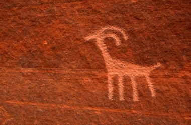
A petroglyph is an image that is carved into a rock. This "carving" can produce a visible indentation in the rock, or it can simply be the scratching away of a weathered surface to reveal unweathered material of a different color below. Image copyright iStockphoto / amygdala_imagery.
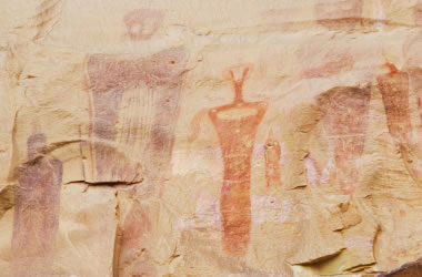
A pictograph is a drawing or painting that is created on a rock. It is not "carved" into the rock. Image copyright iStockphoto / Andrea Gingerich.
Geology.com

A petroglyph is an image that is carved into a rock. This "carving" can produce a visible indentation in the rock, or it can simply be the scratching away of a weathered surface to reveal unweathered material of a different color below. Image copyright iStockphoto / amygdala_imagery.

A pictograph is a drawing or painting that is created on a rock. It is not "carved" into the rock. Image copyright iStockphoto / Andrea Gingerich.
Anglo American, BHP and Others Cut Coal Mining Jobs
Mining.com
Today, much of the coal being exported is high grade metallurgical coal. Mine closures, tariffs and other pressures on the coal industry have reduced the need for workers.
Mining.com
Today, much of the coal being exported is high grade metallurgical coal. Mine closures, tariffs and other pressures on the coal industry have reduced the need for workers.
Huge Crater Under the North Sea Was Created by an Asteroid Impact
The Guardian
From the article: "Silverpit crater off Yorkshire coast was caused by cathedral-sized asteroid that set off 100-metre tsunami 43m years ago"
The Guardian
From the article: "Silverpit crater off Yorkshire coast was caused by cathedral-sized asteroid that set off 100-metre tsunami 43m years ago"
A Vast Source of Niobium Was Dragged to Earth's Surface When a Supercontinent Tore Apart
Live Science
Potentially the largest known source of niobium discovered in central Australia formed 830 million years ago, and we can thank the breakup of the ancient supercontinent Rodinia.
Live Science
Potentially the largest known source of niobium discovered in central Australia formed 830 million years ago, and we can thank the breakup of the ancient supercontinent Rodinia.
