Swift Quakes: Seismic Signals from Taylor Swift Concerts
EOS Science News
Quote from the article: "Each song typically had a seismic frequency that synced up with the song's beat rate as well as its harmonics, which have frequencies that are multiples of the beat rate."
EOS Science News
Quote from the article: "Each song typically had a seismic frequency that synced up with the song's beat rate as well as its harmonics, which have frequencies that are multiples of the beat rate."
U.S. Energy-Related Carbon Dioxide Emissions for 2023
Energy Information Administration
Quote from the article: "U.S. energy-related CO2 emissions decreased slightly in 2023 compared to 2022. Although emissions decreased across many economic sectors, more than 80% of U.S. energy-related CO2 emissions reductions in 2023 occurred in the electric power sector...."
Deciphering India's Luna Crater
NASA Earth Observatory
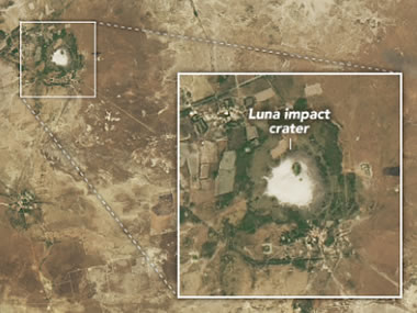
This round depression in western India, called the "Luna Crater" after a nearby town, measures about one mile (1.8 kilometers) across. People have long speculated that the crater might have formed as the result of a meteorite impact. Now that samples from the site have been analyzed, scientists are able to shed some light on the mystery of its formation. NASA Earth Observatory image by Michala Garrison, using Landsat data from the U.S. Geological Survey.
NASA Earth Observatory
This round depression in western India, called the "Luna Crater" after a nearby town, measures about one mile (1.8 kilometers) across. People have long speculated that the crater might have formed as the result of a meteorite impact. Now that samples from the site have been analyzed, scientists are able to shed some light on the mystery of its formation. NASA Earth Observatory image by Michala Garrison, using Landsat data from the U.S. Geological Survey.
The Vredefort Impact Crater
Geology.com
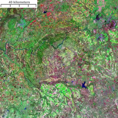
A Landsat image of the Vredefort Impact Crater. It was formed when an asteroid struck Earth about two billion years ago in an area that is now the country of South Africa. At the time of formation, the crater is believed to have been about 300 kilometers across. The Vaal River can be seen traversing the northern part of the structure. This image was composed by Angela King of Geology.com using Landsat Geocover data from NASA.
Geology.com
A Landsat image of the Vredefort Impact Crater. It was formed when an asteroid struck Earth about two billion years ago in an area that is now the country of South Africa. At the time of formation, the crater is believed to have been about 300 kilometers across. The Vaal River can be seen traversing the northern part of the structure. This image was composed by Angela King of Geology.com using Landsat Geocover data from NASA.
Dentist Discovers Human-Like Jawbone and Teeth in a Floor Tile at His Parents' Home
Smithsonian
Quote from the article: "Scientists are planning to study the specimen, embedded in travertine from western Turkey, in hopes of dating and identifying it."
Smithsonian
Quote from the article: "Scientists are planning to study the specimen, embedded in travertine from western Turkey, in hopes of dating and identifying it."
Misconceptions About the Anthropocene
Smithsonian
Should the so-called "Anthropocene epoch" be added to the Geologic Time Scale? Scientists are divided. This article outlines some of the common arguments against the Anthropocene, and provides counterpoints for consideration.
Smithsonian
Should the so-called "Anthropocene epoch" be added to the Geologic Time Scale? Scientists are divided. This article outlines some of the common arguments against the Anthropocene, and provides counterpoints for consideration.
NASA's Voyager 1 Resumes Sending Engineering Updates to Earth
NASA Jet Propulsion Laboratory

Voyager 1 was launched in 1977, and it has been sending data back to Earth ever since. In November 2023, its signals became unintelligible. Engineers have now identified the problem and are fixing the code so that the spacecraft can resume sending science data from its far-out location in interstellar space. Image by NASA / JPL-Caltech.
NASA Jet Propulsion Laboratory
Voyager 1 was launched in 1977, and it has been sending data back to Earth ever since. In November 2023, its signals became unintelligible. Engineers have now identified the problem and are fixing the code so that the spacecraft can resume sending science data from its far-out location in interstellar space. Image by NASA / JPL-Caltech.
Deluge in the United Arab Emirates
NASA Earth Observatory
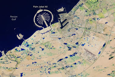
The United Arab Emirates was inundated when several slow-moving storms dropped over a year's worth of rain in less than 24 hours. The satellite image above shows the numerous flooded areas near the port city of Jebel Ali. NASA Earth Observatory images by Wanmei Liang, using Landsat data from the U.S. Geological Survey.
NASA Earth Observatory
The United Arab Emirates was inundated when several slow-moving storms dropped over a year's worth of rain in less than 24 hours. The satellite image above shows the numerous flooded areas near the port city of Jebel Ali. NASA Earth Observatory images by Wanmei Liang, using Landsat data from the U.S. Geological Survey.
The Artificial Islands of Dubai
Geology.com
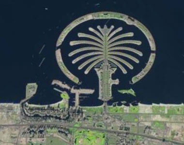
Did you know that there are hundreds of man-made islands in the Persian Gulf? Shown above are Bluewaters Island and the Palm Jumeirah. The satellite image was produced using 2018-2019 data from USGS LandsatLook.
Geology.com
Did you know that there are hundreds of man-made islands in the Persian Gulf? Shown above are Bluewaters Island and the Palm Jumeirah. The satellite image was produced using 2018-2019 data from USGS LandsatLook.
Is Geothermal Power Heating Up as an Energy Source?
Smithsonian
Quote from the article: "Long confined to regions with volcanic activity, the method of harnessing energy from the Earth promises to become much more versatile thanks to new technologies."
Smithsonian
Quote from the article: "Long confined to regions with volcanic activity, the method of harnessing energy from the Earth promises to become much more versatile thanks to new technologies."
Establishing Mount Shasta's Summit Elevation in the 20th Century
United States Geological Survey
Following a 1904 topographic survey of California, the U.S. Geological Survey revised the mountain's height from 14,444 feet (4,403 m) to 14,380 feet (4,383 m). This was a bit of a surprise! Today, even more sophisticated satellite elevation mapping has established Shasta's height at 14,163 feet (4,137 m) above sea level. What's going on?
Uncovering Earthquake Evidence in Azerbaijan's Greater Caucasus Mountains
EOS Science News
Quote from the article: "A new study unearths geological evidence that corroborates historical accounts of large earthquakes along the Kura fold-thrust belt."
EOS Science News
Quote from the article: "A new study unearths geological evidence that corroborates historical accounts of large earthquakes along the Kura fold-thrust belt."
The Seven Most Amazing Discoveries We've Made by Exploring Mercury
Smithsonian
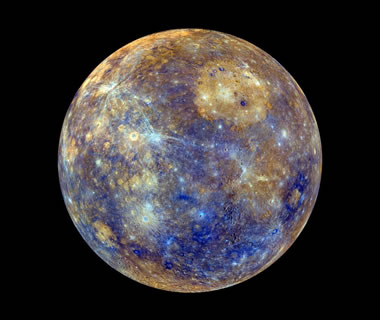
An image of Mercury with false-color enhancement to show the the age and mineral composition of surface materials. Image by NASA, JHU Applied Physics Lab, Carnegie Inst. Washington.
Smithsonian
An image of Mercury with false-color enhancement to show the the age and mineral composition of surface materials. Image by NASA, JHU Applied Physics Lab, Carnegie Inst. Washington.
Earth Day Resources for Science Teachers
National Science Teaching Association
Earth Day is on Monday, April 22, 2024. The National Science Teaching Association has a wealth of resources and free lesson plans available for teachers at all grade levels.
National Science Teaching Association
Earth Day is on Monday, April 22, 2024. The National Science Teaching Association has a wealth of resources and free lesson plans available for teachers at all grade levels.
National Park Service Seeks Help to Identify Lake Mead Vandals
FOX5 Las Vegas
On the evening of Sunday, April 7, two men were seen destroying rock formations in the Redstone Dunes Trail area of the Lake Mead National Recreation Area. The park is located about 30 miles east of Las Vegas, Nevada, and is home to geological formations that date back millions of years.
If you have any information about the suspects, please call the National Park Service Tip Line at 888-653-0009, or click here.
Biden Administration Restricts Oil and Gas Leasing in 13 Million Acres of Alaska's Petroleum Reserve
Associated Press
Associated Press
Father-Daughter Team Helps Discover Giant Prehistoric Sea Beast
Gift Article from the Washington Post
Gift Article from the Washington Post
NASA's Juno Gives Aerial Views of Mountain, Lava Lake on Io
NASA
This animation is an artist's concept of Loki Patera, a lava lake on Jupiter's moon Io, made using data from the JunoCam imager aboard NASA's Juno spacecraft. With multiple islands in its interior, Loki is a depression filled with magma and rimmed with molten lava. Credit: NASA/JPL-Caltech/SwRI/MSSS
Active Volcanoes of Our Solar System
Geology.com
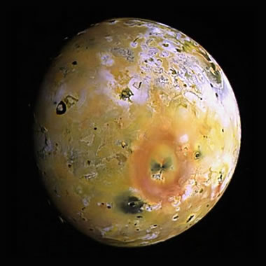
Io, a moon of Jupiter, is the most volcanically active body in our solar system. It has over 100 active volcanic centers, many of which have multiple active vents. Eruptions recurrently resurface large parts of the moon. NASA image.
Geology.com
Io, a moon of Jupiter, is the most volcanically active body in our solar system. It has over 100 active volcanic centers, many of which have multiple active vents. Eruptions recurrently resurface large parts of the moon. NASA image.
Brandberg Massif
NASA Earth Observatory
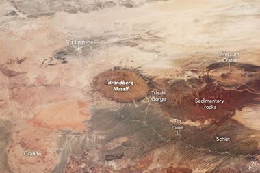
Brandberg Massif is the highest mountain in Namibia. Because there is a lack of deep soil in this area, different types of rocks are plainly visible on the surface, including granite, schist, and sedimentary rocks. Image by the International Space Station (ISS) Crew Earth Observations Facility and the Earth Science and Remote Sensing Unit, Johnson Space Center.
NASA Earth Observatory
Brandberg Massif is the highest mountain in Namibia. Because there is a lack of deep soil in this area, different types of rocks are plainly visible on the surface, including granite, schist, and sedimentary rocks. Image by the International Space Station (ISS) Crew Earth Observations Facility and the Earth Science and Remote Sensing Unit, Johnson Space Center.
Where Is Namibia?
Geology.com
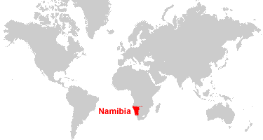
Namibia is located in southern Africa. Namibia is bordered by the Atlantic Ocean to the west, Angola to the north, Zambia and Botswana to the east, and South Africa to the southeast.
Geology.com
Namibia is located in southern Africa. Namibia is bordered by the Atlantic Ocean to the west, Angola to the north, Zambia and Botswana to the east, and South Africa to the southeast.
Massive Mount Ruang Eruption Sends Plumes Nearly 70,000 Feet High
Gift Article from the Washington Post
The explosions in Indonesia may have injected aerosols into the stratosphere. Ruang is a volcano on an island, north of the city of Manado, which is located on the northern peninsula of Sulawesi.
Gift Article from the Washington Post
The explosions in Indonesia may have injected aerosols into the stratosphere. Ruang is a volcano on an island, north of the city of Manado, which is located on the northern peninsula of Sulawesi.
Q: How Does a Desert Turn Green? A: Cloud Seeding?
CNBC
The United Arab Emirates and other "water-stressed" countries in the Middle East are experimenting with cloud seeding in an effort to develop "green landscapes".
CNBC
The United Arab Emirates and other "water-stressed" countries in the Middle East are experimenting with cloud seeding in an effort to develop "green landscapes".
The Town That Kept Its Nuclear Bunker a Secret for Three Decades
Smithsonian
Quote from the article: "The people of White Sulphur Springs, West Virginia, helped keep the Greenbrier resort's bunker - designed to hold the entirety of Congress - hidden from 1958 to 1992."
Smithsonian
Quote from the article: "The people of White Sulphur Springs, West Virginia, helped keep the Greenbrier resort's bunker - designed to hold the entirety of Congress - hidden from 1958 to 1992."
How King's College Added 438 Solar Panels to a 500-Year-Old Chapel
Smithsonian
Quote from the article: "The project sparked debate over how to decrease carbon emissions while preserving the historic structure's architectural beauty."
Smithsonian
Quote from the article: "The project sparked debate over how to decrease carbon emissions while preserving the historic structure's architectural beauty."
Meteorites are Vanishing Below the Antarctic Ice
CNN
More than half of the meteorites that have been collected so far have been found in Antarctica. The dark meteorites are easy to see on the snow-white surface. However, the meteorites' dark color also causes them to heat up in the sun, melting the surrounding ice. The meteorites can sink into the surface little by little, until they disappear from view.
Antarctica: The Best Place to Hunt Meteorites
Geology.com
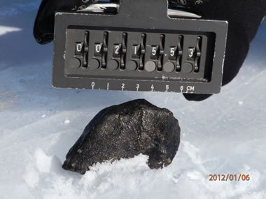
Meteorite Find: When meteorite hunters find a specimen in the field, it is photographed on-site with a measurement scale and an identification number visible in the background. NASA image.
Geology.com
Meteorite Find: When meteorite hunters find a specimen in the field, it is photographed on-site with a measurement scale and an identification number visible in the background. NASA image.
No Need to Spray for Cicadas
U.S. Environmental Protection Agency
Trillions of cicadas will be emerging across the United States in a few weeks - but don't panic! The bugs might look creepy, but they cannot bite or sting. They won't eat your flowers or garden produce, and they are for the most part harmless. You may want to protect young trees with netting, but don't use pesticides, as they are harmful to other organisms and will not be effective in keeping cicadas away.
The 2024 Periodical Cicada Emergence
University of Connecticut
If you're really interested in learning more about cicadas, The University of Connecticut has everything you ever wanted to know, and then some.
University of Connecticut
If you're really interested in learning more about cicadas, The University of Connecticut has everything you ever wanted to know, and then some.
Pennsylvania Geology (features Women in the Geosciences)
Pennsylvania Geological Survey
The link connects to a PDF downloadable document (13.93MB) and is best viewed on a desktop computer.
Pennsylvania Geological Survey
The link connects to a PDF downloadable document (13.93MB) and is best viewed on a desktop computer.
Mount Etna Puffs "Smoke Rings" Into the Sky
Smithsonian
See photos and a short video at SmithsonianMag.com - the "rings" are mostly condensed water vapor.
Smithsonian
See photos and a short video at SmithsonianMag.com - the "rings" are mostly condensed water vapor.
Mount Etna: Plate Tectonics, Geologic Hazards, Eruption History
Geology.com
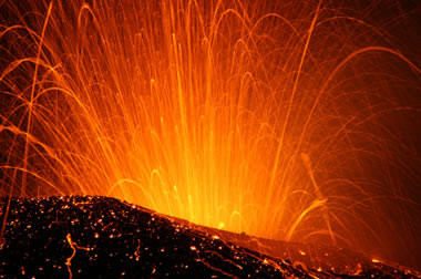
A night photo of Mount Etna producing an eruption of glowing ejecta in 2008. These spectacular eruptions can be seen from many parts of Sicily. Image copyright iStockphoto / Frizi.
Geology.com
A night photo of Mount Etna producing an eruption of glowing ejecta in 2008. These spectacular eruptions can be seen from many parts of Sicily. Image copyright iStockphoto / Frizi.
New Jersey Earthquake Fault Is Still Not Found, So USGS Deploys New Aftershock Sensors
NBC News
See the video about 1/2 way down the page.
NBC News
See the video about 1/2 way down the page.
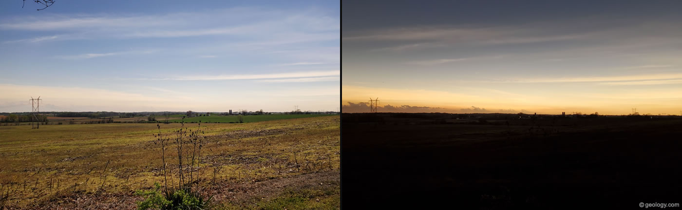
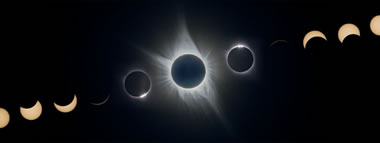
The Difference Between 99% Eclipse and Totality
Geology.com
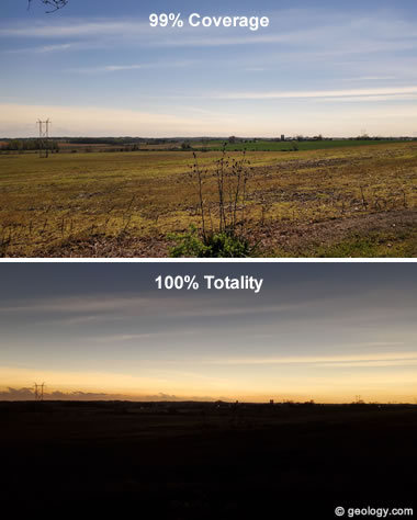
The photos above show the same location in Vincennes, Indiana during the 2024 solar eclipse. Believe it or not, these pictures were taken just one minute apart! The top photo was taken when the sun was about 99% covered, and the bottom photo was taken during 100% totality. As you can see, even with 99% coverage, the difference is like day and night! Click the image for a larger view. Photos by Patrick King / Geology.com.
Geology.com
The photos above show the same location in Vincennes, Indiana during the 2024 solar eclipse. Believe it or not, these pictures were taken just one minute apart! The top photo was taken when the sun was about 99% covered, and the bottom photo was taken during 100% totality. As you can see, even with 99% coverage, the difference is like day and night! Click the image for a larger view. Photos by Patrick King / Geology.com.
The Solar Eclipse, As Seen From Space
NASA Earth Observatory
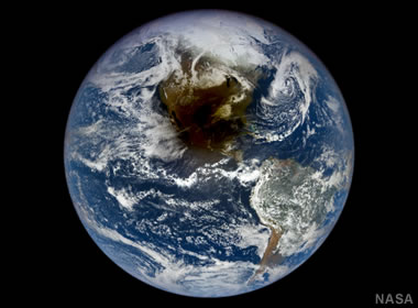
From a million miles away, the solar eclipse appeared as a dark shadow crossing over North America. NASA Earth Observatory images by Michala Garrison and Wanmei Liang, using data from DSCOVR EPIC and VIIRS data from NASA EOSDIS LANCE, GIBS/Worldview, and the Joint Polar Satellite System (JPSS).
NASA Earth Observatory
From a million miles away, the solar eclipse appeared as a dark shadow crossing over North America. NASA Earth Observatory images by Michala Garrison and Wanmei Liang, using data from DSCOVR EPIC and VIIRS data from NASA EOSDIS LANCE, GIBS/Worldview, and the Joint Polar Satellite System (JPSS).
Webinar: Unbottling the Environmental & Health Impacts of Nanoplastics
Columbia University Climate School
Columbia University Climate School
Just 57 Companies Linked to 80% of Greenhouse Gas Emissions
The Guardian
Quote from the article: "Although governments pledged in Paris to cut greenhouse gases... most mega-producers increased their output of fossil fuels and related emissions in the seven years after that climate agreement, compared with the seven years before."
The Guardian
Quote from the article: "Although governments pledged in Paris to cut greenhouse gases... most mega-producers increased their output of fossil fuels and related emissions in the seven years after that climate agreement, compared with the seven years before."
Studies Reveal Presence and Distribution of PFAs in New Mexico's Water Resources
United States Geological Survey
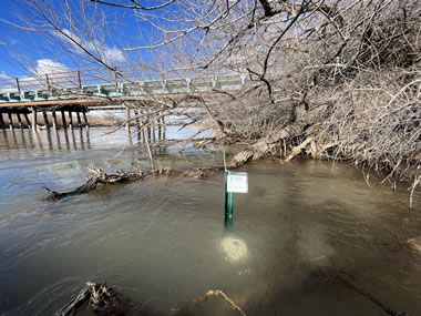
A USGS water quality sampler deployed on the Rio Grande to collect an integrated sample of PFAS in the water near Alameda, New Mexico. USGS photo.
United States Geological Survey
A USGS water quality sampler deployed on the Rio Grande to collect an integrated sample of PFAS in the water near Alameda, New Mexico. USGS photo.
Seabed 2030: Mapping the Ocean Floor
EOS Science News
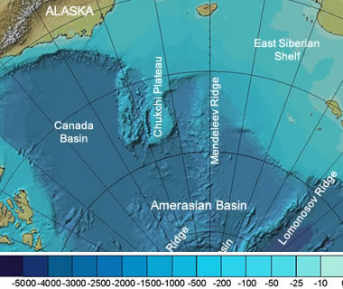
A project called Seabed 2030 aims to map the Earth's seafloor by the year 2030. They gather data from a variety of sources, and their findings are uploaded to the GEBCO grid - a free-access global terrain model. Shown above is a portion of a bathymetric map of the Arctic Ocean in color and shaded relief. Map by Intergovernmental Oceanographic Commission and others.
EOS Science News
A project called Seabed 2030 aims to map the Earth's seafloor by the year 2030. They gather data from a variety of sources, and their findings are uploaded to the GEBCO grid - a free-access global terrain model. Shown above is a portion of a bathymetric map of the Arctic Ocean in color and shaded relief. Map by Intergovernmental Oceanographic Commission and others.
No Canadian Volcanoes Meet Monitoring Standards
EOS Science News
Quote from the article: "A new analysis reveals serious monitoring gaps at even the highest-threat volcanoes."
EOS Science News
Quote from the article: "A new analysis reveals serious monitoring gaps at even the highest-threat volcanoes."
Watch the Solar Eclipse on Your Computer or Phone
Smithsonian
Here's how you can see the solar elcipse from the comfort of your own home - even if you live thousands of miles away. This article links to 5 different organizations that are offering a live stream of the solar eclipse, which can be viewed on your computer, tablet, or smartphone. Image by Don McCrady, displayed here under a Creative Commons License.
Gold Miners Work to Restore Peru's Amazon Rainforest
NPR
Illegal gold mining can transform a lush rainforest into a barren landscape with contaminated soil. In Peru, there is an initiative underway to help the miners restore part of the rainforest in Madre de Dios. The miners are also taught how to extract gold without the use of toxic mercury, which poisons the soil, water, fish, and the local people.
Where is Peru?
Geology.com
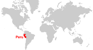
Peru is located in western South America. Peru is bordered by the Pacific Ocean to the west, Chile to the south, Bolivia and Brazil to the east, and Colombia and Ecuador to the north.
Geology.com
Peru is located in western South America. Peru is bordered by the Pacific Ocean to the west, Chile to the south, Bolivia and Brazil to the east, and Colombia and Ecuador to the north.
East Coast Earthquake - Did You Feel It?
United States Geological Survey
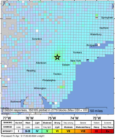
Over 15,000 people contributed their observation to the USGS "Did you feel it?" map. Earthquakes of 4.7 magnitude are very rare in the eastern United States. When they occur, they are usually felt over broad areas. If you felt this earthquake and want to contribute, go here.
United States Geological Survey
Over 15,000 people contributed their observation to the USGS "Did you feel it?" map. Earthquakes of 4.7 magnitude are very rare in the eastern United States. When they occur, they are usually felt over broad areas. If you felt this earthquake and want to contribute, go here.
Interactive Sea Level Rise Viewer for American Samoa
EOS
In the coming decades, rising sea levels and subsiding land will cause the inundation of coastal areas in American Samoa. Researchers and community leaders have created an interactive tool that can be used to visualize which areas are most at risk.
EOS
In the coming decades, rising sea levels and subsiding land will cause the inundation of coastal areas in American Samoa. Researchers and community leaders have created an interactive tool that can be used to visualize which areas are most at risk.
Illegal Oil and Gas Wastewater Dumps Disrupt Foundations of Fragile Desert Ecosystems
United States Geological Survey
United States Geological Survey
NASA Eclipse Explorer ** Highly Recommended! **
NASA
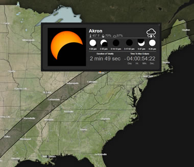
The NASA Eclipse Explorer is an interactive map that allows you to zoom in and click on U.S. cities to see eclipse-related information for that location. Find the duration of totality (or the maximum percent coverage), an illustrated timeline, live local weather conditions, and more.
NASA
The NASA Eclipse Explorer is an interactive map that allows you to zoom in and click on U.S. cities to see eclipse-related information for that location. Find the duration of totality (or the maximum percent coverage), an illustrated timeline, live local weather conditions, and more.
How the 2024 Total Solar Eclipse Is Different than the 2017 Eclipse
NASA
There are several ways in which the two eclipses differ. Image by Ernest Wright / NASA's Scientific Visualization Studio.
NASA
There are several ways in which the two eclipses differ. Image by Ernest Wright / NASA's Scientific Visualization Studio.
Strongest Earthquake in 25 Years Rocks Taiwan, Killing 9 People and Trapping 70 Workers in Quarries
Associated Press
Associated Press
How Hot Is Long Valley Caldera?
United States Geological Survey
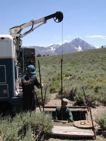
Quote from the article: "Measuring the temperature of lava erupting on the Earth's surface is possible with the right equipment. But how do you figure out the temperature of something miles below the surface? This week, we explore how scientists have tried to take the temperature of the Long Valley Caldera."
About the photo: "USGS scientists measuring temperature in a deep borehole in Long Valley Caldera with the Sierra Nevada mountains in the background. USGS photo by Chris Farrar."
United States Geological Survey
Quote from the article: "Measuring the temperature of lava erupting on the Earth's surface is possible with the right equipment. But how do you figure out the temperature of something miles below the surface? This week, we explore how scientists have tried to take the temperature of the Long Valley Caldera."
About the photo: "USGS scientists measuring temperature in a deep borehole in Long Valley Caldera with the Sierra Nevada mountains in the background. USGS photo by Chris Farrar."
Diagrammatic Cross Section of Long Valley Caldera
United States Geological Survey
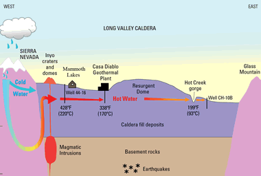
Cross section of Long Valley Caldera. The resurgent dome, Doe Ridge, Mammoth Mountain, and the Inyo Craters and Domes all reflect volcanic activity since 760,000 years ago, when a giant eruption formed the caldera. The thermal springs in Hot Creek are fed by Sierra Nevada snowmelt that seeps underground and migrates eastward in the vicinity of partially molten rock (magma) beneath the western part of the caldera. The water cools as it migrates eastward beneath the ground (red arrows). Image and caption by USGS.
For more information see: Hot Water in the Long Valley Caldera -- The Benefits and Hazards of this Large Natural Resource. (USGS Fact Sheet 2018-3009, March 2018.)
United States Geological Survey
Cross section of Long Valley Caldera. The resurgent dome, Doe Ridge, Mammoth Mountain, and the Inyo Craters and Domes all reflect volcanic activity since 760,000 years ago, when a giant eruption formed the caldera. The thermal springs in Hot Creek are fed by Sierra Nevada snowmelt that seeps underground and migrates eastward in the vicinity of partially molten rock (magma) beneath the western part of the caldera. The water cools as it migrates eastward beneath the ground (red arrows). Image and caption by USGS.
For more information see: Hot Water in the Long Valley Caldera -- The Benefits and Hazards of this Large Natural Resource. (USGS Fact Sheet 2018-3009, March 2018.)
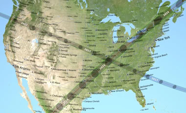
Eclipse Science Along the Path of Totality
EOS
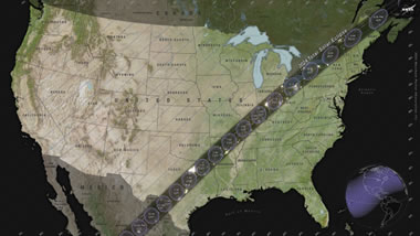
The upcoming solar eclipse on April 8 will provide unique opportunities for science-minded people across the continental United States. From Texas to Maine, researchers and citizen scientists alike will be collecting a wide range of data to help us better understand our planet, the sun, and the moon. Map by NASA's Scientific Visualization Studio.
EOS
The upcoming solar eclipse on April 8 will provide unique opportunities for science-minded people across the continental United States. From Texas to Maine, researchers and citizen scientists alike will be collecting a wide range of data to help us better understand our planet, the sun, and the moon. Map by NASA's Scientific Visualization Studio.
Partial: The Solar Eclipse for the Rest of Us
Sky & Telescope
If you live in North America but won't be in the path of totality on April 8, don't despair. There are still a number of things you can see to make the most of a partial eclipse!
Sky & Telescope
If you live in North America but won't be in the path of totality on April 8, don't despair. There are still a number of things you can see to make the most of a partial eclipse!
Medieval Castle Revealed Beneath Hotel in France
CBS News
At an excavation site in Vannes, France, archaeologists have uncovered the well-preserved remains of a medieval castle. The castle and its moat contained a variety of treasures and other items, such as coins, jewelry, and kitchenware.
CBS News
At an excavation site in Vannes, France, archaeologists have uncovered the well-preserved remains of a medieval castle. The castle and its moat contained a variety of treasures and other items, such as coins, jewelry, and kitchenware.
Birthstone for the Month of April: Diamond
Geology.com

Diamond is the traditional birthstone for the month of April. There are numerous choices for people who are looking for diamond birthstone jewelry. These days, shoppers can choose to buy lab-grown diamonds, Canadian diamonds, or even colored diamonds! Image copyright iStockphoto / Greg Stanfield.
Geology.com
Diamond is the traditional birthstone for the month of April. There are numerous choices for people who are looking for diamond birthstone jewelry. These days, shoppers can choose to buy lab-grown diamonds, Canadian diamonds, or even colored diamonds! Image copyright iStockphoto / Greg Stanfield.
The U.S. was the World's Largest Liquefied Natural Gas Exporter in 2023
U.S. Energy Information Association

In 2023, LNG exports from the United States averaged almost 12 billion cubic feet per day. Graph by EIA.
U.S. Energy Information Association
In 2023, LNG exports from the United States averaged almost 12 billion cubic feet per day. Graph by EIA.
What is LNG - Liquefied Natural Gas?
Geology.com

An LNG carrier ship docked at the Bontang LNG liquefaction terminal in East Kalimantan, Indonesia. The LNG is carried in the ship's four dome-shaped tanks. Image copyright iStockphoto / Mayumi Terao.
Geology.com
An LNG carrier ship docked at the Bontang LNG liquefaction terminal in East Kalimantan, Indonesia. The LNG is carried in the ship's four dome-shaped tanks. Image copyright iStockphoto / Mayumi Terao.
Las Vegas Is Going All In on Its Water Conservation Plan
Smithsonian
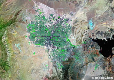
Las Vegas is known for excess and indulgence, so it might be surprising to hear that the city is leading the way in its water conservation efforts. As the Colorado River shrinks, but the population continues to grow, this juxtaposition has prompted local officials to come up with some ingenious solutions to ensure that there is still enough water to go around.
Shown above: A Landsat satellite image of Las Vegas, Nevada. Image created by Geology.com, using data from NASA's GeoCover. Click the image for a larger view.
Stone Age Humans Chose Their Rocks with Care
EOS
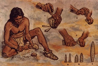
Prehistoric people became highly skilled at making tools and projectile points from rocks. National Park Service image.
EOS
Prehistoric people became highly skilled at making tools and projectile points from rocks. National Park Service image.
Flint: The Preferred Tool-Making Material
Geology.com
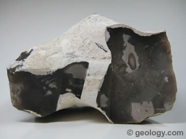
Flint is a variety of microcrystalline or cryptocrystalline quartz. It is a hard, tough material that has been used by humans to make tools for millions of years.
Geology.com
Flint is a variety of microcrystalline or cryptocrystalline quartz. It is a hard, tough material that has been used by humans to make tools for millions of years.
Why Scientists Want the Moon to Be Protected From Development
Smithsonian
Quote from the article: "Only a few lunar sites are ideal for certain cutting-edge research - and they're under threat from mining, satellites and bases."
Smithsonian
Quote from the article: "Only a few lunar sites are ideal for certain cutting-edge research - and they're under threat from mining, satellites and bases."
Who Owns the Moon?
Geology.com
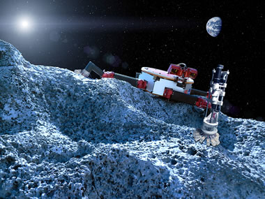
Does any country, company, or individual have the right to own celestial bodies or their minerals? Shown above is an artist depiction of what mining in space might look like. NASA image.
Geology.com
Does any country, company, or individual have the right to own celestial bodies or their minerals? Shown above is an artist depiction of what mining in space might look like. NASA image.
Quiet Night Over Eastern Canada
NASA Earth Observatory
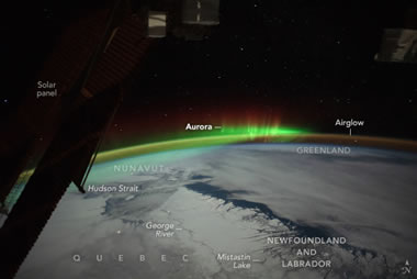
In this photo, taken by an astronaut aboard the International Space Station, the aurora borealis looks like it is "floating" over the Earth. Image provided by the ISS Crew Earth Observations Facility and the Earth Science and Remote Sensing Unit, Johnson Space Center.
NASA Earth Observatory
In this photo, taken by an astronaut aboard the International Space Station, the aurora borealis looks like it is "floating" over the Earth. Image provided by the ISS Crew Earth Observations Facility and the Earth Science and Remote Sensing Unit, Johnson Space Center.
Aurora Australis from Space
Geology.com
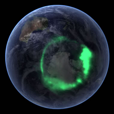
The Aurora Australis, also known as the "Southern Lights," is a natural light display that occurs in Earth's atmosphere above Antarctica and the Southern Ocean. The image was compiled by superimposing data of the Aurora Australis collected by NASA's IMAGE satellite atop of an image of Earth from a south polar perspective from the Blue Marble project. The result simulates what the Aurora Australis would look like from a satellite orbiting above. Image by NASA.
Geology.com
The Aurora Australis, also known as the "Southern Lights," is a natural light display that occurs in Earth's atmosphere above Antarctica and the Southern Ocean. The image was compiled by superimposing data of the Aurora Australis collected by NASA's IMAGE satellite atop of an image of Earth from a south polar perspective from the Blue Marble project. The result simulates what the Aurora Australis would look like from a satellite orbiting above. Image by NASA.