Geological Terms Beginning With "P"
For terms beginning with other letters, please click below
|
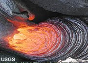
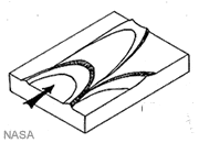
Pahoehoe
A Hawaiian term for a lava flow that has a surface flow structure that looks like coiled rope or cord. Lavas with a relatively low viscosity can form a "ropy" surface. The term is also used for the rock materials after the flow has cooled.
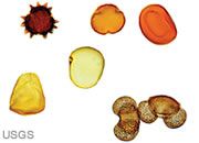
Paleoclimate
The climate of a given area at a specific time in the past. Paleoclimates of an area can be determined by examining the characteristics of sedimentary rocks such as their fossils, minerals, sedimentary structures. Paleoclimates can also be determined from ice cores. The photo shows pollen grains that can be used to determine climatic conditions in their source area.
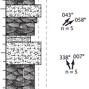
Paleocurrent Map
A map that shows the directions of currents at the time of sediment deposition. These directions can be determined through the study of cross bedding, ripple marks, tool marks and other sedimentary structures. The image is a field-note representation of the rock types present at a given location and the paleocurrent directions inferred from sedimentary structures.
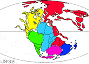
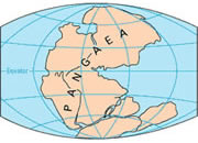
Paleogeographic Map
A map that shows the distribution of sedimentary environments at a specific time in the past. These maps are made by studying the rock record to correlate rock units that were deposited at the same time, then relating rock characteristics to specific sedimentary environments. They can also show the relative positions of landmasses on the face of the Earth at specific times in the past. The map at left shows the relative position of Earth's landmasses and seas approximately 210 million years ago.
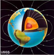
Paleomagnetism
The study of Earth's magnetic field over time. When rocks that contain magnetic minerals are deposited, the character (vertical and horizontal orientation along with polarity) of Earth's magnetic field is locked within the rocks. This information can be used to study changes in Earth's magnetic field as well as the movement of plates over time. The image shows the current configuration of Earth's magnetic field.
Paleontology
The study of the changes in Earth's life over space and time through the study of rock units and the fossils contained within them.
Pangaea
A large continental landmass that existed from about 300 million years ago through about 200 million years ago. It included most of the continental lithosphere present at that time. It has since broken up and the fragments have drifted to become the configuration of Earth's present day continents.
Panthalassa
The ancient ocean that surrounded the Pangaea landmass.
Parabolic Dunes
Sand dunes with a U-shaped outline. They have a convex nose and two trailing horns that point upwind. Parabolic dunes form in areas with a single dominant wind direction that blows up the gentle slope on the trailing side of the dune and drops the sand on the steep side of the dune. The dunes move slowly down wind and are common in coastal areas.
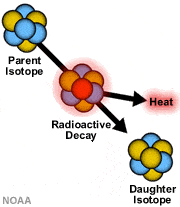
Parent Isotope
A radioactive isotope that spontaneously decays into a new substance along with a release of heat. The product of this decay is known as a "daughter" isotope.
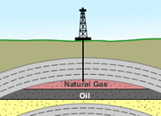
Pay or Pay Zone
The portion of an oil or gas reservoir that contains hydrocarbon and is capable of yielding profitable amounts of oil or gas. The term is usually used in reference to the rocks at a particular depth or a laterally traceable rock unit. In the image the portion of the sandstone rock unit that contains natural gas and oil is a "pay zone."

Peak Flow
The maximum instantaneous discharge of a stream at a specific location. Corresponds to the highest stage of a flood. The hydrograph at left shows a peak flow of a little over 200 cubic feet per second.
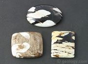
Peanut Wood
A variety of petrified wood from Australia. Some pieces have white markings that remind people of peanuts. It is a fossil driftwood that has been bored by marine clams.
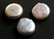
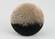
Pearls
Pearls are a very popular gem material. They are produced by shellfish, and people have used them for personal adornment for thousands of years. These are cultured freshwater pearls produced in Tennessee.
Peat
An accumulation of unconsolidated plant debris that if buried and preserved could become coal. Special conditions are required to accumulate and preserve plant materials. These conditions are most often found in a marsh or swamp where water cover prevents oxidation and attack by most organisms.
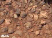
Pebble
A term used for a sedimentary particle that is between 4 and 64 millimeters in size. Pebbles are larger than granules but smaller than cobbles. Pebbles have typically been rounded by abrasion during sedimentary transport. The photo shows a deposit of pebble-sized sedimentary particles found on the surface of Mars discovered by Mars Rover Curiosity in 2012. The largest particle in the photo is about one centimeter across.

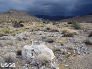
Pediment
A broad, gently sloping erosional surface of low local relief adjacent to an eroding cliff or mountain range. The area is likely covered with sediments.
Pegmatite
A very coarse-grained igneous rock, normally of granitic composition. Typically forms during the final states of magma chamber crystallization when the high water content solutions allow rapid crystal growth.
Pelagic Sediment
An ocean sediment that accumulates far enough from land that detrital materials are a minor component. These sediments are largely composed of the tiny shell debris of radiolarians and foraminifera.
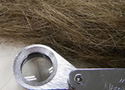
Pele's Hair
Pele's Hair is the name used for hair-like strands of volcanic glass that sometimes form in areas where lava fountaining, lava cascades and vigorous lava activity occur. They are less than 1/2 millimeter in width, but can be up to two meters in length. They resemble golden-brown human hair in their size, shape and color. They are a mineraloid formed from basaltic lava. Creative Commons photograph by Cm3826.
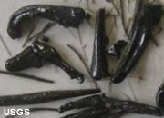
Pele's Tears
Pele's Tears are teardrop-shaped pieces of volcanic glass that can form in areas where lava fountaining, lava cascades and vigorous lava activity occur. They are particles of basaltic lava that erupted into the air and solidifed during their fall back to Earth. They are often found in association with Pele's Hair.
Perched Water Table
A water table that is isolated from and higher than the regional water table. This can occur when a hilltop is underlain by an impermeable rock unit. Infiltrating waters stack up on the impermeable unit, creating an isolated water table that is higher than the water table of the surrounding land.
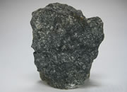
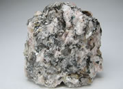
Peridotite
A dark-colored, coarse-grained igneous rock that is made up mainly of olivine and pyroxene, with very little quartz or feldspar.
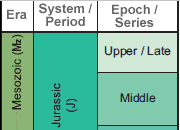
Period
A unit of geologic time that is longer than an epoch but shorter than an era. From oldest to youngest, Cambrian, Ordovician, Silurian, Devonian, Mississippian, Pennsylvanian, Permian, Triassic, Jurassic, Cretaceous, Tertiary and Quaternary are periods of the geologic time scale,
Permeability
A measure of how well a material can transmit water. Materials such as gravel, that transmit water quickly, have high values of permeability. Materials such as shale, that transmit water poorly, have low values. Permeability is primarily determined by the size of the pore spaces and their degree of interconnection. Permeability measures are expressed in units of velocity, such as centimeters per second, and assume a gradient of one vertical foot of drop per linear foot.
Petrified Palm
Louisiana has been the "bayou state" for over 100 million years. During that history, many palms have been fossilized. Today they are called "petrified palm wood" (but they really are not wood) and polished into beautiful gems.
Petrified Wood
A fossil that is formed when woody material is buried, then dissolved materials in groundwater precipitate to replace and infill the wood structure with silica, opal, or other mineral material.
Petrochemicals
Organic and inorganic compounds and mixtures that are derived from petroleum. These include: organic chemicals, cyclic intermediates, plastics, resins, synthetic fibers, elastomers, organic dyes, organic pigments, detergents, surface active agents, carbon black, and ammonia.
 All scientific disciplines have an essential vocabulary that students and professionals must understand to learn and communicate effectively. A geology dictionary that is used regularly is one of the most important tools for developing professional competence. A good dictionary should be on the desk of every geologist and within easy reach. This dictionary is compact and inexpensive at only $19.99. More information. |
Petroleum
A group of liquid hydrocarbons that includes: crude oil, lease condensate, unfinished oils, refined products obtained from the processing of crude oil, and natural gas liquids.
pH
A relative measure of the acidity or alkalinity of a water based upon a scale that ranges between 0 and 14 with 7 being neutral. Values of pH below 7 indicate acid solutions and values of pH above 7 indicate basic solutions.
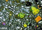
Photomicrograph
A thin slice of rock prepared for microscopic examination. It is prepared by gluing a small cube of rock to a microscope slide and cutting/grinding it to such a thinness that light will pass through the non-opaque minerals. Then, when observed in reflected and transmitted light using various filters, the mineral and other components of the rock can be identified by a skilled observer. Quantifying the relative abundances of the minerals will allow the rock to be more specifically named and its history understood. The image here is a photomicrograph of basalt in polarized light with visible plagioclase (shades of gray) and olivine (orange-yellow-green) crystals visible.
Phreatomagmatic
An explosive volcanic eruption initiated by the interaction of magma and water (usually either meteoric or groundwater).
Physical Weathering
A general term applied to a variety of weathering processes that result in the particle size reduction of rock materials with no change in composition. Frost action, salt crystal growth and pressure relief fracturing, abrasion, are examples. Also known as mechanical weathering. The photo shows granite pebbles and boulders on the flood plain of a wash where flash floods pick up, carry, and abrade the sediment particles. In the winter the forces of freezing and thawing slowly damage the rocks.
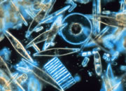
Phytoplankton
Microscopic organisms that grow in surface waters and serve as the base of the ocean's food chain. Types of phytoplankton include diatoms (pictured), coccolithophores, cyanobacteria, dinoflagellates, green algae, and others.
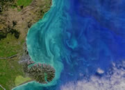
Phytoplankton Bloom
An explosive growth in the number of phytoplankton on the surface waters of an ocean, lake, or other body of water. Phytoplankton are normally present at the water's surface, but when the temperature, sunlight, and water composition are just right, the phytoplankton can multiply exponentially, creating a noticeable blue-green "bloom" on the water.
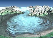
Piedmont Glacier
An ice sheet found on the relatively flat land at the base of a mountain range where one or more valley glaciers emerge from the mountain range and spread out over the relatively flat area. The NASA image at left is an enhanced Landsat view of a portion of the Malaspina Glacier of Alaska.

Pigment Minerals
Pigment minerals are mineral materials that are mined or collected because they can be used as a pigment. People have been collecting minerals and using them as pigments for about 40,000 years. Hematite is used to produce a wide range of red to reddish-brown pigments. Limonite (a mineraloid) has been used to produce yellow to brown pigments as shown in the photo. Glauconite is used to create green, lazurite for blue, psilomelane for black, cinnabar for red, orpiment for orange, malachite for green, and, barite for white. These are just a few examples of minerals used as pigments. The pigment minerals can be mixed with oil, water and other liquids for use as a paint. They can also be used to give color to plaster, stucco, cosmetics, chalk and similar material.
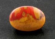
Pinfire Opal
An opal that exhibits pin points of fire instead of a broad flash is known as "pinfire opal."
Placer Deposit
A mass of stream sediment that contains an economically significant concentration of mineral particles. This concentration of mineral particles usually occurs when the particles have a high specific gravity and/or are resistant to weathering. Gold, cassiterite, magnetite, diamonds, ruby, sapphire, garnet, and many other gemstones can be found in placer deposits.
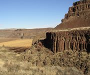
Plateau Basalt
A sequence of laterally extensive basalt flows, formed over a brief period of geologic time, that now, when eroded, can produce a landscape of terraces and plateaus. They often form plateaus such as the one seen in the distance in the photo, a view of the Columbia River basalts of Washington.
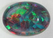
Play-of-Color
A display of spectral colors produced with light passing through a gemstone encounters a regular pattern of tiny spheres, layers or other structures that diffract the light into its component colors. Opal is especially well-known for its "play-of-color" in which an observer can move the stone under a source of light and see the colorful flashes as the angle of light in the stone is changed. The colors will also change if the observer's eye moves or if the source of the light is moved. It is this play-of-color that defines precious opal. Without that display of color the opal is "common."
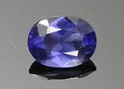
Pleochroism
A change of a gem's body color when it is viewed from different crystallographic directions. As an example, if you have a crystal of transparent iolite, hold it between your eye and a source of light and rotate the stone through 360 degrees, the color of the stone will change with every 90 degrees of rotation. The color of the specimen depends upon the angle of observation. When pleochroic stones are faceted or cut en cabochon, the cutter must be knowledgeable of the pleochroic characteristics of the stone so it can be oriented in a way that shows optimal color to the observer.
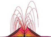
Plinian Eruption
An explosive eruption where large volumes of rock, ash and gas are blasted at high velocity from a vent. These eruptions produce huge clouds that can rise tens of kilometers into the atmosphere.
Point-Source Pollution
Water contamination that can be traced to a single point. A toxic material spill and a sewage discharge pipe are examples of point sources.
Polarity Epoch
An interval of time between reversals of Earth's magnetic field.
Polarity Event
A specific event in the history of Earth's magnetic field. Usually used in reference to a specific polarity reversal.
Polarity Reversal
A change in the polarity of Earth's magnetic field in which the north magnetic pole becomes the south magnetic pole and vice versa. Also known as geomagnetic reversal or magnetic reversal. Earth's magnetic field has reversed many times in the past and the time intervals between these changes are known as polarity epochs.
Porosity
The volume of pore space in a rock, sediment or soil. Usually expressed as a percentage. This pore space can include openings between grains, fracture openings and caverns.
Potable Water
Water that is of adequate quality for drinking.
Pothole
A cylindrical or hemispherical hold in the bedrock of a stream that is formed from the continual swirling motion of sand and gravel by swirling currents.
PPM
An abbreviation for parts per million.
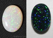
Precious Opal
An opal that produces flashes of iridescent color when moved under incident light. The color display is known as "play-of-color." Some examples of precious opal: black opal, boulder opal, crystal opal, pinfire opal, and white opal.
Opals that do not show play-of-color are called common opal.
Precious Stones
"Precious stones" is a name that is usually used in reference to four types of gems: diamonds, rubies, sapphires, and emeralds. Some people have included opal, jade, or pearls in the "precious stones" class, but these have not received persistent and widespread use. Gems that are outside of the "precious stones" class are referred to as "semiprecious stones." These classifications of gemstones became popular in the 1800s, and most members of the gems and jewelry industry have used them. Today many people believe that the use of the term "semiprecious" is derogatory because any material worthy for use as a gemstone should be considered as "precious."
Precipitation
Movement of water from the atmosphere to the land or to a surface water body. Rain, hail, snow, dew, and sleet are all examples of precipitation.
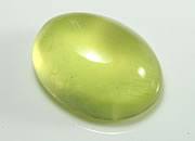
Prehnite
Prehnite is a calcium aluminum silicate mineral. Specimens with nice color and clarity are often cut as gems. This gemmy yellow prehnite cabochon was cut from material mined in Australia.
Primary Recovery
Any crude oil or natural gas that is recovered from a well as a result of the natural pressure within the reservoir.
Primary Seismic Waves
The fastest set of earthquake vibrations - also known as P-waves. They move through the Earth in compression and expansion motions (much like sound waves move through air). Called primary because they are the first recorded at a seismograph. Primary waves are able to travel through both solids and liquids.
Prospecting
The activities associated with the search for an area of probable mineralization. It can include: topographical, geological, geochemical and geophysical studies. Prospecting is usually done prior to the acquisition of mineral rights.
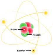
Proton
A subatomic particle, contained in the nucleus of an atom. It has a positive electrical charge and a mass similar to that of a neutron.
Proto-Sun
An intermediate stage in the development of a star in which a large cloud of dust and gases gradually condenses through gravitational actions.
Proven Reserves
Mineral deposits that have been explored thoroughly enough to be quantified but which are still in the ground.
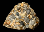
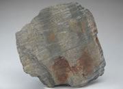
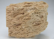
Puddingstone
Puddingstone is a nonscientific name for a conglomerate composed of subangular to rounded clasts over 2 millimeters in diameter, in a matrix of sharply contrasting color. A piece of the Hertfordshire puddingstone from Hertfordshire County, England is shown in the photo. It is composed of rounded flint pebbles in a gray silicate matrix. Image by John Cancalosi / Alamy Photos.
Pumice
A vesicular volcanic glass of granitic composition. It has so many vesicles that it has a very low specific gravity - sometimes low enough to float on water.
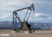
Pumpjack
A pump used on an oil well when there is not enough bottom hole pressure to push the oil to Earth's surface. The pumpjack is a mechanical device that converts the rotary action of a motor to a lifting action needed for a reciprocating piston pump. They can be powered by electricity but where that is not available, gasoline, diesel, propane and natural gas are used.
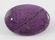
Purpurite
Purpurite is a manganese phosphate mineral with a bold purple color that is often cut into cabochons. It has a low hardness (4 to 5) so is best used in jewelry that is not expected to receive rough wear.
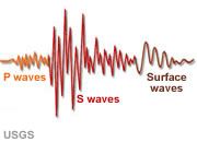
P-wave
Primary seismic waves. The fastest set of earthquake vibrations. They move through the Earth in compression and expansion motions (much like sound waves move through air). Called primary because they are the first recorded at a seismograph. Primary waves are able to travel through both solids and liquids.
Pyroclastic
The word "pyroclastic" is an adjective used for volcanic clasts that are blown from a volcanic vent. Rocks and rock materials of a volcanic origin are also called "pyroclastics."
Pyroclastic Flow
A hot, high-velocity mixture of ash, gas and fragmented rock that flows like a liquid down slopes and over terrain.
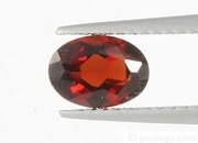
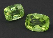
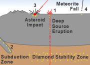
Pyrope
Pyrope is a magnesium aluminum garnet that is usually red in color. It is often formed in the mantle and transported to the surface in deep-source volcanic eruptions that form diamond deposits.
Pyroxene
Pyroxenes are members of a group of rock-forming minerals found in igneous and metamorphic rocks throughout the world. They are single-chain silicate minerals with a generalized chemical composition of XYSi2O6, where X can be Ca, Na, Fe++, Mg, Zn, Mn, or Li; and Y can be Mg, Fe+++, Fe++, Cr, Al, Co, Mn, Sc, Ti, or Vn. They are important constituents of dark-colored igneous rocks such as gabbro, basalt, and peridotite. Some of the best-known pyroxene minerals include augite, diopside, jadeite and spodumene.
|
| More General Geology |
 |
Diamonds from Coal? |
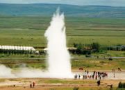 |
What is a Geyser? |
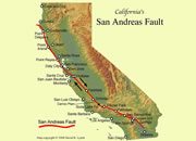 |
What is the San Andreas Fault? |
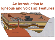 |
Igneous and Volcanic Features |
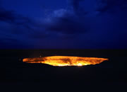 |
The Doorway to Hell |
 |
Topo Maps |
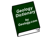 |
Geology Dictionary |
 |
Gifts That Rock |

Find Other Topics on Geology.com:

|

| ||

|

| ||

|

| ||

|

|