Home » World Maps » World Map
World Map - Political - Click a Country


ADVERTISEMENT
Buy a United States Wall Map

This is a large 38" by 48" colorful wall map showing the United States of America and state flags.
More Information.
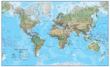
Political Map of the World
Shown above
The map above is a political map of the world centered on Europe and Africa. It shows the location of most of the world's countries and includes their names where space allows.
Representing a round earth on a flat map requires some distortion of the geographic features no matter how the map is done. We have used a Mercator projection for this map because it is the projection most commonly used in schools. On this map, geographic boundaries that trend north-south appear as vertical lines, geographic boundaries that trend east-west appear as horizontal lines. This type of projection causes a minimum of country-shape distortion near the equator, a small amount of distortion at mid-latitudes, but extreme distortion near the poles. For that reason, the map does not extend to the north and south poles.
Buy a World Wall Map

This is a large 38" by 51" wall map with vibrant colors and good detail.
Click here for more wall maps!
Use Google Earth Free
 Google Earth is a free download that lets you view satellite images of Earth on your computer or phone.
CIA Political Map of the World

Political maps of the world prepared by the United States Central Intelligence Agency.
World Country Outline Maps
 Zoomable .pdf maps of the world showing the outlines of major countries. Get a world outline map.
Satellite Image Maps of U.S. States
 View each of the 50 U.S. states in a large satellite image from the LandSat Satellite. View States.
CIA Time Zone Map of the World
 The United States Central Intelligence Agency standard time zone map of the world in .pdf format. Easy-to-read.
World Map of Cities at Night
 NASA's World Map of Earth's illumination at Night. gives you a simulated view of Earth from space at night.
Maps of the World's Oceans
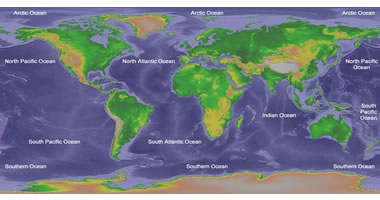
World maps showing the bathymetry, major physical features, and boundaries of Earth's oceans.
Types of Maps
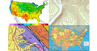
Did you know that there are thousands of types of maps? Learn about the maps shown here and more.
Countries of the World

We have maps and information for almost every country in the world, from Afghanistan to Zimbabwe.
World Physical Map

Buy a Physical World Wall Map
This is a large 33" by 54" wall map with the world's physical features shown.
More Information.
Physical Map of the World
Shown above
The map shown here is a terrain relief image of the world with the boundaries of major countries shown as white lines. It includes the names of the world's oceans and the names of major bays, gulfs, and seas. Lowest elevations are shown as a dark green color with a gradient from green to dark brown to gray as elevation increases. This allows the major mountain ranges and lowlands to be clearly visible.
This map is also a Mercator projection centered on Europe and Africa. A scale of miles is not shown on these maps because the scale changes with distance north and south of the equator. Scale is highly exaggerated as distance from the equator increases.
Note: The map above shows names and political boundaries as depicted on maps published by the CIA World Factbook, which we use as our primary reference for geographic information as recognized by the United States.

Countries of the World:
The United States Department of State recognizes 195 "Independent States in the World". We have listed these countries below, and those that we have a map for are clickable.
Afghanistan
Albania
Algeria
Andorra
Angola
Antigua and Barbuda
Argentina
Armenia
Australia
Austria
Azerbaijan
Bahamas, The
Bahrain
Bangladesh
Barbados
Belarus
Belgium
Belize
Benin
Bhutan
Bolivia
Bosnia and Herzegovina
Botswana
Brazil
Brunei
Bulgaria
Burkina Faso
Burma (Myanmar)
Burundi
Cabo Verde
Cambodia
Cameroon
Canada
Central African Republic
Chad
Chile
China
Colombia
Comoros Islands
Congo, Dem. Rep. of the
Congo, Republic of the
Costa Rica
Cote d'Ivoire
Croatia
Cuba
Cyprus
Czech Republic
Denmark
Djibouti
Dominica
Dominican Republic
Ecuador
Egypt
El Salvador
Equatorial Guinea
Eritrea
Estonia
eSwatini (formerly Swaziland)
Ethiopia
Fiji
Finland
France
Gabon
Gambia, The
Georgia
Germany
Ghana
Greece
Grenada
Guatemala
Guinea
Guinea-Bissau
Guyana
Haiti
Holy See
Honduras
Hungary
Iceland
India
Indonesia
Iran
Iraq
Ireland
Israel
Italy
Jamaica
Japan
Jordan
Kazakhstan
Kenya
Kiribati
Korea, North
Korea, South
Kosovo
Kuwait
Kyrgyzstan
Laos
Latvia
Lebanon
Lesotho
Liberia
Libya
Liechtenstein
Lithuania
Luxembourg
Madagascar
Malawi
Malaysia
Maldives
Mali
Malta
Marshall Islands
Mauritania
Mauritius
Mexico
Micronesia, Federated States of
Moldova
Monaco
Mongolia
Montenegro
Morocco
Mozambique
Namibia
Nauru
Nepal
Netherlands
New Zealand
Nicaragua
Niger
Nigeria
North Macedonia, Republic of
Norway
Oman
Pakistan
Palau
Panama
Papua New Guinea
Paraguay
Peru
Philippines
Poland
Portugal
Qatar
Romania
Russia
Rwanda
Saint Kitts and Nevis
Saint Lucia
Saint Vincent & the Grenadines
Samoa
San Marino
Sao Tome and Principe
Saudi Arabia
Senegal
Serbia
Seychelles
Sierra Leone
Singapore
Slovakia
Slovenia
Solomon Islands
Somalia
South Africa
South Sudan
Spain
Sri Lanka
Sudan
Suriname
Sweden
Switzerland
Syria
Tajikistan
Tanzania
Thailand
Timor-Leste
Togo
Tonga
Trinidad and Tobago
Tunisia
Turkey
Turkmenistan
Tuvalu
Uganda
Ukraine
United Arab Emirates
United Kingdom
United States of America
Uruguay
Uzbekistan
Vanuatu
Venezuela
Vietnam
Yemen
Zambia
Zimbabwe

ADVERTISEMENT